Mine Index Number: 1037
| Company Name:
|
S Coal Company
|
| Mine Name:
|
Elkville Mine
|
| Start Date:
|
2004
|
End Date:
|
2009
|
| Type of Mine:
|
Surface
|
| Total acres shown:
|
91
|
| Acres after map date:
|
|
General Area of mining acres shown:
|
|
|
|
Shaft, Slope, Drift or Tipple Location(s)
| Type
|
County
|
Township-Range
|
Section
|
Part Section
|
| Pit
|
Jackson
|
7S 1W
|
19
|
E ½ NE
|
Geology
Geological Problems Reported
Production
| Company
|
Mine Name
|
Date
|
Production (tons)
|
Production Notes
Coal Report production (if available)
Sources of Data
| Coal Section files, digital map
|
2009
|
Not known
|
1:24000
|
Not final
|
Annotated Bibliography (Data source - brief description of information)
| Coal Reports - Production, ownership, years of operation, seams, depth, thickness.
|
| Directory of Illinois Coal Mines (Jackson County) - Mine names, mine index, ownership, years of operation.
|
| Coal Section files, digital map - Mine outline, mining method.
|
Mine Notes
Mine Images
Photographs
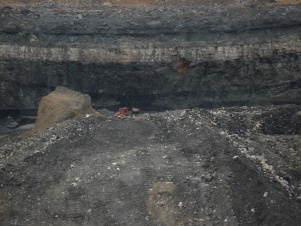
Caption: Herrin Coal at the S Coal surface mine near Elkville, IL. Herrin coal at the base of the highwall ‘splits’ or separates apart both to the right and left from a central intact portion, with Energy shale intercalated between the upper and lower coal benches. Coal splits that are found close to penecontemporaneous river channels, such as this example near the Walshville paleochannel, are likely formed by erosion at the channel margins that creates peat flaps that float, followed by sediment deposition infilling below the flaps, and on top.
Date: November 19, 2009


