Mine Index Number: 7811
| Company Name:
|
Central Mining Company
|
| Mine Name:
|
Burning Star No. 1
|
| Start Date:
|
1993
|
End Date:
|
1994
|
| Type of Mine:
|
|
| Total acres shown:
|
None
|
| Acres after map date:
|
|
General Area of mining acres shown:
|
|
|
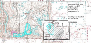
Not Shown On Map. The 1993 production was only listed in the "mode of shipment" table. According to Dean Spindler, DNR, this was a carbon recovery company. As such, the 1993 production may have been from a slurry pond or a stockpile of coal fines. The 1994 production was listed in the "physical characteristics" table, but may have come from the same source or they may have mined from reserves left at the site. The mine name (Burning Star) most likely refers to mine index 0684, Truax Traer Coal Co.'s Burning Star No. 1 Mine.
|
Shaft, Slope, Drift or Tipple Location(s)
| Type
|
County
|
Township-Range
|
Section
|
Part Section
|
| Tipple
|
Jackson
|
7S 2W
|
36
|
E1/2 SE
|
Geology
Geological Problems Reported
Production
| Company
|
Mine Name
|
Date
|
Production (tons)
|
Production Notes
Coal Report production (if available)
Sources of Data
| IDNR permit #125
|
1998
|
1:3600
|
1:3600
|
Secondary source
|
Annotated Bibliography (Data source - brief description of information)
| IDNR permit #125, as shown on map of Razorback Mine (mine index 1020), Coal Section files 6-352 - Mine location.
|
| Coal Reports - Production, ownership, years of operation, mine type, depth, thickness.
|
Mine Notes
Mine Images
IDNR GIS files:
Coal Co.: Central Mining Company
Mine Name: Burning Star No. 1
Photographs

