Underground Mine Buffer Region
Locations of some mine features may be offset by 500 feet or more due to errors in the original source maps, the compilation process, digitizing, or a combination of these factors. The "Underground Mine Buffer Region" (the yellow areas on the map) represent these possible errors and other factors. These errors and the method of creating it are briefly discussed below.
- Final/Not Final Maps
The date on the map is used to determine if a map is final (made after coal mining completed) or not final (maps may be dated months or years before mining stops). If a map is not final the outline of the mine may not accurately reflect the final size of the map. This discrepancy could be a few acres to hundreds of acres. - Digitizing
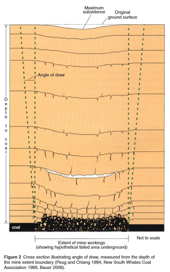
Georegistration or the act of matching a map to real world locations. Some maps have several good points that can be matched to real world locations, while other maps may only have one or a few points, resulting in a poor match to the real world. This can result in a mine map being a few feet off to several hundred feet off. - Angle of Draw (Text and Figure from Circular 575, The Proximity of Underground Mines to Urban and Developed Lands in Illinois Pages 3 & 4)
Zone 1 is defined as the area directly over the mapped extent of the mines (red areas on the map) and the adjacent land extending some distance beyond the mine boundaries (yellow areas on the map). Land adjacent to a mine is included in this zone because subsidence resulting from the collapse of an underground mine can spread sideways as it moves upward to the land surface. Lateral propagation of subsidence, a function of the depth to the mine, the local geology, and other factors, is not highly predictable. Bauer and Hunt (1982) state that the distance subsidence can propagate laterally from a mine is generally much less than the depth from the land surface to the mine.
The present study’s methodology uses a rule-based approach to assign areas that have the potential to be affected by subsidence from underground coal mines. That is, the horizontal distance outside the mine edge (collapsed area) that may be affected is dependent on the depth of mining (Figure 2). For underground coal mines, Zone 1 for this study is based on a 30-degree angle of draw from the depth of the mine-edge boundary. Bauer and Hunt (1982) found from subsidence case histories in Illinois that the angles of draw range from 12 to 26 degrees and that the regional composition of roof rock material seems to have less influence on the angle of draw than does the proximity of geologic structures (faults and monoclines) to the mines.
Because an assessment of geologic structures in close proximity to all underground coal mines was beyond the scope of this study, a conservative angle of draw of 30 degrees was used for all coal mine data assessed. The angle of draw was applied to coal seam depth information for each specific mine location and is measured from the mine’s outer boundary. As an example, this methodology produces a 173-foot-wide zone (outward from the boundary of the mine) for a mine at a depth of 300 feet and a 520-foot-wide zone for a mine at a depth of 900 feet. This angle of draw is viewed as conservative as it defines a point where no vertical subsidence occurs. The damaging differential movements that would affect a structure are well inside this point, closer to the edge of the mine (i.e., the collapsed area underground).

