10083007: Difference between revisions
Alan.Myers (talk | contribs) No edit summary |
Alan.Myers (talk | contribs) No edit summary |
||
| Line 1: | Line 1: | ||
{{NC Sidebar Info Query}} | {{NC Sidebar Info Query}} | ||
{{NC Header | {{NC Header | ||
|checked=1st Entry | |||
|Nc_active=Abandoned | |Nc_active=Abandoned | ||
|Mine-index=10083007 | |Mine-index=10083007 | ||
Revision as of 15:20, March 19, 2021
| Disclaimer | ||
|---|---|---|
| S-T-R | 26(SENENW)-11S-9E | |
| County: | Hardin | |
| Quadrangle: | Saline Mines | |
| District: | Fluorspar District | |
| Subdistrict: | Cave-in-Rock Subdistrict | |
Mine Index Number: 10083007
| ISGS ID: | MSHA ID: | ||
|---|---|---|---|
| MAS ID: | 170690047 | MRDS ID: | W062491 |
| Company Name: | Ozark-Mahoning Company | ||
| Mine/Site Name: | M.F. Oxford No. 7 | ||
| Active/Abandoned: | Abandoned | ||
| Start Date: | circa 1973 | End Date: | Unknown |
| Commodity Type: | Metalic, Non-Metalic | ||
| Commodity: | Fluorspar, Lead, Silver, Zinc | ||
| Minerals Present: | Galena, Barite, Calcite, Fluorite, Quartz, Sphalerite | ||
| Type of Mine: | Underground | ||
| District: | Fluorspar District | Subdistrict: | |
| County: | Hardin | ||
| Section/Township/Range: | 26(SENENW)-11S-9E | ||
| Latitude,Longitude: | 37.5317399999999,-88.17559 | ||
| Unit(s) Mined: | Glen Dean Limestone, Renault Limestone, Lower Chesterian Series | ||
| Feature(s) Mined: | |||
| MRDS Link: | https://mrdata.usgs.gov/mrds/show-mrds.php?dep id=10083007 | ||
| Mindat link: | |||
Mine Data/Information
 These files may not be true to scale and are not georgistered. These files may not be true to scale and are not georgistered.
|
Mine Index: | 10083007 |
|---|---|---|
| Company: | ||
| Mine Name: | ||
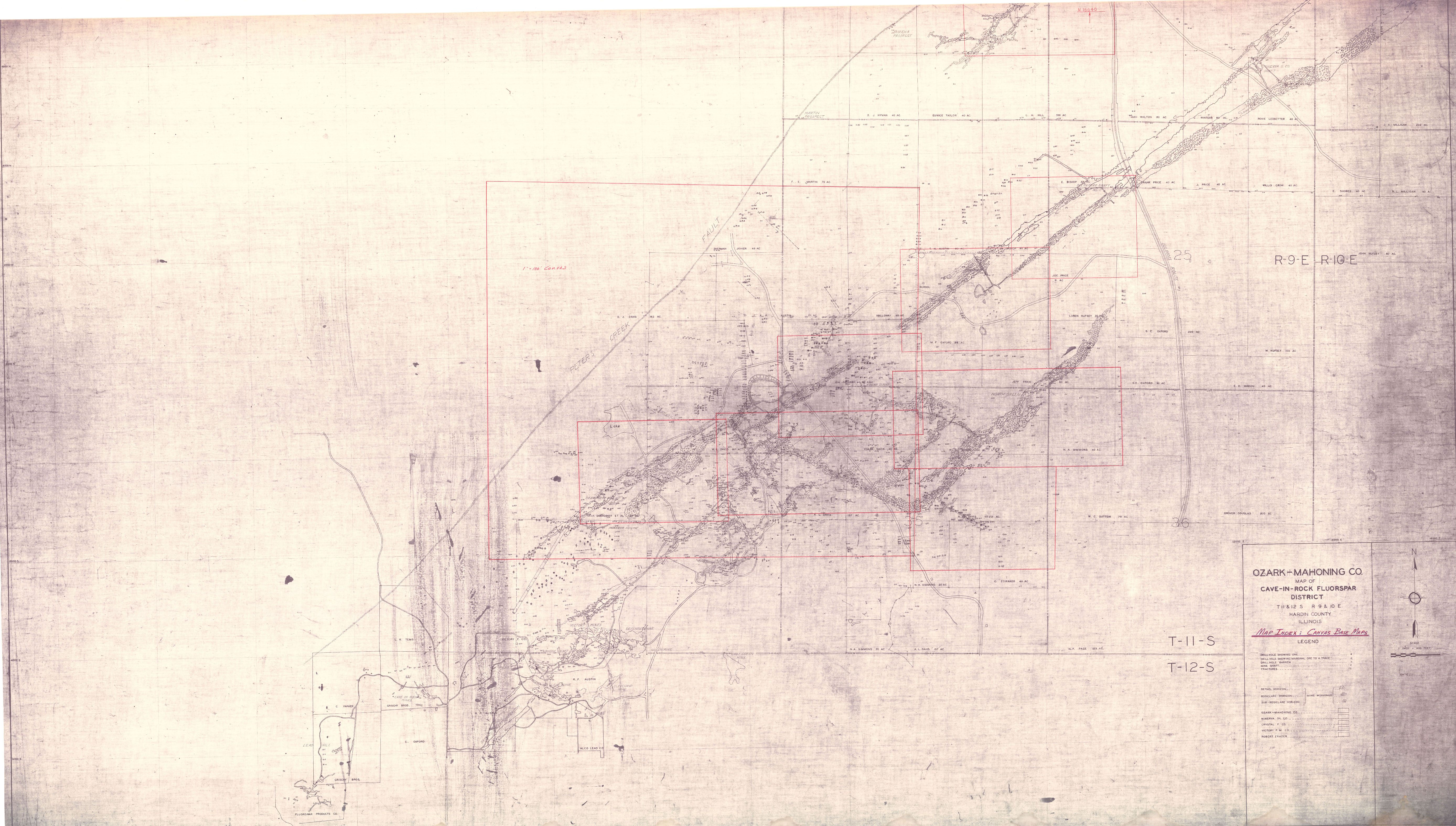
| More Info: | CaveInRockFluorsparDistrict OZM.jpg | |
| Click to download Full ResolutionThese files are true to scale and most are georegistered for gis software. File Type: Map Caption: Ozark-Mahoning Company Map of Cave-In-Rock district | ||
 These files may not be true to scale and are not georgistered. These files may not be true to scale and are not georgistered.
|
Mine Index: | 10083007 |
|---|---|---|
| Company: | Ozark-Mahoning Company | |
| Mine Name: | ||
| More Info: | CaveInRockFluorsparDistrict1956 OZM.jpg | |
| Click to download Full ResolutionThese files are true to scale and most are georegistered for gis software. File Type: Map Caption: Ozark-Mahoning Company Map of Cavie-In-Rock Fluorspar District | ||
 These files may not be true to scale and are not georgistered. These files may not be true to scale and are not georgistered.
|
Mine Index: | 10083007 |
|---|---|---|
| Company: | ||
| Mine Name: | ||
| More Info: | CaveInRockHillLedfordMinervaPlanDrill.jpg | |
| Click to download Full ResolutionThese files are true to scale and most are georegistered for gis software. File Type: Map Caption: Ozark-Mahoning Company Map of Hill-Ledford Tract and Surrounding Acreages | ||
 These files may not be true to scale and are not georgistered. These files may not be true to scale and are not georgistered.
|
Mine Index: | 10083007 |
|---|---|---|
| Company: | Ozark-Mahoning Company | |
| Mine Name: | ||
| More Info: | CaveInRockMahoning7DrillPlan.jpg | |
| Click to download Full ResolutionThese files are true to scale and most are georegistered for gis software. File Type: Map Caption: Ozark-Mahoning Company Map of Mahoning Mine Shaft No. 7
M.F. Oxford 99 Acre Tract | ||
 These files may not be true to scale and are not georgistered. These files may not be true to scale and are not georgistered.
|
Mine Index: | 10083007 |
|---|---|---|
| Company: | Ozark-Mahoning Company | |
| Mine Name: | ||
| More Info: | CaveInRockPlanDrill.jpg | |
| Click to download Full ResolutionThese files are true to scale and most are georegistered for gis software. File Type: Map Caption: Ozark-Mahoning Company Map of Cave-in-Rock Fluorspar District | ||
 These files may not be true to scale and are not georgistered. These files may not be true to scale and are not georgistered.
|
Mine Index: | 10083007 |
|---|---|---|
| Company: | Ozark-Mahoning Company | |
| Mine Name: | ||
| More Info: | Hill Ledford Plan 1961.jpg | |
| Click to download Full ResolutionThese files are true to scale and most are georegistered for gis software. File Type: Map Caption: Ozark-Mahoning Company Map of Hill-Letford Tract and surrounding acreage | ||
References
|
|
External Links
Mineral Resources Data System (MRDS) USGS Link
https://mrdata.usgs.gov/mrds/show-mrds.php?dep_id=10083007
Also referenced as 10266705