10083007: Difference between revisions
Alan.Myers (talk | contribs) No edit summary |
No edit summary |
||
| (3 intermediate revisions by 2 users not shown) | |||
| Line 9: | Line 9: | ||
|Coal_co=Ozark-Mahoning Company | |Coal_co=Ozark-Mahoning Company | ||
|Mine Name Header=M.F. Oxford No. 7 | |Mine Name Header=M.F. Oxford No. 7 | ||
|commodity_type= | |commodity_type=Metallic, Non-Metallic | ||
|commodity=Fluorspar, Lead, Silver, Zinc | |commodity=Fluorspar, Lead, Silver, Zinc | ||
|minerals_present=Barite, Calcite, Fluorite, Galena, Quartz, Sphalerite | |minerals_present=Barite, Calcite, Fluorite, Galena, Quartz, Sphalerite | ||
|Mine_Type=Underground | |Mine_Type=Underground | ||
|District=Fluorspar District | |District=Fluorspar District | ||
|Subdistrict=Cave-in-Rock Subdistrict | |||
|datemod=circa | |datemod=circa | ||
|year-start= | |year-start=1980 | ||
|year-end=9999 | |year-end=9999 | ||
|Latitude=37.5317399999999 | |Latitude=37.5317399999999 | ||
| Line 33: | Line 34: | ||
}} | }} | ||
{{NC Geology seam | {{NC Geology seam | ||
|Seam=Chesterian Series | |Seam=Lower Chesterian Series | ||
|Unit_Code=4020 | |Unit_Code=4020 | ||
}} | }} | ||
| Line 50: | Line 51: | ||
{{NC Data}} | {{NC Data}} | ||
==Mine Data== | |||
{| class="wikitable" | |||
! Ore body information | |||
|- | |||
| Dip || 07N | |||
|- | |||
| Thickness || 3M | |||
|- | |||
| Depth to top || 128M | |||
|- | |||
| Width || 76M | |||
|- | |||
| Length || 762M | |||
|- | |||
| Area || 6HA | |||
|- | |||
| Field || Value | |||
|- | |||
| Type of Orebody #1 || REPLACEMENT | |||
|- | |||
| Shape of Orebody #1 || LENTICULAR | |||
|- | |||
| Type of Orebody #2 || SHEAR ZONE | |||
|- | |||
| Type of Orebody #3 || BRECCIA FILL | |||
|- | |||
| Primary mode of Origin || HYDROTHERMAL | |||
|- | |||
| Secondary mode of Origin || CONT METASOMATIC | |||
|- | |||
| Primary Ore Control || FAULTING | |||
|- | |||
| Secondary Ore Control || BEDDING | |||
|- | |||
| Degree of Wallrock Alter. || MODERATE | |||
|- | |||
| Type of Wallrock Alter. #1 || CARBONITIZATION | |||
|- | |||
| Strike And Dip || | |||
|- | |||
| Total Surface Area (HA) || 6 | |||
|- | |||
| Date of Last Modification || 830126TRY | |||
|- | |||
| 3rd Condition of Workings || NO MINE ENTRY | |||
|- | |||
| Capacity Units || MT ORE/DAY | |||
|- | |||
| Units of Production || $/MT ORE | |||
|- | |||
| Year of Information || 1973 | |||
|} | |||
{| class="wikitable" | |||
! Workings at the site | |||
|- | |||
| Type of workings || Underground | |||
|- | |||
| Overall depth || 130M | |||
|- | |||
| Field || Value | |||
|- | |||
| MAS Development Schedule # || 1 | |||
|- | |||
| Mining Record # || 1 | |||
|- | |||
| Status of Mining Method || ESTIMATE | |||
|- | |||
| Mining Method || ROOM AND PILLAR 10-34 | |||
|- | |||
| Swell Factor || .61 | |||
|- | |||
| Percent Waste Rock || 10 | |||
|- | |||
| Hardness of Rock || SOFT NONPLASTIC WITH LITTLE WATER | |||
|- | |||
| Rock Characteristics || ONE SYSTEM OF WEAKNESS PLANES | |||
|- | |||
| Rock Support Chars. || SUPPORTING MAY BACK SLAB | |||
|- | |||
| Mine Support Chars. || POST, HEADBOARD, CAPS, ROOF BOLTS | |||
|- | |||
| 1st Condition of Workings || OPEN | |||
|- | |||
| 2nd Condition of Workings || NO MINE ENTRY | |||
|- | |||
| 3rd Condition of Workings || NO MINE ENTRY | |||
|- | |||
| Capacity Units || MT ORE/DAY | |||
|- | |||
| Units of Production || $/MT ORE | |||
|- | |||
| Year of Information || 1973 | |||
|} | |||
==References== | ==References== | ||
| Line 61: | Line 157: | ||
}} | }} | ||
{{NC mindat | {{NC mindat | ||
|MRDS_yes=No | |||
|MRDS=https://mrdata.usgs.gov/mrds/show-mrds.php?dep_id=10083007 | |MRDS=https://mrdata.usgs.gov/mrds/show-mrds.php?dep_id=10083007 | ||
}} | }} | ||
<br> | <br> | ||
[https://mrdata.usgs.gov/mrds/show-mrds.php?dep_id=10266705 Also referenced as 10266705] | [https://mrdata.usgs.gov/mrds/show-mrds.php?dep_id=10266705 Also referenced as 10266705] | ||
Latest revision as of 12:18, June 4, 2021
| Disclaimer | ||
|---|---|---|
| S-T-R | 26(SENENW)-11S-9E | |
| County: | Hardin | |
| Quadrangle: | Saline Mines | |
| District: | Fluorspar District | |
| Subdistrict: | Cave-in-Rock Subdistrict | |
Mine Index Number: 10083007
| ISGS ID: | MSHA ID: | ||
|---|---|---|---|
| MAS ID: | 170690047 | MRDS ID: | W062491 |
| Company Name: | Ozark-Mahoning Company | ||
| Mine/Site Name: | M.F. Oxford No. 7 | ||
| Active/Abandoned: | Abandoned | ||
| Start Date: | circa 1980 | End Date: | Unknown |
| Commodity Type: | Metallic, Non-Metallic | ||
| Commodity: | Fluorspar, Lead, Silver, Zinc | ||
| Minerals Present: | Galena, Barite, Calcite, Fluorite, Quartz, Sphalerite | ||
| Type of Mine: | Underground | ||
| District: | Fluorspar District | Subdistrict: | Cave-in-Rock Subdistrict |
| County: | Hardin | ||
| Section/Township/Range: | 26(SENENW)-11S-9E | ||
| Latitude,Longitude: | 37.5317399999999,-88.17559 | ||
| Unit(s) Mined: | Glen Dean Limestone, Renault Limestone, Lower Chesterian Series | ||
| Feature(s) Mined: | |||
| MRDS Link: | https://mrdata.usgs.gov/mrds/show-mrds.php?dep id=10083007 | ||
| Mindat link: | |||
Mine Data/Information
 These files may not be true to scale and are not georgistered. These files may not be true to scale and are not georgistered.
|
Mine Index: | 10083007 |
|---|---|---|
| Company: | ||
| Mine Name: | ||
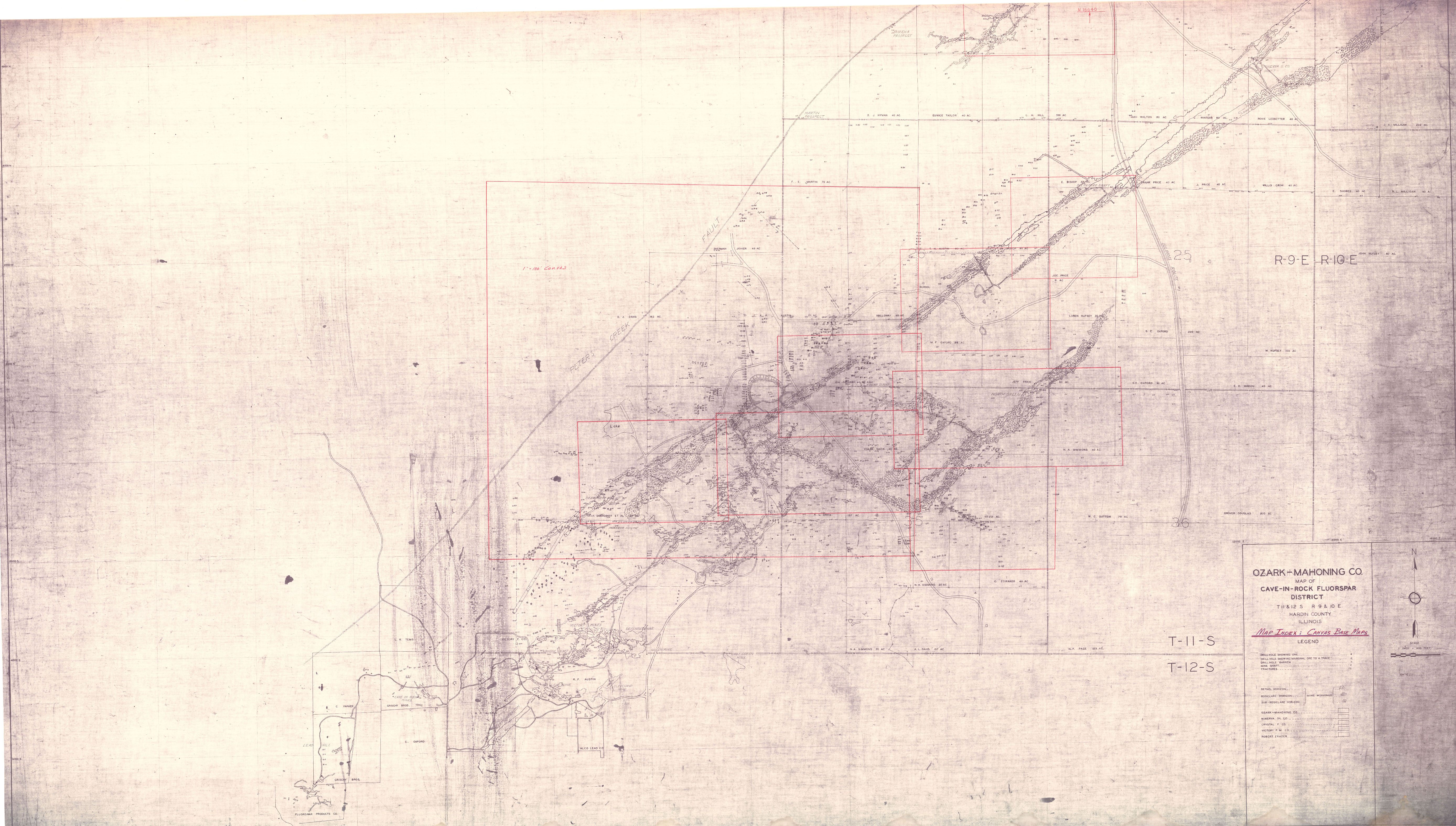
| More Info: | CaveInRockFluorsparDistrict OZM.jpg | |
| Click to download Full ResolutionThese files are true to scale and most are georegistered for gis software. File Type: Map Caption: Ozark-Mahoning Company Map of Cave-In-Rock district | ||
 These files may not be true to scale and are not georgistered. These files may not be true to scale and are not georgistered.
|
Mine Index: | 10083007 |
|---|---|---|
| Company: | Ozark-Mahoning Company | |
| Mine Name: | ||
| More Info: | CaveInRockFluorsparDistrict1956 OZM.jpg | |
| Click to download Full ResolutionThese files are true to scale and most are georegistered for gis software. File Type: Map Caption: Ozark-Mahoning Company Map of Cavie-In-Rock Fluorspar District | ||
 These files may not be true to scale and are not georgistered. These files may not be true to scale and are not georgistered.
|
Mine Index: | 10083007 |
|---|---|---|
| Company: | ||
| Mine Name: | ||
| More Info: | CaveInRockHillLedfordMinervaPlanDrill.jpg | |
| Click to download Full ResolutionThese files are true to scale and most are georegistered for gis software. File Type: Map Caption: Ozark-Mahoning Company Map of Hill-Ledford Tract and Surrounding Acreages | ||
 These files may not be true to scale and are not georgistered. These files may not be true to scale and are not georgistered.
|
Mine Index: | 10083007 |
|---|---|---|
| Company: | Ozark-Mahoning Company | |
| Mine Name: | ||
| More Info: | CaveInRockMahoning7DrillPlan.jpg | |
| Click to download Full ResolutionThese files are true to scale and most are georegistered for gis software. File Type: Map Caption: Ozark-Mahoning Company Map of Mahoning Mine Shaft No. 7
M.F. Oxford 99 Acre Tract | ||
 These files may not be true to scale and are not georgistered. These files may not be true to scale and are not georgistered.
|
Mine Index: | 10083007 |
|---|---|---|
| Company: | Ozark-Mahoning Company | |
| Mine Name: | ||
| More Info: | CaveInRockPlanDrill.jpg | |
| Click to download Full ResolutionThese files are true to scale and most are georegistered for gis software. File Type: Map Caption: Ozark-Mahoning Company Map of Cave-in-Rock Fluorspar District | ||
 These files may not be true to scale and are not georgistered. These files may not be true to scale and are not georgistered.
|
Mine Index: | 10083007 |
|---|---|---|
| Company: | Ozark-Mahoning Company | |
| Mine Name: | ||
| More Info: | Hill Ledford Plan 1961.jpg | |
| Click to download Full ResolutionThese files are true to scale and most are georegistered for gis software. File Type: Map Caption: Ozark-Mahoning Company Map of Hill-Letford Tract and surrounding acreage | ||
Mine Data
| Ore body information | |
|---|---|
| Dip | 07N |
| Thickness | 3M |
| Depth to top | 128M |
| Width | 76M |
| Length | 762M |
| Area | 6HA |
| Field | Value |
| Type of Orebody #1 | REPLACEMENT |
| Shape of Orebody #1 | LENTICULAR |
| Type of Orebody #2 | SHEAR ZONE |
| Type of Orebody #3 | BRECCIA FILL |
| Primary mode of Origin | HYDROTHERMAL |
| Secondary mode of Origin | CONT METASOMATIC |
| Primary Ore Control | FAULTING |
| Secondary Ore Control | BEDDING |
| Degree of Wallrock Alter. | MODERATE |
| Type of Wallrock Alter. #1 | CARBONITIZATION |
| Strike And Dip | |
| Total Surface Area (HA) | 6 |
| Date of Last Modification | 830126TRY |
| 3rd Condition of Workings | NO MINE ENTRY |
| Capacity Units | MT ORE/DAY |
| Units of Production | $/MT ORE |
| Year of Information | 1973 |
| Workings at the site | |
|---|---|
| Type of workings | Underground |
| Overall depth | 130M |
| Field | Value |
| MAS Development Schedule # | 1 |
| Mining Record # | 1 |
| Status of Mining Method | ESTIMATE |
| Mining Method | ROOM AND PILLAR 10-34 |
| Swell Factor | .61 |
| Percent Waste Rock | 10 |
| Hardness of Rock | SOFT NONPLASTIC WITH LITTLE WATER |
| Rock Characteristics | ONE SYSTEM OF WEAKNESS PLANES |
| Rock Support Chars. | SUPPORTING MAY BACK SLAB |
| Mine Support Chars. | POST, HEADBOARD, CAPS, ROOF BOLTS |
| 1st Condition of Workings | OPEN |
| 2nd Condition of Workings | NO MINE ENTRY |
| 3rd Condition of Workings | NO MINE ENTRY |
| Capacity Units | MT ORE/DAY |
| Units of Production | $/MT ORE |
| Year of Information | 1973 |
References
|
|
External Links
Mineral Resources Data System (MRDS) USGS Link
https://mrdata.usgs.gov/mrds/show-mrds.php?dep_id=10083007https://mrdata.usgs.gov/mrds/show-mrds.php?dep id=10083007
Also referenced as 10266705