10082977: Difference between revisions
Alan.Myers (talk | contribs) No edit summary |
Alan.Myers (talk | contribs) No edit summary |
||
| (5 intermediate revisions by the same user not shown) | |||
| Line 1: | Line 1: | ||
{{NC Sidebar Info Query}} | {{NC Sidebar Info Query}} | ||
{{NC Header | {{NC Header | ||
|checked=1st Entry | |||
|references_checked=No | |||
|Nc_active=Unknown | |Nc_active=Unknown | ||
|Mine-index=10082977 | |Mine-index=10082977 | ||
| Line 7: | Line 9: | ||
|Coal_co=Eureka Lead Company | |Coal_co=Eureka Lead Company | ||
|Mine Name Header=Eureka Lead Mine | |Mine Name Header=Eureka Lead Mine | ||
|commodity_type= | |commodity_type=Metallic, Non-Metallic | ||
|commodity=Fluorspar, Lead, Zinc | |commodity=Fluorspar, Lead, Zinc | ||
|Mine_Type=Underground | |Mine_Type=Underground | ||
|District=Fluorspar District | |District=Fluorspar District | ||
|Subdistrict=Cave-in-Rock Subdistrict | |||
|datemod=circa | |datemod=circa | ||
|year-start=1973 | |year-start=1973 | ||
| Line 33: | Line 36: | ||
PETERS CREEK FAULT TRENDS N 55 W AND DIPS TO THE NW. | PETERS CREEK FAULT TRENDS N 55 W AND DIPS TO THE NW. | ||
{{NC Geology seam | {{NC Geology seam | ||
| Line 63: | Line 58: | ||
{{NC Data}} | {{NC Data}} | ||
==Mine Data== | |||
===Shafts=== | |||
THE EAST SHAFT HAS A CROSS CUT AT THE BOTTOM EXTENDING 28 FT TO THE NW. NO DRIFTS WERE DRIVEN ON THE WEST SHAFT. | |||
====East Shaft==== | |||
Depth: 16.76M | |||
====West Shaft==== | |||
Depth: 24.38M | |||
==References== | ==References== | ||
| Line 78: | Line 81: | ||
}} | }} | ||
{{NC mindat | {{NC mindat | ||
|MRDS_yes=No | |||
|MRDS=https://mrdata.usgs.gov/mrds/show-mrds.php?dep_id=10082977 | |MRDS=https://mrdata.usgs.gov/mrds/show-mrds.php?dep_id=10082977 | ||
}} | }} | ||
<br> | <br> | ||
[https://mrdata.usgs.gov/mrds/show-mrds.php?dep_id=10217511 Also referenced as 10217511] | [https://mrdata.usgs.gov/mrds/show-mrds.php?dep_id=10217511 Also referenced as 10217511] | ||
Latest revision as of 16:20, September 16, 2021
| Disclaimer | ||
|---|---|---|
| S-T-R | 23(SWNESW)-11S-9E | |
| County: | Hardin | |
| Quadrangle: | Saline Mines | |
| District: | Fluorspar District | |
| Subdistrict: | Cave-in-Rock Subdistrict | |
Mine Index Number: 10082977
| ISGS ID: | MSHA ID: | ||
|---|---|---|---|
| MAS ID: | 170690054 | MRDS ID: | W062455 |
| Company Name: | Eureka Lead Company | ||
| Mine/Site Name: | Eureka Lead Mine | ||
| Active/Abandoned: | Unknown | ||
| Start Date: | circa 1973 | End Date: | Unknown |
| Commodity Type: | Metallic, Non-Metallic | ||
| Commodity: | Fluorspar, Lead, Zinc | ||
| Minerals Present: | |||
| Type of Mine: | Underground | ||
| District: | Fluorspar District | Subdistrict: | Cave-in-Rock Subdistrict |
| County: | Hardin | ||
| Section/Township/Range: | 23(SWNESW)-11S-9E | ||
| Latitude,Longitude: | 37.5431299999998,-88.1861399999998 | ||
| Unit(s) Mined: | Chesterian Series, Glen Dean Limestone, Renault Limestone | ||
| Feature(s) Mined: | Peters_Creek_Fault_Zone | ||
| MRDS Link: | https://mrdata.usgs.gov/mrds/show-mrds.php?dep id=10082977 | ||
| Mindat link: | |||
Discussion
THE EAST SHAFT YIELDED A LITTLE PB AND ZN ORE WHICH WAS SHIPPED. FLUORSPAR WAS FOUND ONLY IN THE WEST SHAFT AND WAS NOT ABUNDANT. GALENA WAS MODERATELY ABUNDANT, BUT SPHALERITE WAS A MINOR COMPONENT.
PETERS CREEK FAULT TRENDS N 55 W AND DIPS TO THE NW.
Mine Data/Information
 These files may not be true to scale and are not georgistered. These files may not be true to scale and are not georgistered.
|
Mine Index: | 10082977 |
|---|---|---|
| Company: | Ozark-Mahoning Company | |
| Mine Name: | ||
| More Info: | CaveInRockFluorsparDistrict1956 OZM.jpg | |
| Click to download Full ResolutionThese files are true to scale and most are georegistered for gis software. File Type: Map Caption: Ozark-Mahoning Company Map of Cavie-In-Rock Fluorspar District | ||
 These files may not be true to scale and are not georgistered. These files may not be true to scale and are not georgistered.
|
Mine Index: | 10082977 |
|---|---|---|
| Company: | Mahoning Mining Company | |
| Mine Name: | ||
| More Info: | CaveInRockPlanDrillOriginal.jpg | |
| Click to download Full ResolutionThese files are true to scale and most are georegistered for gis software. File Type: Map Caption: Mahoning Ming Company Map of Cave-in-Rock Fluorspar District | ||
 These files may not be true to scale and are not georgistered. These files may not be true to scale and are not georgistered.
|
Mine Index: | 10082977 |
|---|---|---|
| Company: | ||
| Mine Name: | ||
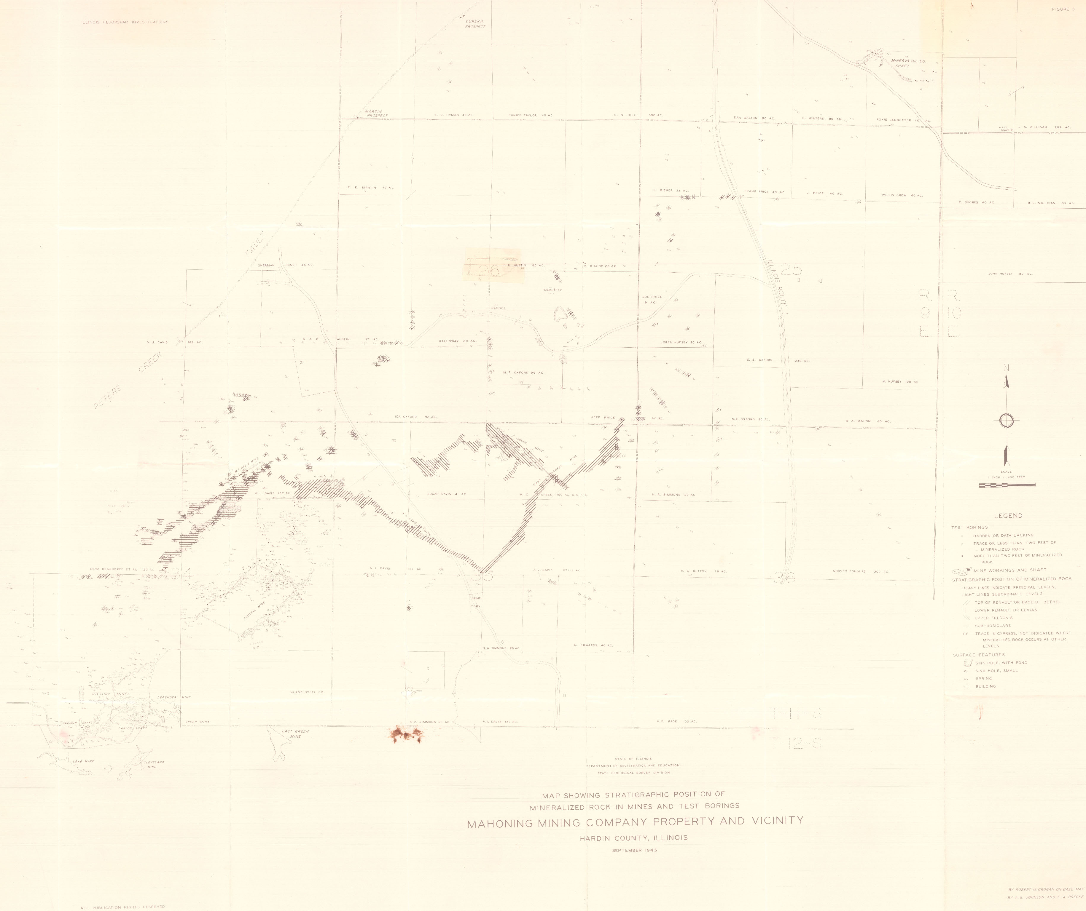
| More Info: | HardinCounty OZM GeoDrillMap.jpg | |
| Click to download Full ResolutionThese files are true to scale and most are georegistered for gis software. File Type: Map Caption: Map showing Stratigraphic Position of Mineralized rocks in Mines and test borings. Mahoning Mining Company Property and vicinity. (ISGS Map) | ||
 These files may not be true to scale and are not georgistered. These files may not be true to scale and are not georgistered.
|
Mine Index: | 10082977 |
|---|---|---|
| Company: | Ozark-Mahoning Company | |
| Mine Name: | ||
| More Info: | HillLedford DrillPlan 1967.jpg | |
| Click to download Full ResolutionThese files are true to scale and most are georegistered for gis software. File Type: Map Caption: Ozark Mahoning company Hill Ledford Mine west exploration area | ||
Mine Data
Shafts
THE EAST SHAFT HAS A CROSS CUT AT THE BOTTOM EXTENDING 28 FT TO THE NW. NO DRIFTS WERE DRIVEN ON THE WEST SHAFT.
East Shaft
Depth: 16.76M
West Shaft
Depth: 24.38M
References
|
|
|
External Links
Mineral Resources Data System (MRDS) USGS Link
https://mrdata.usgs.gov/mrds/show-mrds.php?dep_id=10082977https://mrdata.usgs.gov/mrds/show-mrds.php?dep id=10082977
Also referenced as 10217511