Carroll
Alan.Myers (talk | contribs) |
Alan.Myers (talk | contribs) |
||
| Line 11: | Line 11: | ||
! [https://wikiimage.isgs.illinois.edu/ilmines/webfiles/mines-series/mines-maps/pdf-files/mines-map-carroll.pdff Calhoun County Mine Map] | ! [https://wikiimage.isgs.illinois.edu/ilmines/webfiles/mines-series/mines-maps/pdf-files/mines-map-carroll.pdff Calhoun County Mine Map] | ||
|} | |} | ||
==Coal Resources== | ==Coal Resources== | ||
Revision as of 17:27, February 23, 2022
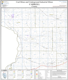
Coal Mines
This county map displays coal mines and/or underground industrial mines. If coal mining has occured in this county, a directory of additional information about these coal mines is included with the map. Buffer regions for industrial mineral underground mines were incorporated into this map due to limited information regarding these mines. The size of the buffer region is dependent on the uncertainty or inaccuracy of the mine location. For more information regarding industrial mines please contact the ISGS Industrial Minerals Section. The county maps also display quadrangle boundaries for which the ISGS has completed studies. Scale 1:100,000. PDF file.
The accompanying coal mine directory provides basic information about the coal mines. PDF file.
|
| Calhoun County Mine Map |
|---|
Coal Resources
There are no coal resources maps for Carroll County.
Coal Logs
There are no coal logs for Carrol County.