Category:Ewing-Quadrangle: Difference between revisions
Alan.Myers (talk | contribs) (Created page with "{{County-Page}}") |
Alan.Myers (talk | contribs) No edit summary |
||
| Line 1: | Line 1: | ||
{{County- | __NOTOC__ | ||
==Mining in the Ewing Quadrangle== | |||
The oldest mining known to have taken place in the Ewing Quadrangle is a small area in the southwestern corner, extending from a large mine on the West Frankfort Quadrangle. The Middle Fork Mine ([[0139|mine index 139}}) worked in the Herrin Coal, which was over 6 feet thick. Thick Herrin Coal extends over the remainder of the quadrangle, at a depth of 700 to 800 feet. The M-Class No. 1 Mine (mine index 1047) began operation as a longwall mine in 2010. | |||
==Map and Directory PDF Download== | |||
[https://wikiimage.isgs.illinois.edu/ilmines/webfiles/topo-mines/Ewing.pdf Coal Mines In Illinois Ewing Quadrangle]</br> | |||
==Mines that Appear on the Ewing Quadrangle== | |||
{{#css: | |||
#mw-subcategories {display: none} | |||
#mw-pages {display: none} | |||
#mw-category-media {display: none} | |||
}} | |||
{{#ask:[[Category:Ewing-Quadrangle]] | |||
[[:+]] | |||
[[Unlocated::No]] | |||
|?combined = Coal Company, Mine Name | |||
|?County | |||
|format=datatables|limit=1500|link=all|sort=Mine Index|order=asc|headers=plain|mainlabel=Mine Index|searchlabel=... further results|class=sortable wikitable smwtable|sep=<br>|Default='''Mines for this quadrangle have not been entered into Ilmines-Wiki see download above for more information'''}} | |||
==Unlocated Mines== | |||
===Franklin County=== | |||
{{#ask:[[Category:Franklin-County]] | |||
[[:+]] | |||
[[Unlocated::Yes]] | |||
|?combined = Coal Company, Mine Name | |||
|?City | |||
|format=datatables|limit=1500|link=all|sort=Mine Index|order=asc|headers=plain|mainlabel=Mine Index|searchlabel=... further results|default=There are no known Unlocated mines in this county |class=sortable wikitable smwtable|sep=<br>}} | |||
{{DISPLAYTITLE:Ewing Quadrangle}} | |||
Latest revision as of 15:00, October 26, 2022
Mining in the Ewing Quadrangle
The oldest mining known to have taken place in the Ewing Quadrangle is a small area in the southwestern corner, extending from a large mine on the West Frankfort Quadrangle. The Middle Fork Mine ([[0139|mine index 139}}) worked in the Herrin Coal, which was over 6 feet thick. Thick Herrin Coal extends over the remainder of the quadrangle, at a depth of 700 to 800 feet. The M-Class No. 1 Mine (mine index 1047) began operation as a longwall mine in 2010.
Map and Directory PDF Download
Coal Mines In Illinois Ewing Quadrangle
Mines that Appear on the Ewing Quadrangle
Unlocated Mines
Franklin County
Pages in category "Ewing-Quadrangle"
The following 6 pages are in this category, out of 6 total.
Media in category "Ewing-Quadrangle"
The following 3 files are in this category, out of 3 total.
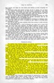 M0139 coalreport 1914.pdf 825 × 1,264; 568 KB
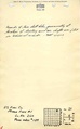 M0139 minenotes.pdf 739 × 1,193, 19 pages; 5.3 MB
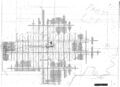 M0139.jpg 3,390 × 2,452; 1.76 MB
