Carroll
Alan.Myers (talk | contribs) (Created page with "__NOTOC__{{#css:#ca-key1 { display:none!important; } }} ==Coal Mines== {| class="wikitable" style="background-color:#ffffff;" |- | <html><a href="https://wikiimage.isgs.illin...") |
Alan.Myers (talk | contribs) No edit summary |
||
| (6 intermediate revisions by the same user not shown) | |||
| Line 2: | Line 2: | ||
}} | }} | ||
==Coal Mines== | ==Coal Mines== | ||
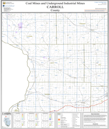
This county map displays coal mines and/or underground industrial mines. If coal mining has occurred in this county, a directory of additional information about these coal mines is included with the map. Buffer regions for industrial mineral underground mines were incorporated into this map due to limited information regarding these mines. The size of the buffer region is dependent on the uncertainty or inaccuracy of the mine location. For more information regarding industrial mines please contact the ISGS Industrial Minerals Section. The county maps also display quadrangle boundaries for which the ISGS has completed studies. Scale 1:100,000. PDF file. | |||
The accompanying coal mine directory provides basic information about the coal mines. PDF file. | |||
{| class="wikitable" style="background-color:#ffffff;" | {| class="wikitable" style="background-color:#ffffff;" | ||
|- | |- | ||
| <html><a href="https://wikiimage.isgs.illinois.edu/ilmines/webfiles/mines-series/mines-maps/pdf-files/mines-map-carroll.pdf"><img style="max-width: 250px; max-height: 250px;" src="https://wikiimage.isgs.illinois.edu/ilmines/webfiles/mines-series/mines-maps/images/mines-carroll.gif"></a></html> | | <html><a href="https://wikiimage.isgs.illinois.edu/ilmines/webfiles/mines-series/mines-maps/pdf-files/mines-map-carroll.pdf"><img style="max-width: 250px; max-height: 250px;" src="https://wikiimage.isgs.illinois.edu/ilmines/webfiles/mines-series/mines-maps/images/mines-carroll.gif"></a></html> | ||
|- | |- | ||
! [https://wikiimage.isgs.illinois.edu/ilmines/webfiles/mines-series/mines-maps/pdf-files/mines-map-carroll.pdff | ! [https://wikiimage.isgs.illinois.edu/ilmines/webfiles/mines-series/mines-maps/pdf-files/mines-map-carroll.pdff Carroll County Mine Map] | ||
|} | |} | ||
===ILMINES WIKI=== | ===ILMINES WIKI=== | ||
The links below contain much of the same information as the downloadable directories above. But has links to additional information such as mine map downloads, additional Mine Notes downloads, and other data.<br> | |||
[[:Category:Carroll-County|Carroll County]]<br> | |||
==Coal Resources== | ==Coal Resources== | ||
There are no coal resources maps for Carroll County. | There are no coal resources maps for Carroll County. | ||
| Line 19: | Line 19: | ||
==Coal Logs== | ==Coal Logs== | ||
There are no coal logs for Carrol County. | There are no coal logs for Carrol County. | ||
[[Category:{{SUBPAGENAME}}-County]]{{#set:County_Coal_Page=Yes}} | [[Category:{{SUBPAGENAME}}-County]]{{#set:County_Coal_Page=Yes}}[[Category:County Coal Data]] | ||
Latest revision as of 16:52, January 12, 2024
Coal Mines
This county map displays coal mines and/or underground industrial mines. If coal mining has occurred in this county, a directory of additional information about these coal mines is included with the map. Buffer regions for industrial mineral underground mines were incorporated into this map due to limited information regarding these mines. The size of the buffer region is dependent on the uncertainty or inaccuracy of the mine location. For more information regarding industrial mines please contact the ISGS Industrial Minerals Section. The county maps also display quadrangle boundaries for which the ISGS has completed studies. Scale 1:100,000. PDF file.
The accompanying coal mine directory provides basic information about the coal mines. PDF file.
|
| Carroll County Mine Map |
|---|
ILMINES WIKI
The links below contain much of the same information as the downloadable directories above. But has links to additional information such as mine map downloads, additional Mine Notes downloads, and other data.
Carroll County
Coal Resources
There are no coal resources maps for Carroll County.
Coal Logs
There are no coal logs for Carrol County.