Carroll
Coal Mines
|
| Calhoun County Mine Map |
|---|
Quadrangle Coal Mine Maps and Directories located in Carrol County
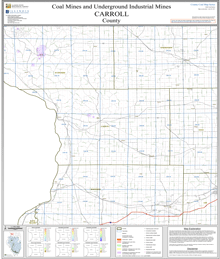
These selected 7.5-minute quadrangle maps are available online as PDF versions and show active and abandoned mines and their known extent on a topographic map base which includes township, range, and section lines and surface features such as roads, towns, lakes, and rivers. The mines are color-coded by mining method and the relative precision and completeness of the source map used for the mine boundary are indicated. Scale 1:24,000. Accompanying each map is a directory that gives a brief history of mining on the quadrangle and lists for each mine the location of mine opening and tipples; the name, thickness, and depth of seams mined; production history; geologic problems reported; company names; mine names and numbers; type of mine; years operated; coal seam mined; and mine location.
Brussels Quadrangle Map and Directory
ILMINES WIKI
Coal Resources
There are no coal resources maps for Carroll County.
Coal Logs
There are no coal logs for Carrol County.