Ewing Quadrangle
Revision as of 15:00, October 26, 2022 by Alan.Myers (talk | contribs)
Mining in the Ewing Quadrangle
The oldest mining known to have taken place in the Ewing Quadrangle is a small area in the southwestern corner, extending from a large mine on the West Frankfort Quadrangle. The Middle Fork Mine ([[0139|mine index 139}}) worked in the Herrin Coal, which was over 6 feet thick. Thick Herrin Coal extends over the remainder of the quadrangle, at a depth of 700 to 800 feet. The M-Class No. 1 Mine (mine index 1047) began operation as a longwall mine in 2010.
Map and Directory PDF Download
Coal Mines In Illinois Ewing Quadrangle
Mines that Appear on the Ewing Quadrangle
Unlocated Mines
Franklin County
Pages in category "Ewing Quadrangle"
The following 6 pages are in this category, out of 6 total.
Media in category "Ewing Quadrangle"
The following 3 files are in this category, out of 3 total.
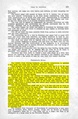 M0139 coalreport 1914.pdf 825 × 1,264; 568 KB
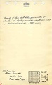 M0139 minenotes.pdf 739 × 1,193, 19 pages; 5.3 MB
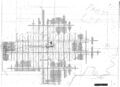 M0139.jpg 3,390 × 2,452; 1.76 MB
