Bond
Alan.Myers (talk | contribs) |
Alan.Myers (talk | contribs) No edit summary |
||
| (16 intermediate revisions by the same user not shown) | |||
| Line 2: | Line 2: | ||
}} | }} | ||
==Coal Mines== | ==Coal Mines== | ||
This county map displays coal mines and/or underground industrial mineral mines. If coal mining has | This county map displays coal mines and/or underground industrial mineral mines. If coal mining has occurred in this county, a directory of additional information about these coal mines is included with the map. Buffer regions for industrial mineral mines were incorporated into this map due to limited information regarding these mines. The size of the buffer region is dependent on the uncertainty or inaccuracy of the mine location. For more information regarding industrial mineral mines please contact the ISGS Industrial Minerals Section. The county maps also display quadrangle boundaries for which the ISGS has completed studies. Scale 1:100,000. PDF file. | ||
The accompanying coal mine directory provides basic information about the coal mines. PDF file. | The accompanying coal mine directory provides basic information about the coal mines. PDF file. | ||
| Line 10: | Line 10: | ||
| <html><a href="https://wikiimage.isgs.illinois.edu/ilmines/webfiles/mines-series/mines-directories/pdf-files/mines-directory-bond.pdf"><img style="max-width: 250px; max-height: 250px;" src="https://wikiimage.isgs.illinois.edu/ilmines/webfiles/mines-series/mines-directories/images/mines-dir.gif"></a></html> | | <html><a href="https://wikiimage.isgs.illinois.edu/ilmines/webfiles/mines-series/mines-directories/pdf-files/mines-directory-bond.pdf"><img style="max-width: 250px; max-height: 250px;" src="https://wikiimage.isgs.illinois.edu/ilmines/webfiles/mines-series/mines-directories/images/mines-dir.gif"></a></html> | ||
|- | |- | ||
! [https://wikiimage.isgs.illinois.edu/ilmines/webfiles/mines-series/mines-maps/pdf-files/mines-map-bond.pdf Herrin Bond County Mine Map] !![https://wikiimage.isgs.illinois.edu/ilmines/webfiles/mines-series/mines-directories/pdf-files/mines-directory-bond.pdf Bond County Mine Directory | ! [https://wikiimage.isgs.illinois.edu/ilmines/webfiles/mines-series/mines-maps/pdf-files/mines-map-bond.pdf Herrin Bond County Mine Map] !![https://wikiimage.isgs.illinois.edu/ilmines/webfiles/mines-series/mines-directories/pdf-files/mines-directory-bond.pdf Bond County Mine Directory] | ||
|} | |} | ||
===ILMINES WIKI=== | |||
The links below contain much of the same information as the downloadable directories above. But has links to additional information such as mine map downloads, additional Mine Notes downloads, and other data.<br> | |||
[[:Category:Bond-County|Bond County]]<br> | |||
==Coal Resources== | ==Coal Resources== | ||
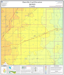
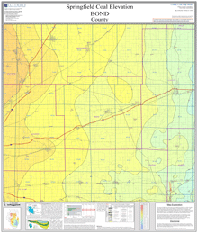
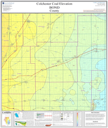
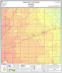
County structural elevation, depth, and thickness maps. Scale 1:100,000. PDF files. | County structural elevation, depth, and thickness maps. Scale 1:100,000. PDF files. | ||
===Elevation=== | ===Elevation=== | ||
{| class="wikitable" style="background-color:#ffffff;" | {| class="wikitable" style="background-color:#ffffff;" | ||
|- | |- | ||
|<html><a href="https://wikiimage.isgs.illinois.edu/ilmines/webfiles/danville-series/danville-elev/pdf-files/danville-elev-bond.pdf"><img style="max-width: 250px; max-height: 250px;" src="https://wikiimage.isgs.illinois.edu/ilmines/webfiles/danville-series/danville-elev/images/danville-elev-bond.gif"></a></html> | |<html><a href="https://wikiimage.isgs.illinois.edu/ilmines/webfiles/danville-series/danville-elev/pdf-files/danville-elev-bond.pdf"><img style="max-width: 250px; max-height: 250px;" src="https://wikiimage.isgs.illinois.edu/ilmines/webfiles/danville-series/danville-elev/images/danville-elev-bond.gif"></a></html> | ||
|<html><a href="https://wikiimage.isgs.illinois.edu/ilmines/webfiles/herrin-series/herrin-elev/pdf-files/herrin-elev-bond.pdf"><img style="max-width: 250px; max-height: 250px;" src="https://wikiimage.isgs.illinois.edu/ilmines/webfiles/herrin-series/herrin-elev/images/herrin-elev-bond.gif"></a></html> | |<html><a href="https://wikiimage.isgs.illinois.edu/ilmines/webfiles/herrin-series/herrin-elev/pdf-files/herrin-elev-bond.pdf"><img style="max-width: 250px; max-height: 250px;" src="https://wikiimage.isgs.illinois.edu/ilmines/webfiles/herrin-series/herrin-elev/images/herrin-elev-bond.gif"></a></html> | ||
|- | |- | ||
! [https://wikiimage.isgs.illinois.edu/ilmines/webfiles/danville-series/danville-elev/pdf-files/danville-elev-bond.pdf Danville Coal Map] | ![https://wikiimage.isgs.illinois.edu/ilmines/webfiles/danville-series/danville-elev/pdf-files/danville-elev-bond.pdf Danville Coal Map] | ||
! [https://wikiimage.isgs.illinois.edu/ilmines/webfiles/herrin-series/herrin-elev/pdf-files/herrin-elev-bond.pdf Herrin Coal Map] | ![https://wikiimage.isgs.illinois.edu/ilmines/webfiles/herrin-series/herrin-elev/pdf-files/herrin-elev-bond.pdf Herrin Coal Map] | ||
|} | |||
{|class="wikitable" style="background-color:#ffffff;" | |||
|- | |- | ||
|<html><a href="https://wikiimage.isgs.illinois.edu/ilmines/webfiles/springfield-series/springfield-elev/pdf-files/springfield-elev-bond.pdf"><img style="max-width: 250px; max-height: 250px;" src="https://wikiimage.isgs.illinois.edu/ilmines/webfiles/springfield-series/springfield-elev/images/springfield-elev-bond.gif"></a></html> | |<html><a href="https://wikiimage.isgs.illinois.edu/ilmines/webfiles/springfield-series/springfield-elev/pdf-files/springfield-elev-bond.pdf"><img style="max-width: 250px; max-height: 250px;" src="https://wikiimage.isgs.illinois.edu/ilmines/webfiles/springfield-series/springfield-elev/images/springfield-elev-bond.gif"></a></html> | ||
| Line 28: | Line 33: | ||
|- | |- | ||
! [https://wikiimage.isgs.illinois.edu/ilmines/webfiles/springfield-series/springfield-elev/pdf-files/springfield-elev-bond.pdf Springfield Coal Map] | ! [https://wikiimage.isgs.illinois.edu/ilmines/webfiles/springfield-series/springfield-elev/pdf-files/springfield-elev-bond.pdf Springfield Coal Map] | ||
! [https://wikiimage.isgs.illinois.edu/ilmines/webfiles/colchester-series/colchester-elev/pdf-files/colchester-elev-bond.pdf | ! [https://wikiimage.isgs.illinois.edu/ilmines/webfiles/colchester-series/colchester-elev/pdf-files/colchester-elev-bond.pdf Colchester Coal Map] | ||
|} | |} | ||
===Depth=== | ===Depth=== | ||
{| class="wikitable" style="background-color:#ffffff;" | {| class="wikitable" style="background-color:#ffffff;border-collapse:collapse; border-spacing:7px;" | ||
|- | |- | ||
|<html><a href="https://wikiimage.isgs.illinois.edu/ilmines/webfiles/danville-series/danville-depth/pdf-files/danville-depth-bond.pdf"><img style="max-width: 250px; max-height: 250px;" src="https://wikiimage.isgs.illinois.edu/ilmines/webfiles/danville-series/danville-depth/images/danville-depth-bond.gif"></a></html> | |<html><a href="https://wikiimage.isgs.illinois.edu/ilmines/webfiles/danville-series/danville-depth/pdf-files/danville-depth-bond.pdf"><img style="max-width: 250px; max-height: 250px;" src="https://wikiimage.isgs.illinois.edu/ilmines/webfiles/danville-series/danville-depth/images/danville-depth-bond.gif"></a></html> | ||
| Line 39: | Line 44: | ||
! [https://wikiimage.isgs.illinois.edu/ilmines/webfiles/danville-series/danville-depth/pdf-files/Danville-depth-bond.pdf Danville Coal Map] | ! [https://wikiimage.isgs.illinois.edu/ilmines/webfiles/danville-series/danville-depth/pdf-files/Danville-depth-bond.pdf Danville Coal Map] | ||
! [https://wikiimage.isgs.illinois.edu/ilmines/webfiles/herrin-series/herrin-depth/pdf-files/herrin-depth-bond.pdf Herrin Coal Map] | ! [https://wikiimage.isgs.illinois.edu/ilmines/webfiles/herrin-series/herrin-depth/pdf-files/herrin-depth-bond.pdf Herrin Coal Map] | ||
|- | |||
|} | |||
{| class="wikitable" style="background-color:#ffffff;border-collapse:collapse; border-spacing:7px;" | |||
|- | |- | ||
|<html><a href="https://wikiimage.isgs.illinois.edu/ilmines/webfiles/springfield-series/springfield-depth/pdf-files/springfield-depth-bond.pdf"><img style="max-width: 250px; max-height: 250px;" src="https://wikiimage.isgs.illinois.edu/ilmines/webfiles/springfield-series/springfield-depth/images/springfield-depth-bond.gif"></a></html> | |<html><a href="https://wikiimage.isgs.illinois.edu/ilmines/webfiles/springfield-series/springfield-depth/pdf-files/springfield-depth-bond.pdf"><img style="max-width: 250px; max-height: 250px;" src="https://wikiimage.isgs.illinois.edu/ilmines/webfiles/springfield-series/springfield-depth/images/springfield-depth-bond.gif"></a></html> | ||
| Line 48: | Line 56: | ||
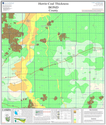
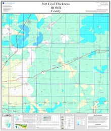
===Thickness=== | ===Thickness=== | ||
{| class="wikitable" style="background-color:#ffffff;border-collapse:collapse; border-spacing:7px;" | |||
|- | |||
|<html><a href="https://wikiimage.isgs.illinois.edu/ilmines/webfiles/danville-series/danville-thk/pdf-files/danville-thk-bond.pdf"><img style="max-width: 250px; max-height: 250px;" src="https://wikiimage.isgs.illinois.edu/ilmines/webfiles/danville-series/danville-thk/images/danville-thk-bond.gif"></a></html> | |||
|<html><a href="https://wikiimage.isgs.illinois.edu/ilmines/webfiles/herrin-series/herrin-thk/pdf-files/herrin-thk-bond.pdf"><img style="max-width: 250px; max-height: 250px;" src="https://wikiimage.isgs.illinois.edu/ilmines/webfiles/herrin-series/herrin-thk/images/herrin-thk-bond.gif"></a></html> | |||
|- | |||
![https://wikiimage.isgs.illinois.edu/ilmines/webfiles/danville-series/danville-thk/pdf-files/danville-thk-bond.pdf Danville Coal Map] | |||
![https://wikiimage.isgs.illinois.edu/ilmines/webfiles/herrin-series/herrin-thk/pdf-files/herrin-thk-bond.pdf Herrin Coal Map] | |||
|} | |||
{| class="wikitable" style="background-color:#ffffff;border-collapse:collapse; border-spacing:7px;" | |||
|- | |||
|<html><a href="https://wikiimage.isgs.illinois.edu/ilmines/webfiles/springfield-series/springfield-thk/pdf-files/springfield-thk-bond.pdf"><img style="max-width: 250px; max-height: 250px;" src="https://wikiimage.isgs.illinois.edu/ilmines/webfiles/springfield-series/springfield-thk/images/springfield-thk-bond.gif"></a></html> | |||
|<html><a href="https://wikiimage.isgs.illinois.edu/ilmines/webfiles/colchester-series/colchester-thk/pdf-files/colchester-thk-bond.pdf"><img style="max-width: 250px; max-height: 250px;" src="https://wikiimage.isgs.illinois.edu/ilmines/webfiles/colchester-series/colchester-thk/images/colchester-thk-bond.gif"></a></html> | |||
|- | |||
![https://wikiimage.isgs.illinois.edu/ilmines/webfiles/springfield-series/springfield-thk/pdf-files/springfield-thk-bond.pdf Springfield Coal Map] | |||
![https://wikiimage.isgs.illinois.edu/ilmines/webfiles/colchester-series/colchester-thk/pdf-files/colchester-thk-bond.pdf Colchester Coal Map] | |||
|} | |||
{| class="wikitable" style="background-color:#ffffff;border-collapse:collapse; border-spacing:7px;" | |||
|- | |||
|<html><a href="https://wikiimage.isgs.illinois.edu/ilmines/webfiles/net-coal-series/net-coal-thk/pdf-files/net-coal-thk-bond.pdf"><img style="max-width: 250px; max-height: 250px;" src="https://wikiimage.isgs.illinois.edu/ilmines/webfiles/net-coal-series/net-coal-thk/images/net-coal-thk-bond.gif"></a></html> | |||
|- | |||
![https://wikiimage.isgs.illinois.edu/ilmines/webfiles/net-coal-series/net-coal-thk/pdf-files/net-coal-thk-bond.pdf Net-coal Coal Map] | |||
|} | |||
===Sulfur=== | ===Sulfur=== | ||
{| class="wikitable" style="background-color:#ffffff;border-collapse:collapse; border-spacing:7px;" | |||
|- | |||
|<html><a href="https://wikiimage.isgs.illinois.edu/ilmines/webfiles/danville-series/danville-sulf/pdf-files/danville-sulf-bond.pdf"><img style="max-width: 250px; max-height: 250px;" src="https://wikiimage.isgs.illinois.edu/ilmines/webfiles/danville-series/danville-sulf/images/danville-sulf-bond.gif"></a></html> | |||
|<html><a href="https://wikiimage.isgs.illinois.edu/ilmines/webfiles/herrin-series/herrin-sulf/pdf-files/herrin-sulf-bond.pdf"><img style="max-width: 250px; max-height: 250px;" src="https://wikiimage.isgs.illinois.edu/ilmines/webfiles/herrin-series/herrin-sulf/images/herrin-sulf-bond.gif"></a></html> | |||
|- | |||
![https://wikiimage.isgs.illinois.edu/ilmines/webfiles/danville-series/danville-sulf/pdf-files/danville-sulf-bond.pdf Danville Coal Map] | |||
![https://wikiimage.isgs.illinois.edu/ilmines/webfiles/herrin-series/herrin-sulf/pdf-files/herrin-sulf-bond.pdf herrin Coal Map] | |||
|} | |||
{| class="wikitable" style="background-color:#ffffff;border-collapse:collapse; border-spacing:7px;" | |||
|- | |||
|<html><a href="https://wikiimage.isgs.illinois.edu/ilmines/webfiles/springfield-series/springfield-sulf/pdf-files/springfield-sulf-bond.pdf"><img style="max-width: 250px; max-height: 250px;" src="https://wikiimage.isgs.illinois.edu/ilmines/webfiles/springfield-series/springfield-sulf/images/springfield-sulf-bond.gif"></a></html> | |||
|- | |||
![https://wikiimage.isgs.illinois.edu/ilmines/webfiles/springfield-series/springfield-sulf/pdf-files/springfield-sulf-bond.pdf springfield Coal Map] | |||
|} | |||
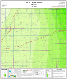
===Chlorine=== | ===Chlorine=== | ||
{| class="wikitable" style="background-color:#ffffff;" | |||
|- | |||
|<html><a href="https://wikiimage.isgs.illinois.edu/ilmines/webfiles/herrin-series/herrin-chlr/pdf-files/herrin-chlr-bond.pdf"><img style="max-width: 250px; max-height: 250px;" src="https://wikiimage.isgs.illinois.edu/ilmines/webfiles/herrin-series/herrin-chlr/images/herrin-chlr-bond.gif"></a></html> | |||
|- | |||
![https://wikiimage.isgs.illinois.edu/ilmines/webfiles/herrin-series/herrin-chlr/pdf-files/herrin-chlr-bond.pdf Herrin Coal Map] | |||
|} | |||
'''On demand plots available for these maps!''' If you are unable to make your own large size plots from these PDF's we also offer an on demand plot for individual maps from our publication and sales office—for cost of the plot and handling. Please contact the ISGS at (217) 244-2414, or email at [mailto:sales@prairie.illinois.edu sales@prairie.illinois.edu](link sends e-mail) for more information on purchasing plots and other details. | '''On demand plots available for these maps!''' If you are unable to make your own large size plots from these PDF's we also offer an on demand plot for individual maps from our publication and sales office—for cost of the plot and handling. Please contact the ISGS at (217) 244-2414, or email at [mailto:sales@prairie.illinois.edu sales@prairie.illinois.edu](link sends e-mail) for more information on purchasing plots and other details. | ||
| Line 62: | Line 110: | ||
The PDF file contains non-confidential coal log descriptions from the Coal Section's stratigraphic database in the county listed. Coal logs are sorted by township/range and section. | The PDF file contains non-confidential coal log descriptions from the Coal Section's stratigraphic database in the county listed. Coal logs are sorted by township/range and section. | ||
You can [[Illinois Coal Resource Shapefiles|download]] the raw .dbf files from which the stratigraphic database is derived (if such files are what you require; most users will only want the PDF files). | You can '''[[Illinois Coal Resource Shapefiles|download]]''' the raw .dbf files from which the stratigraphic database is derived (if such files are what you require; most users will only want the PDF files). | ||
Each PDF file has a summary sheet that contains an overview of data and geology for the county. Each coal log has a "header" element that contains location information, log type, log source and other information. For each log, North American Datum 1983 (NAD83) Longitude/Latitude coordinates in decimal degrees are provided as well as a legal description which uses the Public Land Survey System (PLSS). | Each PDF file has a summary sheet that contains an overview of data and geology for the county. Each coal log has a "header" element that contains location information, log type, log source and other information. For each log, North American Datum 1983 (NAD83) Longitude/Latitude coordinates in decimal degrees are provided as well as a legal description which uses the Public Land Survey System (PLSS). | ||
Beneath the header is geology information for that data point. The Coal Section stratigraphic database from which this .PDF file is derived is a multi-project database which contains drill hole and outcrop descriptions of Pennsylvanian stratigraphy in Illinois. Consequently, the level of detail and accuracy in the data and their interpretation vary (sometimes widely) with the geologist, project type, or original data source. Multiple descriptions of a particular location may be present. Note that both the coal stratigraphic database and this .PDF listing are only a subset of the total amount of data available from the ISGS Geologic Records Library archives, and reflect only coal-specific data and interpretations of past and present Coal Section geologists. They are not a comprehensive listing of all data that may be available from the ISGS. | Beneath the header is geology information for that data point. The Coal Section stratigraphic database from which this .PDF file is derived is a multi-project database which contains drill hole and outcrop descriptions of Pennsylvanian stratigraphy in Illinois. Consequently, the level of detail and accuracy in the data and their interpretation vary (sometimes widely) with the geologist, project type, or original data source. Multiple descriptions of a particular location may be present. Note that both the coal stratigraphic database and this .PDF listing are only a subset of the total amount of data available from the ISGS Geologic Records Library archives, and reflect only coal-specific data and interpretations of past and present Coal Section geologists. They are not a comprehensive listing of all data that may be available from the ISGS. | ||
[[Category:Bond-County]]{{#set:County_Coal_Page=Yes}}{{#set:Coal_Seam_elev=Danville}}{{#set:Coal_Seam_elev=Herrin}}{{#set:Coal_Seam_elev=Springfield}}{{#set:Coal_Seam_elev=Colchester}}{{#set:Coal_Seam_depth=Danville}}{{#set:Coal_Seam_depth=Herrin}}{{#set:Coal_Seam_depth=Springfield}}{{#set:Coal_Seam_depth=Colchester}}{{#set:Coal_Seam_thick=Danville}}{{#set:Coal_Seam_thick=Herrin}}{{#set:Coal_Seam_thick=Springfield}}{{#set:Coal_Seam_thick=Colchester}}{{#set:Net Coal Thick=Yes}}{{#set:Coal_Seam_sulf=Danville}}{{#set:Coal_Seam_sulf=Herrin}}{{#set:Coal_Seam_sulf=Springfield}}{{#set:Coal_Seam_chlr=Herrin}}[[Category:County Coal Data]] | |||
Latest revision as of 16:34, January 12, 2024
Coal Mines
This county map displays coal mines and/or underground industrial mineral mines. If coal mining has occurred in this county, a directory of additional information about these coal mines is included with the map. Buffer regions for industrial mineral mines were incorporated into this map due to limited information regarding these mines. The size of the buffer region is dependent on the uncertainty or inaccuracy of the mine location. For more information regarding industrial mineral mines please contact the ISGS Industrial Minerals Section. The county maps also display quadrangle boundaries for which the ISGS has completed studies. Scale 1:100,000. PDF file.
The accompanying coal mine directory provides basic information about the coal mines. PDF file.

|

|
| Herrin Bond County Mine Map | Bond County Mine Directory |
|---|
ILMINES WIKI
The links below contain much of the same information as the downloadable directories above. But has links to additional information such as mine map downloads, additional Mine Notes downloads, and other data.
Bond County
Coal Resources
County structural elevation, depth, and thickness maps. Scale 1:100,000. PDF files.
Elevation
|

|
| Danville Coal Map | Herrin Coal Map |
|---|
|
|
| Springfield Coal Map | Colchester Coal Map |
|---|
Depth
|

|
| Danville Coal Map | Herrin Coal Map |
|---|

|

|
| Springfield Coal Map | Colchester Coal Map |
|---|
Thickness

|
|
| Danville Coal Map | Herrin Coal Map |
|---|

|

|
| Springfield Coal Map | Colchester Coal Map |
|---|
|
| Net-coal Coal Map |
|---|
Sulfur

|

|
| Danville Coal Map | herrin Coal Map |
|---|
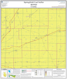
|
| springfield Coal Map |
|---|
Chlorine
|
| Herrin Coal Map |
|---|
On demand plots available for these maps! If you are unable to make your own large size plots from these PDF's we also offer an on demand plot for individual maps from our publication and sales office—for cost of the plot and handling. Please contact the ISGS at (217) 244-2414, or email at sales@prairie.illinois.edu(link sends e-mail) for more information on purchasing plots and other details.
Coal Logs
The PDF file contains non-confidential coal log descriptions from the Coal Section's stratigraphic database in the county listed. Coal logs are sorted by township/range and section.
You can download the raw .dbf files from which the stratigraphic database is derived (if such files are what you require; most users will only want the PDF files).
Each PDF file has a summary sheet that contains an overview of data and geology for the county. Each coal log has a "header" element that contains location information, log type, log source and other information. For each log, North American Datum 1983 (NAD83) Longitude/Latitude coordinates in decimal degrees are provided as well as a legal description which uses the Public Land Survey System (PLSS).
Beneath the header is geology information for that data point. The Coal Section stratigraphic database from which this .PDF file is derived is a multi-project database which contains drill hole and outcrop descriptions of Pennsylvanian stratigraphy in Illinois. Consequently, the level of detail and accuracy in the data and their interpretation vary (sometimes widely) with the geologist, project type, or original data source. Multiple descriptions of a particular location may be present. Note that both the coal stratigraphic database and this .PDF listing are only a subset of the total amount of data available from the ISGS Geologic Records Library archives, and reflect only coal-specific data and interpretations of past and present Coal Section geologists. They are not a comprehensive listing of all data that may be available from the ISGS.