Ozark-Mahoning Mine Maps
Alan.Myers (talk | contribs) No edit summary |
Alan.Myers (talk | contribs) |
||
| (12 intermediate revisions by the same user not shown) | |||
| Line 5: | Line 5: | ||
==Instructions== | ==Instructions== | ||
'''The GIS map below will not return site or mine specific information, all the maps that cover the geographic area where you clicked will be return. You will need to inspect the map to see if it fits your needs.'''<br> | '''The GIS map below will not return site or mine specific information, all the maps that cover the geographic area where you clicked will be return. You will need to inspect the map to see if it fits your needs.'''<br> | ||
Hovering your cursor over the map will generate a floating popup box, clicking on the map will fix this popup to the lower left hand corner of the map.<br> | |||
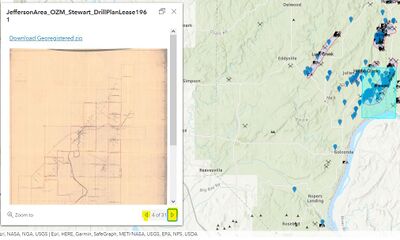
After clicking, use the navigation arrows in the popup (lower right hand corner...see image below) to cycle thru the available maps.<br> | |||
[[File:OZM nav.JPG|400px]]<br> | [[File:OZM nav.JPG|400px]]<br> | ||
The thumbnail image linked in the popup, when click, will take you to a lower resolution image.<br> | The thumbnail image linked in the popup, when click, will take you to a lower resolution image.<br> | ||
For the full resolution and georegistered image, click the "Download Georegistered zip" link | For the full resolution and georegistered image, click the "Download Georegistered zip" link.<br> | ||
To see the outlines of all the maps, click the "eye" next to "Map Outlines" in the layer menu. | |||
==Ozark-Mahoning Maps== | ==Ozark-Mahoning Maps== | ||
| Line 18: | Line 20: | ||
|border=0 | |border=0 | ||
}} | }} | ||
==Log and Cross Section Downloads== | |||
[https://uofi.box.com/s/g1i9xipvtvdvwtd7amws9psxz710qfwx Click here to View or Download individual logs/cross sections.] | |||
Latest revision as of 09:28, February 25, 2022
Instructions
The GIS map below will not return site or mine specific information, all the maps that cover the geographic area where you clicked will be return. You will need to inspect the map to see if it fits your needs.
Hovering your cursor over the map will generate a floating popup box, clicking on the map will fix this popup to the lower left hand corner of the map.
After clicking, use the navigation arrows in the popup (lower right hand corner...see image below) to cycle thru the available maps.
The thumbnail image linked in the popup, when click, will take you to a lower resolution image.
For the full resolution and georegistered image, click the "Download Georegistered zip" link.
To see the outlines of all the maps, click the "eye" next to "Map Outlines" in the layer menu.
Ozark-Mahoning Maps
Mobile Device Friendly Map Link
Log and Cross Section Downloads
Click here to View or Download individual logs/cross sections.

