Farmersville Quadrangle
Mining in the Farmersville Quadrangle
A great deal of mining by the Freeman Coal Company (later Freeman United Coal Mining Company) took place in the Farmersville Quadrangle. The Herrin Coal was thicker here than in the Virden South Quadrangle to the west. The Freeman mines, Crown No. 1 (mine index 707), Crown II Mine (mine index 933), and Crown III Mine (mine index 996) operated after 1974, and were more prepared to deal with the issues that occur in thick coal in deep mines.
The Farmersville No. 1 Mine (mine index 3004) had thick coal, and was located near town. It is likely that the short operating span (only 8 years, from 1907 to 1915) was due to the lack of railroad connections and an inability to expand their market, with larger mines in Belleville, Collinsville and Mt. Olive to the south and well-established mines in the vicinity of Springfield to the north.
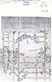
Some fractures and faulting were noted in the Herrin Coal, with displacement of up to 2 feet. A sandstone channel was present in Crown No. 1 Mine (mine index 707) and between Crown No. 1 Mine and Crown III Mine (mine index 996).
Map and Directory PDF Download
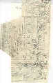
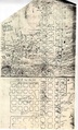
Coal Mines In Illinois Farmersville Quadrangle
Mines that Appear on the Farmersville Quadrangle
Unlocated Mines
Montgomery County
Macoupin County
Pages in category "Farmersville Quadrangle"
The following 11 pages are in this category, out of 11 total.
Media in category "Farmersville Quadrangle"
The following 17 files are in this category, out of 17 total.
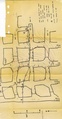
 M0067 fieldnotes.pdf 754 × 1,200, 2 pages; 370 KB
 M0067 minenotes.pdf 731 × 1,202, 29 pages; 7.17 MB
 M0707 minenotes.pdf 737 × 1,193, 66 pages; 17.78 MB
 M0933 minenotes Part01.pdf 764 × 1,208, 65 pages; 29.79 MB
 M0933 minenotes Part02.pdf 700 × 1,181, 126 pages; 29.75 MB
 M0933 minenotes Part03.pdf 695 × 1,066, 121 pages; 29.83 MB
 M0933 minenotes Part04.pdf 977 × 1,514, 103 pages; 29.65 MB
 M0933 minenotes Part05.pdf 1,235 × 2,041, 80 pages; 29.82 MB
 M0933 minenotes Part06.pdf 1,243 × 2,389, 90 pages; 29.89 MB
 M0933 minenotes Part07.pdf 743 × 1,179, 93 pages; 29.93 MB
 M0933 minenotes Part08.pdf 718 × 797, 93 pages; 29.35 MB
 M0933 minenotes Part09.pdf 752 × 883, 93 pages; 29.67 MB
 M0933 minenotes Part10.pdf 737 × 1,168, 105 pages; 29.97 MB
 M0933 minenotes Part11.pdf 1,112 × 1,508, 6 pages; 2.4 MB
 M0996 minenotes.pdf 737 × 1,202, 131 pages; 37.77 MB
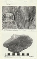
 M3004 coalreport1908.pdf 629 × 970; 75 KB
 M3004 minenotes.pdf 737 × 1,193, 6 pages; 1.38 MB