3596: Difference between revisions
Alan.Myers (talk | contribs) m (Text replacement - "OFallon" to "O'Fallon") |
No edit summary |
||
| Line 10: | Line 10: | ||
|county1=St. Clair | |county1=St. Clair | ||
|quad1=O'Fallon | |quad1=O'Fallon | ||
|year-start= | |datemod=before | ||
|year-start=1874 | |||
|year-end=1895 | |year-end=1895 | ||
|Latitude=38.5239279480001 | |Latitude=38.5239279480001 | ||
| Line 60: | Line 61: | ||
|depth=80-130 | |depth=80-130 | ||
|thick-ave=6.0-6.5 | |thick-ave=6.0-6.5 | ||
|mining-method=RP | |||
}} | }} | ||
===Geological Problems Reported=== | ===Geological Problems Reported=== | ||
| Line 165: | Line 167: | ||
{{Annotated bibliography header}} | {{Annotated bibliography header}} | ||
{{Annotated bibliography | {{Annotated bibliography | ||
|bibliography=Coal Reports - Production, ownership, years of operation, seam, depth, thickness. | |bibliography=Coal Reports - Production, ownership, years of operation, seam, depth, thickness, mining method. | ||
}} | }} | ||
{{Annotated bibliography | {{Annotated bibliography | ||
| Line 171: | Line 173: | ||
}} | }} | ||
{{Annotated bibliography | {{Annotated bibliography | ||
|bibliography=Microfilm map, (WPA), document 351022, reel 03134, frame 100 - Shaft locations, mine outline. | |bibliography=Microfilm map, (WPA), document 351022, reel 03134, frame 100, WPA map of T1N-R8W - Shaft locations, mine outline. | ||
}} | }} | ||
{{Annotated bibliography | {{Annotated bibliography | ||
Revision as of 11:58, October 1, 2020
Mine Index Number: 3596
| Company Name: | Bruggeman and Hortman Coal Company | ||
|---|---|---|---|
| Mine Name: | Braun's Mine | ||
| Start Date: | before 1874 | End Date: | 1895 |
| Type of Mine: | Underground | ||
| Total acres shown: | 137 Numerous mines operated in this vicinity. No source maps are available for the individual mines; a general area of mining designates the area. | ||
| Acres after map date: | General Area of mining acres shown: | ||
Shaft, Slope, Drift or Tipple Location(s)
| Type | County | Township-Range | Section | Part Section |
|---|
| Shaft | St. Clair | 1N 8W | 22 | NE SW NW |
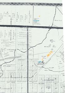
| Bruggeman and Hortman shaft | St. Clair | 1N 8W | 22 | SW SW NW The 1874 Atlas of St. Clair County indicated this shaft was Brauch & Hessebaum. |
| Hortman shaft | St. Clair | 1N 8W | 22 | SE NW NW |
| C. Reinecke shaft | St. Clair | 1N 8W | 22 | NW SW NE |
| C. Reinecke air shaft | St. Clair | 1N 8W | 22 | NW SW NE |
Geology
| Thickness (ft) | |||||
|---|---|---|---|---|---|
| Seam | Depth (ft) | Min | Max | Ave | Mining Method |
| Herrin | 80-130 | 6.0-6.5 | RP |
Geological Problems Reported
Production
| Company | Mine Name | Date | Production (tons) |
| Conrad Reinecke | Reinecke No. 1 | pre1882-1886 | 192,665 Production prior to 1882 unknown. The Coal Report of 1882 indicates 30 acres mined. |
| Consolidated Coal Company of St. Louis | Reinecke No. 1 | 1886-1896 | 117,012 |
| Hortsman and Brother | Hortsman | pre1882-1882 | 7,000 Production prior to 1882 unknown. The Coal Report of 1882 indicates 12 acres mined. The March 1884 Sanborn- Perris Insurance map shows both Bruggeman & Hortman shafts in this area, as well as C. Reinecke. |
| Bruggeman | Bruggeman | 1882-1883 | 8,900 |
| Bruggeman and Bloom | Bruggeman and Bloom | 1883-1884 | 7,529 |
| F. J. Bruggeman | Bruggeman | 1884-1885 | 7,141 |
| Bruggeman | Bruggeman No. 1 and No. 2 | 1885-1886 | 6,627 |
| Bruggeman and Hortman | (B. and H.) No. 1 and No. 2 | 1886-1887 | 28,000 |
| Bruggeman and Hortman | Bruggeman and Hortman No. 1 | 1887-1889 | 8,870 |
| Bruggeman and Hortman | Bruggeman and Hortman No. 2 | 1887-1889 | 37,000 |
| Bruggeman and Hortman | Bruggeman and Hortman No. 3 | 1888-1889 | 2,000 |
| F. J. Bruggeman | Bruggeman | 1889-1894 | 42,233 |
| Charles Hartman | Hartman No. 1 | 1889-1895 | 156,050 |
Production Notes
Coal Report production (if available)
Sources of Data
| Source Map | Map Date | Original Scale | Digitized Scale | Map Type |
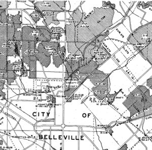
| Microfilm, document 351022 | 10-10-1891 | 1:12000 | 1:24828 | Secondary source |
Annotated Bibliography (Data source - brief description of information)
| Coal Reports - Production, ownership, years of operation, seam, depth, thickness, mining method. |
| Directory of Illinois Coal Mines (St. Clair County) - Mine names, mine index, ownership, years of operation. |
| Microfilm map, (WPA), document 351022, reel 03134, frame 100, WPA map of T1N-R8W - Shaft locations, mine outline. |
| 1874 Atlas of St. Clair County - Shaft locations. |
Mine Notes
Mine Images
Photographs


