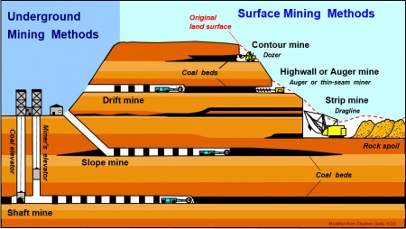
Mining Type
SHAFT, SLOPE, DRIFT OR TIPPLE LOCATIONS
 |
| Image Credit: Stephen Greb, Kentucky Geological Survey, University of Kentucky |
Locations of all known former entry points to underground mines or the location of coal cleaning, tipple, and shipping equipment used by the mine’s facility are listed.
The location is described in terms of county, township and range (Twp-Rge), section, and location within the section by quarters. NE SW NW, for instance, would describe the location in the northeast quarter of the southwest quarter of the northwest quarter. When sections are irregular in size, the quarters remain the same size and are oriented (or “registered”) from the southeast corner of the section.
Approximate footage from the section lines (FEL = from east line, FNL = from north line, for example) is given when that information is known; this indicates a surveyed location and is not derived from maps.
Entry points are also plotted on the map and coded for the type of entry or tipple. Click here to see symbols used on the Map
A mine opening may have had many purposes during the life of the mine. Old hoist shafts are often later used for air and escape shafts; this information is included in the directory when known. The tipple for underground mines was generally located near the main shaft or slope. At surface mines, coal was sometimes hauled to a central tipple several miles from the mine pit.
