Interpreting the Map
The accompanying map shows the location of coal mines that are known to be present in Illinois.
Mining Type and Method
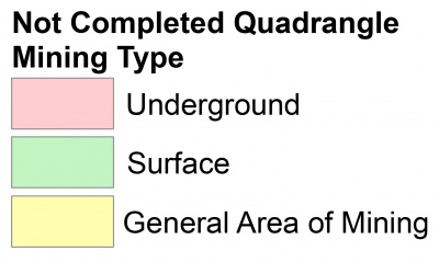
The mine type is indicated on the map by pattern color: green represents surface mines; red and yellow represent underground mines.
The red patterns are used for areas of underground mining that are documented by a primary or secondary source map. A yellow pattern is used for cases where no map of the mine workings is available, but a general area of mining can be inferred from property maps or production figures. The patterns indicate the main mining methods used in underground mines. The methods are (1) room and pillar and (2) high extraction. The method used gives some indication of the amount and pattern of coal extraction within each mined area, and has some influence on the timing and type of subsidence that can occur over a mine.
Map scale larger than 1:100,000
Map scale smaller than 1:100,000
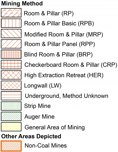
See Mining Method for more info about Mining Methods
Source Maps
Mine outlines depicted on the map are, whenever possible, based on maps made from original mine surveys. The process of compiling and digitizing the quadrangle map may produce errors of less than 200 feet in the location of
mine boundaries. Larger errors of 500 feet or more are possible for mines that have incomplete or inaccurate source maps.
Because of the extreme complexity of some mine maps, detailed features of mined areas have been omitted. The digitized mine boundary includes the exterior boundary of all rooms or entries that were at least 80 feet wide or
protruded 500 feet from the main mining area. Unmined areas between mines are shown if they are at least 80 feet wide; unmined blocks of coal within mines are shown if they are at least 400 feet on each side. Original source maps should be consulted when precise information on mine boundaries or interior features is needed.
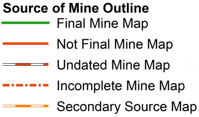
The mine summary sheet lists the source maps used to determine each mine outline. The completeness of map sources is indicated on the map by a line symbol at the mine boundary. Source maps are organized in five categories.
Final mine map
- The mine outline was digitized from an original map made from mine surveys conducted within a few months after production ceased. The date of the map and the last reported production are listed on the summarysheet.
Not a final map
- The mine is currently active or the mine outline was made from a map based on mine surveys conducted more than few months before production ceased. This implies the actual mined-out area is probably larger than the outline on the map. The mine summary sheet indicated the dates of source maps and the last reported production, as well as the approximate tonnage mined between these two dates (if the mine is abandoned). The summary sheet also lists the approximate acreage mined since the date of the map and, in some cases, indicates the area where additional mining may have taken place. This latter information is determined by locating on the map the active faces relative to probable boundaries of the mine property.
Undated map
- The source map was undated, so it may or may not be based on a final mine survey. When sufficient data are available, the probable acreage of the mined area is estimated from reported production, average seam thickness and a recovery rate comparable to other mines in the area. This information is listed in the summary sheet for the mine.
Incomplete map
- The source map did not show the entire mine. The summary sheet indicates the missing part of the mine map and the acreage of the unmapped area, which is estimated from the amount of coal known to have been produced from the mine.
Secondary source map
- The original mine map was not found so the outline shown was determined from secondary sources (e.g., outlines from small-scale regional maps published in other reports). The summary sheet describes the secondary sources.
Points and Labels
Points
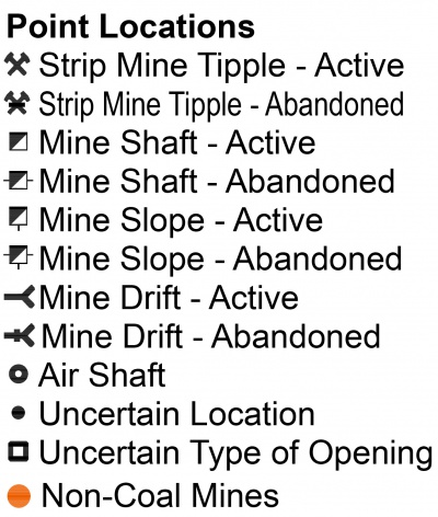
The locations of all known mine openings (shafts, slopes, and drifts) and surface mine tipples are plotted on the map.
Tipples are areas where coal was cleaned, stockpiled, and loaded for shipping.
Only openings or tipples are plotted for mines without source maps. If the precise locations of these features are unknown, a special symbol is used to indicate the approximate location of the mine.
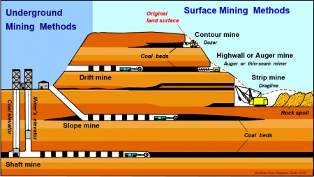 |
| Image Credit: Stephen Greb, Kentucky Geological Survey, University of Kentucky |
Labels
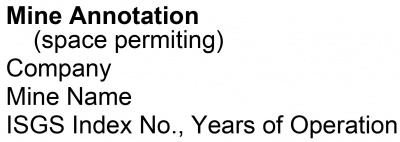
Each mine on the map is labeled with the names of the mine and operating company, ISGS mine index number, and
years of operation (if known) if space permits. A seam designation is given on maps where more than one seam was
mined. For a mine that operated under more than one name, only the most recent name is generally given. When a
mine changed names or ownership shortly before closing, an earlier name is listed. All company and mine names are
listed on the mine summary sheet in the directory, under the production history segment.

