File:M3692 wpa 17 19n11w.jpg: Difference between revisions
No edit summary |
No edit summary |
||
| Line 1: | Line 1: | ||
{{Image | |||
|File name=M3692 wpa 17 19n11w.jpg | |||
|Mine-index=3692, 6541 | |||
|Mine-index2=3687 | |||
|Mine-index3=3706 | |||
|Coal_co=M. C. Wilkinson | |||
|Mine_name=Wilkinson No. 2 Mine | |||
|Map Date=5-6-1903 | |||
|Map Type=WPA | |||
|Map Scale=1:12000 | |||
|Map Status=Secondary source | |||
|Map ID=T19N-R11W | |||
|county1=Vermilion | |||
|quad1=Danville SW | |||
|Image Notes=The original georegistered version of the map was lost. The newly georegistered map does not match the original exactly but illustrates why the WPA was necessary for placement of the microfilm. | |||
|Image Used For=Positioning microfilm map | |||
}} | |||
Revision as of 11:44, March 29, 2021
| Mine Index(s): | 3687, 3692, 3706, 6541,3687 ,3706 |
| Mine Company: | M. C. Wilkinson |
| Mine Name | Wilkinson No. 2 Mine |
| Map Date | 5-6-1903 |
| Map Scale | 1:12000 |
| Map Type microfilm/company/wpa/quade | WPA |
| Map Status final,not final, secondary | Secondary source |
| ID Number | T19N-R11W |
| Used For | Positioning microfilm map |
| Notes | The original georegistered version of the map was lost. The newly georegistered map does not match the original exactly but illustrates why the WPA was necessary for placement of the microfilm. |
| Image Credit | |
File history
Click on a date/time to view the file as it appeared at that time.
| Date/Time | Thumbnail | Dimensions | User | Comment | |
|---|---|---|---|---|---|
| current | 11:40, March 29, 2021 | 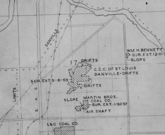 | 540 × 441 (59 KB) | Cheri (talk | contribs) |
You cannot overwrite this file.