4489: Difference between revisions
(Created page with "{{Sidebar Info Query}} {{Header |checked=1st Entry |unlocated=No |shown_on_map=Yes |Mine-index=4489 |Coal_co={{#info: The years of operation, ownership and production are unkn...") |
No edit summary |
||
| Line 1: | Line 1: | ||
{{Sidebar Info Query}} | {{Sidebar Info Query}} | ||
{{Header | {{Header | ||
|checked= | |checked=Checked OK | ||
|unlocated=No | |unlocated=No | ||
|shown_on_map=Yes | |shown_on_map=Yes | ||
|reason_nsm=This small surface mine was later enlarged by the Will Scarlet Mine (mine index 697). | |||
|Mine-index=4489 | |Mine-index=4489 | ||
|Coal_co={{#info: The years of operation, ownership and production are unknown.|note}} | |Coal_co={{#info: The years of operation, ownership and production are unknown.|note}} | ||
|mine_type=Surface | |mine_type=Surface | ||
|mined-out-area=None | |mined-out-area=None | ||
|county1=Williamson | |county1=Williamson | ||
|quad1=Carrier Mills | |quad1=Carrier Mills | ||
Revision as of 12:37, January 11, 2022
Mine Index Number: 4489
| Company Name: | The years of operation, ownership and production are unknown. | ||
|---|---|---|---|
| Mine Name: | |||
| Start Date: | Unknown | End Date: | Unknown |
| Type of Mine: | Surface | ||
| Total acres shown: | None | ||
| Acres after map date: | General Area of mining acres shown: | ||
|
This small surface mine was later enlarged by the Will Scarlet Mine (mine index 697). | |||
Property "Company" (as page type) with input value "The years of operation, ownership and production are unknown." contains invalid characters or is incomplete and therefore can cause unexpected results during a query or annotation process.
Shaft, Slope, Drift or Tipple Location(s)
| Type | County | Township-Range | Section | Part Section |
|---|
| Pit | Williamson | 10S 4E | 15 | SE |
Geology
| Thickness (ft) | |||||
|---|---|---|---|---|---|
| Seam | Depth (ft) | Min | Max | Ave | Mining Method |
| Dekoven | 20 | 1.67 | Surface |
| Davis | 21 (with 9' interburden) | 1.33 and 2.0 | Surface |
Geological Problems Reported
Production
| Company | Mine Name | Date | Production (tons) |
Production Notes
Coal Report production (if available)
Sources of Data
| Source Map | Map Date | Original Scale | Digitized Scale | Map Type |
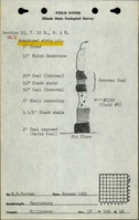
| ISGS field notes (W. E. Parham) | 1961 | (text only) | 1:24000 Point plotted onto 1:24,000 USGS topographic map and digitized. | Secondary source |
Annotated Bibliography (Data source - brief description of information)
| Directory of Illinois Coal Mines (Williamson County) - Mine names, mine index, ownership, years of operation. |
| ISGS field notes (Williamson County) - Mine type, mine location, seam, depth, thickness. |
Mine Notes
Mine Images
Photographs