4108: Difference between revisions
(Created page with "{{Sidebar Info Query}} {{Header |checked=1st Entry |unlocated=No |shown_on_map=Yes |Mine-index=4108 |Coal_co=Unknown |county1=Williamson |quad1=Carrier Mills |Latitude=0 |Long...") |
No edit summary |
||
| (2 intermediate revisions by 2 users not shown) | |||
| Line 1: | Line 1: | ||
{{Sidebar Info Query}} | {{Sidebar Info Query}} | ||
{{Header | {{Header | ||
|checked= | |checked=Checked OK | ||
|unlocated=No | |unlocated=No | ||
|shown_on_map=Yes | |shown_on_map=Yes | ||
|Mine-index=4108 | |Mine-index=4108 | ||
|Coal_co=Unknown | |Coal_co=Unknown | ||
|Mine Name Header=Chaney's Coal Bank | |||
|mine_type=Underground | |||
|mined-out-area=None | |||
|indicated=No | |||
|county1=Williamson | |county1=Williamson | ||
|quad1=Carrier Mills | |quad1=Carrier Mills | ||
|Latitude= | |datemod=Before | ||
|Longitude= | |year-start=1916 | ||
|year-end=9999 | |||
|Latitude=37.64035682 | |||
|Longitude=-88.71373608 | |||
|Zoom=15 | |Zoom=15 | ||
}} | }} | ||
| Line 16: | Line 23: | ||
{{Shaft locations header}} | {{Shaft locations header}} | ||
{{Shaft locations | {{Shaft locations | ||
|shaft_type=Drift | |||
|County=Williamson | |County=Williamson | ||
|Town-Range=10S 4E | |Town-Range=10S 4E | ||
| Line 26: | Line 34: | ||
{{Geology seam | {{Geology seam | ||
|Seam=Davis | |Seam=Davis | ||
|thick-ave=3.33 | |||
|mining-method=Underground | |||
}} | }} | ||
===Geological Problems Reported=== | ===Geological Problems Reported=== | ||
| Line 32: | Line 42: | ||
{{Production header}} | {{Production header}} | ||
{{Production | |||
|Mine-Name=Chaney Coal Bank | |||
|Date=circa 1916 | |||
|Sum=No | |||
}} | |||
===Production Notes=== | ===Production Notes=== | ||
| Line 40: | Line 55: | ||
{{Source Map | {{Source Map | ||
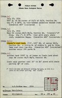
|Source Map=ISGS field notes (A. D. Brokaw) | |Source Map=ISGS field notes (A. D. Brokaw) | ||
|Map Date=1916 | |Map Date=7-21-1916 | ||
|Original Scale=1:62500 | |||
|Digitized Scale=1:62500 | |||
|Map Type=Secondary source | |||
}} | }} | ||
{{Annotated bibliography header}} | {{Annotated bibliography header}} | ||
{{Annotated bibliography | |||
|bibliography=ISGS field notes (Williamson County) - Mine name, mine type, mine location, thickness. | |||
}} | |||
==Mine Notes== | ==Mine Notes== | ||
Latest revision as of 14:17, March 18, 2024
Mine Index Number: 4108
| Company Name: | Unknown | ||
|---|---|---|---|
| Mine Name: | Chaney's Coal Bank | ||
| Start Date: | Before 1916 | End Date: | Unknown |
| Type of Mine: | Underground | ||
| Total acres shown: | None | ||
| Acres after map date: | General Area of mining acres shown: | ||
Shaft, Slope, Drift or Tipple Location(s)
| Type | County | Township-Range | Section | Part Section |
|---|
| Drift | Williamson | 10S 4E | 24 | SE NW NE |
Geology
| Thickness (ft) | |||||
|---|---|---|---|---|---|
| Seam | Depth (ft) | Min | Max | Ave | Mining Method |
| Davis | 3.33 | Underground |
Geological Problems Reported
Production
| Company | Mine Name | Date | Production (tons) |
| Chaney Coal Bank | circa 1916 | ||
Production Notes
Coal Report production (if available)
Sources of Data
| Source Map | Map Date | Original Scale | Digitized Scale | Map Type |
| ISGS field notes (A. D. Brokaw) | 7-21-1916 | 1:62500 | 1:62500 | Secondary source |
Annotated Bibliography (Data source - brief description of information)
| ISGS field notes (Williamson County) - Mine name, mine type, mine location, thickness. |
Mine Notes
Mine Images

Photographs