4497: Difference between revisions
Alan.Myers (talk | contribs) No edit summary |
No edit summary |
||
| Line 1: | Line 1: | ||
{{Sidebar Info Query}} | {{Sidebar Info Query}} | ||
{{Header | {{Header | ||
|checked= | |checked=Checked OK | ||
|unlocated=No | |unlocated=No | ||
|shown_on_map=No | |shown_on_map=No | ||
| Line 7: | Line 7: | ||
|Mine-index=4497 | |Mine-index=4497 | ||
|Coal_co=Unknown | |Coal_co=Unknown | ||
|Mine Name Header=Unknown Mine | |||
|mine_type=Underground | |||
|mined-out-area=None | |||
|indicated=No | |||
|county1=Williamson | |county1=Williamson | ||
|quad1=Carrier Mills | |quad1=Carrier Mills | ||
|year-start=9999 | |year-start=9999 | ||
|year-end= | |datemodend=Before | ||
|year-end=1925 | |||
|Latitude=0 | |Latitude=0 | ||
|Longitude=0 | |Longitude=0 | ||
Revision as of 11:31, March 21, 2024
Mine Index Number: 4497
| Company Name: | Unknown | ||
|---|---|---|---|
| Mine Name: | Unknown Mine | ||
| Start Date: | Unknown | End Date: | Before 1925 |
| Type of Mine: | Underground | ||
| Total acres shown: | None | ||
| Acres after map date: | General Area of mining acres shown: | ||
|
Not Shown On Map. Not shown on accompanying map because of later surface mining | |||
Shaft, Slope, Drift or Tipple Location(s)
| Type | County | Township-Range | Section | Part Section |
|---|
| Williamson | 10S 4E | 13 | NW NW SW |
Geology
| Thickness (ft) | |||||
|---|---|---|---|---|---|
| Seam | Depth (ft) | Min | Max | Ave | Mining Method |
| Davis | 2.75 |
Geological Problems Reported
Production
| Company | Mine Name | Date | Production (tons) |
Production Notes
Coal Report production (if available)
Sources of Data
| Source Map | Map Date | Original Scale | Digitized Scale | Map Type |
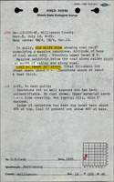
| ISGS field notes (G. H. Cady) | 7-14-1925 |
Annotated Bibliography (Data source - brief description of information)
Mine Notes
Mine Images
Photographs