7278: Difference between revisions
No edit summary |
No edit summary |
||
| Line 32: | Line 32: | ||
{{Geology seam header}} | {{Geology seam header}} | ||
{{Geology seam | |||
|Seam=Gentry | |||
|mining-method=Unknown | |||
}} | |||
===Geological Problems Reported=== | ===Geological Problems Reported=== | ||
Latest revision as of 11:44, April 16, 2024
Mine Index Number: 7278
| Company Name: | Unknown | ||
|---|---|---|---|
| Mine Name: | Unknown Mine | ||
| Start Date: | Unknown | End Date: | Before 1961 |
| Type of Mine: | Unknown | ||
| Total acres shown: | None | ||
| Acres after map date: | General Area of mining acres shown: | ||
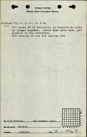
Shaft, Slope, Drift or Tipple Location(s)
| Type | County | Township-Range | Section | Part Section |
|---|
| Mines | Johnson | 11S 2E | 25 | W ½ |
Geology
| Thickness (ft) | |||||
|---|---|---|---|---|---|
| Seam | Depth (ft) | Min | Max | Ave | Mining Method |
| Gentry | Unknown |
Geological Problems Reported
Production
| Company | Mine Name | Date | Production (tons) |
Production Notes
Old mines southeast of Goreville, “just pockets in the sandstone”.
Coal Report production (if available)
Sources of Data
| Source Map | Map Date | Original Scale | Digitized Scale | Map Type |
| ISGS field note (W. E. Parham) | 1961 | 1:62500 | 1:62500 | Secondary source |
Annotated Bibliography (Data source - brief description of information)
| ISGS field notes (Johnson County) - Mine location. |
Mine Notes
Mine Images
Photographs