Mine Index Number: 10069406
| ISGS ID:
|
9020
|
MSHA ID:
|
|
| MAS ID:
|
|
MRDS ID:
|
W006923
|
| Company Name:
|
Yingling Mining Company
|
| Mine/Site Name:
|
Rose Creek Fluorspar Mines, Conley, Smee Shafts
|
| Active/Abandoned:
|
Abandoned
|
| Start Date:
|
Unknown
|
End Date:
|
Unknown
|
| Commodity Type:
|
Metallic, Non-Metallic
|
| Commodity:
|
Fluorspar, Lead, Zinc
|
| Minerals Present:
|
Galena, Fluorine
|
| Type of Mine:
|
Unknown
|
| District:
|
Fluorspar District
|
Subdistrict:
|
Rose Creek Subdistrict
|
| County:
|
Hardin
|
| Section/Township/Range:
|
11-11S-7E
|
| Latitude,Longitude:
|
37.57424,-88.40782
|
| Unit(s) Mined:
|
Chesterian Series, Glen Dean Limestone, Renault Limestone
|
| Feature(s) Mined:
|
|
| MRDS Link:
|
https://mrdata.usgs.gov/mrds/show-mrds.php?dep id=10069406
|
| Mindat link:
|
|
Primary source
Denny, F.B., W.J. Nelson, J.R. Breeden, and R.C. Lillie, 2020, Mines in the Illinois portion of the Illinois-Kentucky Fluorspar District: Illinois State Geological Survey, Circular 604, 73 p. and map.
Discussion
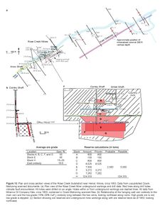
The Rose Creek Mines were operated by the Yingling Mining Company from 1942 to 1948 (Davis 1943, 1950) These mines were also called the Yingling Mines (Burmeister 1952) In 1942, Harve Smee sunk the Smee Shaft to 100 feet and drove drifts at the 50- and 100-foot levels (Burmeister 1952) The Conley Shaft was originally sunk to 90 feet (Burmeister 1952) but was later deepened to more than 300 feet. The vein lies along a fault trending N55°E and dipping 80°SE (Weller et al. 1952) Ozark-Mahoning mine maps indicated that the Conley Shaft was located in the middle of the mine workings. Working levels at 155, 215, 285, and 350 feet extended to the northeast and southwest along the fault away from the Conley Shaft. The Smee Shaft was at the northeast end of the mine and was also worked at the 50-foot level. The Minerva Oil Company commenced underground drilling in 1952, and the company reported low-grade ore below the 350-foot level between the main fault and the hanging wall fault. Most all of the exploration borings were drilled in a northwesterly or southeasterly direction to intersect a northeasterly striking fault or vein. Ozark-Mahoning maps suggest that a parallel fault, hosting 40% to 60% CaF2 ore, was present to the southeast and that between the two faults, lower grade mineralization attaining 15% to 20% CaF2 was present (Figure 10). Production at this mine from 1942 to 1949 was 8,500 tons of 60% CaF2 ore and 3,450 tons of 35% to 50% CaF2 ore (Burmeister 1952) In 1951, the Yingling Mining Company sold the Rose Creek property to the Minerva Oil Company (Holtzinger and Arundale 1955) Ozark-Mahoning mine maps indicate that additional ore was present along the master fault and in an east orebody. Minerva Oil Company reserve calculations from 1953 detailed that an additional 324,000 tons was possible along the master fault and that 97,000 tons was possible along the east orebody. Although the east orebody was 160 feet thick, with the top at 230 feet below the surface, the ore was low grade in sandstone and averaged about 19.6% CaF2. A hanging wall orebody was also present southeast of the Conley Mine workings. More information is needed to determine whether the low-grade ore was ever mined.
Mine Data/Information
- Other Data Files
File Type: Figure
Caption: Figure 10 Plan and cross section views of the Rose Creek Subdistrict near Herod, Illinois, circa 1953. Data from unpublished Ozark-
Mahoning scanned documents.
(a) Plan view of the Rose Creek Mine underground workings and drill data. Red lines along drill holes indicate fault encountered. All holes were drilled on an angle. Holes within or from underground workings are dashed lines. All data from Minerva Oil Company files, circa 1953, contained in Ozark-Mahoning scanned files.
(b) Relationship of the hanging wall vein orebody to the main vein and the low-grade (15%–20% CaF2) orebody lying between the two veins, looking northeast along veins. High-grade ore is red; low-grade is stippled.
(c) Section showing ore reserves and underground mine workings along with ore reserve block as of 1953, looking northwest.
Credit: Copyright © University of Illinois Board of Trustees
Publication: Circular 604
Mine Data
Host and associated rocks
| Host or associated |
Associated
|
| Rock type |
Plutonic Rock
|
| Rock unit name |
Mafic Dikes And Breccia Bodies
|
| Rock description |
Mafic Dikes And Breccia Bodies
|
| Stratigraphic age (youngest) |
Early Permian
|
| Stratigraphic age (youngest) |
Early Permian
|
| Stratigraphic age (youngest) |
Mississippian
|
| Stratigraphic age (youngest) |
Mississippian
|
| Host or associated |
Host
|
| Rock type |
Sedimentary Rock > Carbonate > Limestone
|
| Rock unit name |
Limestone
|
| Rock description |
Limestone
|
Ore Body Information
| General form |
LINEAR
|
| Strike |
N 55 DEG E
|
| Dip |
80 DEG SE
|
References
- Burmeister, H.L., 1952, Knox and Yingling fluorite mines, Hardin County, Illinois: U.S. Bureau of Mines, Report of Investigations 4856, 8 p.
|
- Davis, H.W., 1943, Fluorspar and cryolite, in F.M. Shore, ed., Minerals yearbook 1941: U.S. Department of the Interior, Bureau of Mines, Economics and Statistics Service, p. 1399–1416.
|
- Davis, H.W., 1950, Fluorspar and cryolite, in E.W. Pehrson and A.F. Matthews, eds., Minerals yearbook 1948: U.S. Department of the Interior, Bureau of Mines, Economics and Statistics Division, p. 525–544.
|
- Holtzinger, J.E., and J.C. Arundale, 1955, Fluorspar and cryolite, in J.J. Forbes, ed., Minerals yearbook 1952: Metals and minerals (except fuels), Volume I: U.S. Department of the Interior, Bureau of Mines, Minerals Division, p. 418–431.
|
- Weller, J.M., R.M. Grogan, and F.E. Tippie, 1952, Geology of the fluorspar deposits of Illinois: Illinois State Geological Survey, Bulletin 76, 147 p.
|
- BAXTER, J. W., DESBOROUGH, G. A. AND SHAW, C. W., 1967, AREAL GEOLOGY OF THE ILLINOIS FLUORSPAR DISTRICT, PART 3: ILL. STATE GEOL. SURV. CIRC. 413, 41 P. (Reference from the USGS MRDS System)
|
- 1942 GEOLMAP ILL. STATE GEOLOGICAL SURVEY, J. M. WELLER (Reference from the USGS MRDS System)
|
- 1961 GEOLMAP ILL. STATE GEOLOGICAL SURVEY, G. A. DESBOROUGH (Reference from the USGS MRDS System)
|
- MC GINNIS, L. D. AND BRADBURY, J. C., 1964, AEROMAGNETIC STUDY OF THE HARDIN COUNTY AREA, ILLINOIS: ILL. STATE GEOLOGICAL SURVEY CIRC. 363, 12 P. (Reference from the USGS MRDS System)
|
External Links
Mineral Resources Data System (MRDS) USGS Link
https://mrdata.usgs.gov/mrds/show-mrds.php?dep_id=10069406https://mrdata.usgs.gov/mrds/show-mrds.php?dep id=10069406