Mine Index 10069407 Ozark-Mahoning Company/Minerva Oil Company, Hill-Ledford,Deardorf,Oxford,Green,Davis Group,Minerva No. 1,Victory,Crystal Mines,Fluorspar Products Lead Hill Group,Grischy Mines,Austin Mines,Tems Prospect,Oxford Morrison Open Pit,Frayser Mines,Patton Shaft,Martin Prospect,Eureka Prospect,Hill Property,Winn Property,Underwood Property,Frailey Workings,Patrick Mine,Palmer Mine,Tower Rock Workings
| Disclaimer | ||
|---|---|---|
| S-T-R | 23,24,25,26,34,34-11S-9E | |
| County: | Hardin | |
| Quadrangle: | Saline Mines | |
| District: | Fluorspar District | |
| Subdistrict: | Cave-in-Rock Subdistrict | |
Mine Index Number: 10069407
| ISGS ID: | MSHA ID: | ||
|---|---|---|---|
| MAS ID: | MRDS ID: | W006924 | |
| Company Name: | Minerva Oil Company, Ozark-Mahoning Company | ||
| Mine/Site Name: | Victory, Green, Patrick Mine, Hill-Ledford, Deardorf, Oxford, Davis Group, Minerva No. 1, Crystal Mines, Fluorspar Products Lead Hill Group, Grischy Mines, Austin Mines, Tems Prospect, Oxford Morrison Open Pit, Frayser Mines, Patton Shaft, Martin Prospect, Eureka Prospect, Hill Property, Winn Property, Underwood Property, Frailey Workings, Palmer Mine, Tower Rock Workings | ||
| Active/Abandoned: | Abandoned | ||
| Start Date: | circa 1919 | End Date: | Unknown |
| Commodity Type: | Metallic, Non-Metallic | ||
| Commodity: | Barite(Barytes), Cadmium, Calcite, Fluorspar, Gallium, Germanium, Lead, Silver, Quartz, Zinc | ||
| Minerals Present: | Barite, Calcite, Fluorite, Quartz, Sphalerite, Smithsonite, Pyrite, Chalcopyrite, Strontianite, Anglesite | ||
| Type of Mine: | Unknown | ||
| District: | Fluorspar District | Subdistrict: | Cave-in-Rock Subdistrict |
| County: | Hardin | ||
| Section/Township/Range: | 23,24,25,26,34,34-11S-9E | ||
| Latitude,Longitude: | 37.5167399999998,-88.2000299999998 | ||
| Unit(s) Mined: | |||
| Feature(s) Mined: | |||
| MRDS Link: | https://mrdata.usgs.gov/mrds/show-mrds.php?dep id=10069407 | ||
| Mindat link: | |||
Discussion
Appears that this is a single entry for all mines on the quadrangle. Will need to be divided up.
Ownership information
| Type | Owner-Operator |
| Owner | Minerva Oil Co. (Minerva No. 1, Crystal, Victory) |
| Type | Owner-Operator |
| Owner | Ozark - Mahoning Co. (Hill - Ledford, Oxford, Green And Davis Group, Deardorf). |
Mine Data/Information
 These files may not be true to scale and are not georgistered. These files may not be true to scale and are not georgistered.
|
Mine Index: | 10069407 |
|---|---|---|
| Company: | ||
| Mine Name: | ||
| More Info: | AustinBishopPlanDrill.jpg | |
| Click to download Full ResolutionThese files are true to scale and most are georegistered for gis software. File Type: Map | ||
 These files may not be true to scale and are not georgistered. These files may not be true to scale and are not georgistered.
|
Mine Index: | 10069407 |
|---|---|---|
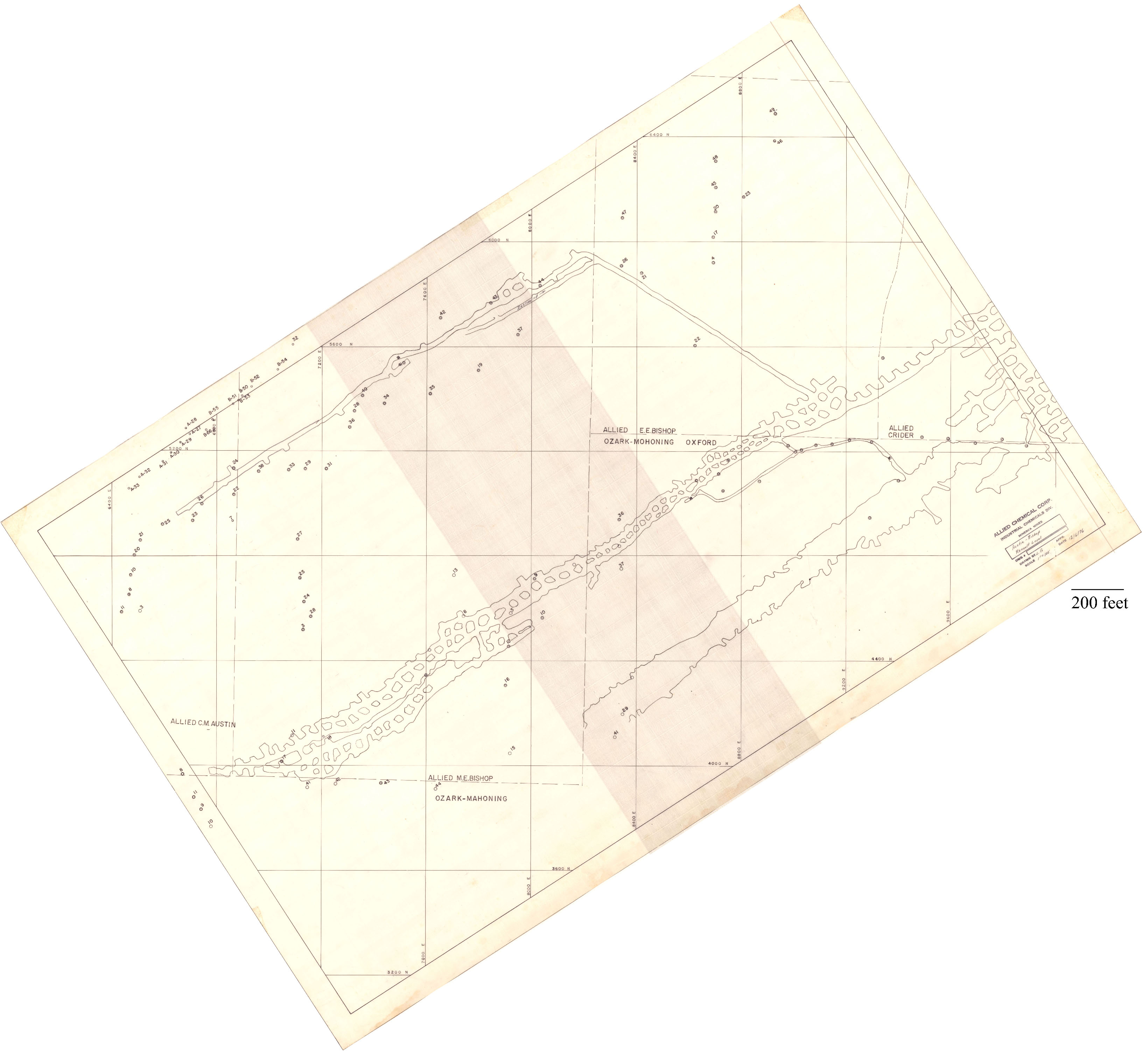
| Company: | Allied Chemical Corporation | |
| Mine Name: | ||
| More Info: | AustinBishopRenaultLevelPlanDrill.jpg | |
| Click to download Full ResolutionThese files are true to scale and most are georegistered for gis software. File Type: Map Caption: Allied Chemical Corporation Industrial Chemicals Division
Minerva Mines
Austin-Bishop Renault Level | ||
 These files may not be true to scale and are not georgistered. These files may not be true to scale and are not georgistered.
|
Mine Index: | 10069407 |
|---|---|---|
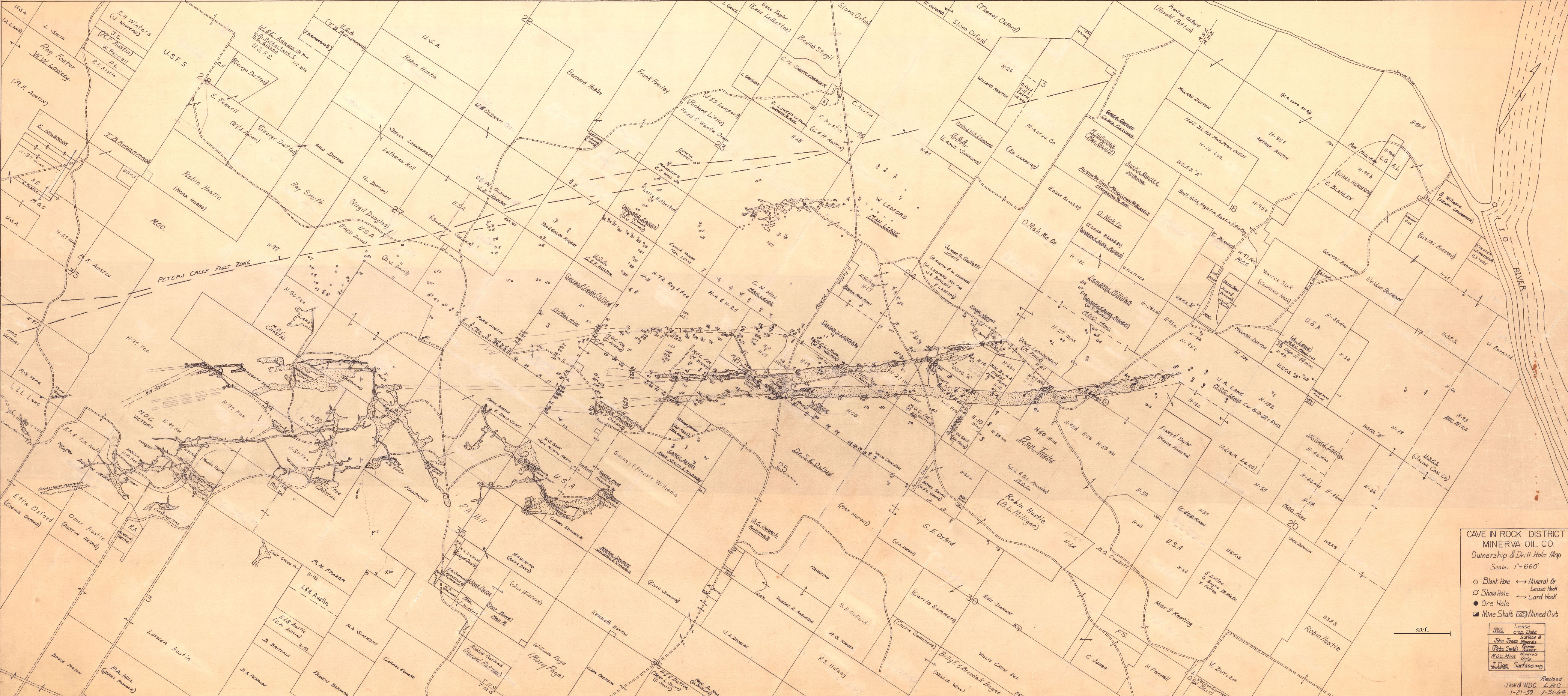
| Company: | Minerva Oil Company | |
| Mine Name: | ||
| More Info: | CaveInRock MIN PropertyDrillHole.jpg | |
| Click to download Full ResolutionThese files are true to scale and most are georegistered for gis software. File Type: Map Caption: Cave In Rock District Minerva Oil Company | ||
 These files may not be true to scale and are not georgistered. These files may not be true to scale and are not georgistered.
|
Mine Index: | 10069407 |
|---|---|---|
| Company: | ||
| Mine Name: | ||
| More Info: | CaveInRockHillLedfordMinervaPlanDrill.jpg | |
| Click to download Full ResolutionThese files are true to scale and most are georegistered for gis software. File Type: Map Caption: Ozark-Mahoning Company Map of Hill-Ledford Tract and Surrounding Acreages | ||
 These files may not be true to scale and are not georgistered. These files may not be true to scale and are not georgistered.
|
Mine Index: | 10069407 |
|---|---|---|
| Company: | Mahoning Mining Company | |
| Mine Name: | ||
| More Info: | CaveInRockPlanDrillOriginal.jpg | |
| Click to download Full ResolutionThese files are true to scale and most are georegistered for gis software. File Type: Map Caption: Mahoning Ming Company Map of Cave-in-Rock Fluorspar District | ||
 These files may not be true to scale and are not georgistered. These files may not be true to scale and are not georgistered.
|
Mine Index: | 10069407 |
|---|---|---|
| Company: | Ozark-Mahoning Company | |
| Mine Name: | ||
| More Info: | CrystalMine UndergroundWorking Plan 2.jpg | |
| Click to download Full ResolutionThese files are true to scale and most are georegistered for gis software. File Type: Map Caption: Ozark-Mahoning Company Map of Crystal Fluorspar Company Property Cave In Rock District | ||
 These files may not be true to scale and are not georgistered. These files may not be true to scale and are not georgistered.
|
Mine Index: | 10069407 |
|---|---|---|
| Company: | ||
| Mine Name: | ||
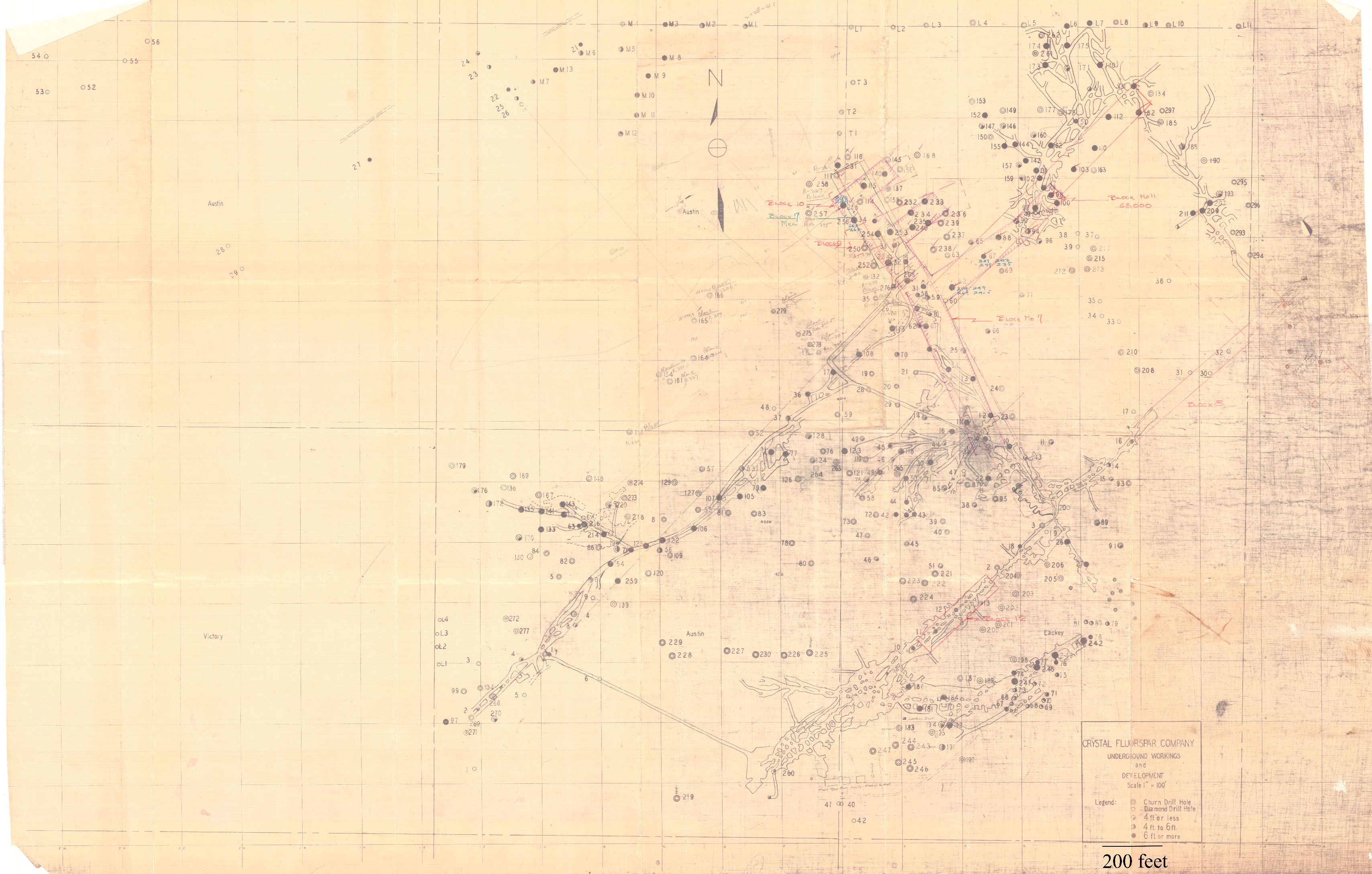
| More Info: | CrystalMine UndergroundWorking Plan notes.jpg | |
| Click to download Full ResolutionThese files are true to scale and most are georegistered for gis software. File Type: Map Caption: Crystal Fluorspar Company Underground workings and development | ||
 These files may not be true to scale and are not georgistered. These files may not be true to scale and are not georgistered.
|
Mine Index: | 10069407 |
|---|---|---|
| Company: | ||
| Mine Name: | ||
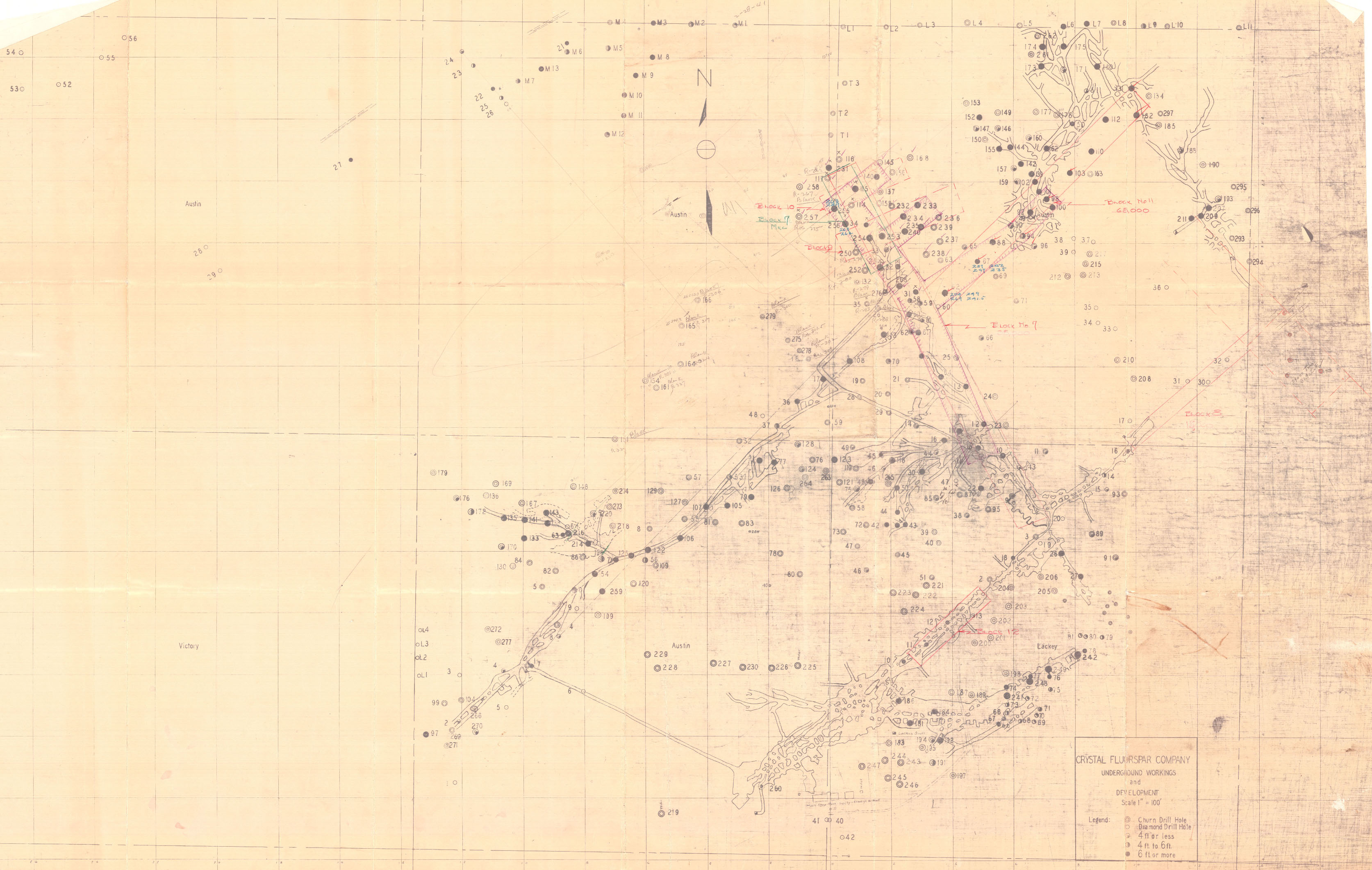
| More Info: | CrystalMine UndergroundWorking Plan.jpg | |
| Click to download Full ResolutionThese files are true to scale and most are georegistered for gis software. File Type: Map Caption: Crystal Fluorspar Company Underground workings and development | ||
 These files may not be true to scale and are not georgistered. These files may not be true to scale and are not georgistered.
|
Mine Index: | 10069407 |
|---|---|---|
| Company: | ||
| Mine Name: | ||
| More Info: | CrystalMineUG MIN CaveInRock Plan.jpg | |
| Click to download Full ResolutionThese files are true to scale and most are georegistered for gis software. File Type: Map Caption: Bottom of Rosiclare Formation Date: 1950 | ||
References
|
|
|
|
|
|
|
|
|
|
|
External Links
Mineral Resources Data System (MRDS) USGS Link
https://mrdata.usgs.gov/mrds/show-mrds.php?dep_id=10069407https://mrdata.usgs.gov/mrds/show-mrds.php?dep id=10069407