Mine Index 10082962 Cave In Rock Mine
| Disclaimer | ||
|---|---|---|
| S-T-R | 4(NWNE)-12S-9E | |
| County: | Hardin | |
| Quadrangle: | Saline Mines | |
| District: | Fluorspar District | |
| Subdistrict: | Cave-in-Rock Subdistrict | |
Mine Index Number: 10082962
| ISGS ID: | MSHA ID: | ||
|---|---|---|---|
| MAS ID: | 170690009 | MRDS ID: | W062434 |
| Company Name: | |||
| Mine/Site Name: | Cave In Rock Mine | ||
| Active/Abandoned: | Abandoned | ||
| Start Date: | Unknown | End Date: | Unknown |
| Commodity Type: | Non-Metallic | ||
| Commodity: | Fluorspar | ||
| Minerals Present: | Calcite, Fluorite | ||
| Type of Mine: | Surface, Underground | ||
| District: | Fluorspar District | Subdistrict: | Cave-in-Rock Subdistrict |
| County: | Hardin | ||
| Section/Township/Range: | 4(NWNE)-12S-9E | ||
| Latitude,Longitude: | 37.5086799999998,-88.21114 | ||
| Unit(s) Mined: | Upper Valmeyeran Series, Aux Vases Sandstone, Ste. Genevieve Limestone, St. Louis Sandstone | ||
| Feature(s) Mined: | |||
| MRDS Link: | https://mrdata.usgs.gov/mrds/show-mrds.php?dep id=10082962 | ||
| Mindat link: | |||
Discussion
Ore body information: BLANKET
THE REPLACEMENT DEPOSIT IS IN LIMESTONE BELOW A THIN SANDSTONE CAPPING A FEW INCHES TO THREE FEET THICK. A FEW SHALE BEDS ARE ASSOCIATED WITH THE SANDSTONE MAKING IT RELATIVELY IMPERVIOUS AND RESISTANT TO REPLACING SOLUTIONS. COARSE FLUORITE ORE AND FINER BANDED ORE OCCUR IN THE MINE.
THE DEPOSIT IS EXPLOITED BY IRREGULAR DRIFTAND FLAT-LYING STOPES
BEDDED FLUORITE DEPOSITS PRIMARILY FORM BY SELECTIVE REPLACEMENT OF LIMESTONE BEDS. WATER FOR THE ACCOMPANYING MILL WAS PUMPED FROM A SINK-HOLE LAKE ONE MILE TO THE SOUTH.
Mine Data/Information
 These files may not be true to scale and are not georgistered. These files may not be true to scale and are not georgistered.
|
Mine Index: | 10082962 |
|---|---|---|
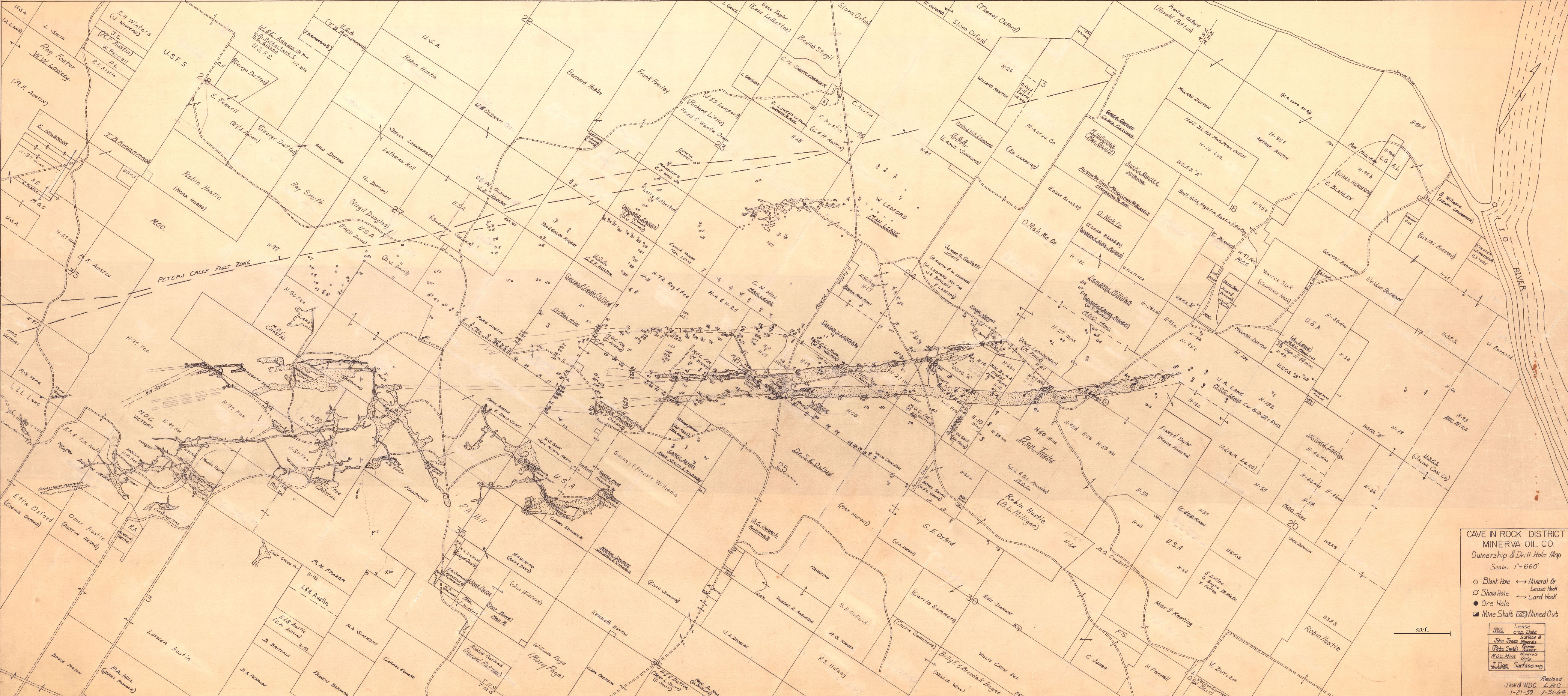
| Company: | Minerva Oil Company | |
| Mine Name: | ||
| More Info: | CaveInRock MIN PropertyDrillHole.jpg | |
| Click to download Full ResolutionThese files are true to scale and most are georegistered for gis software. File Type: Map Caption: Cave In Rock District Minerva Oil Company | ||
 These files may not be true to scale and are not georgistered. These files may not be true to scale and are not georgistered.
|
Mine Index: | 10082962 |
|---|---|---|
| Company: | Ozark-Mahoning Company | |
| Mine Name: | ||
| More Info: | CaveInRockFluorsparDistrict1956 OZM.jpg | |
| Click to download Full ResolutionThese files are true to scale and most are georegistered for gis software. File Type: Map Caption: Ozark-Mahoning Company Map of Cavie-In-Rock Fluorspar District | ||
 These files may not be true to scale and are not georgistered. These files may not be true to scale and are not georgistered.
|
Mine Index: | 10082962 |
|---|---|---|
| Company: | Ozark-Mahoning Company | |
| Mine Name: | ||
| More Info: | CaveInRockPlanDrill.jpg | |
| Click to download Full ResolutionThese files are true to scale and most are georegistered for gis software. File Type: Map Caption: Ozark-Mahoning Company Map of Cave-in-Rock Fluorspar District | ||
 These files may not be true to scale and are not georgistered. These files may not be true to scale and are not georgistered.
|
Mine Index: | 10082962 |
|---|---|---|
| Company: | Mahoning Mining Company | |
| Mine Name: | ||
| More Info: | CaveInRockPlanDrillOriginal.jpg | |
| Click to download Full ResolutionThese files are true to scale and most are georegistered for gis software. File Type: Map Caption: Mahoning Ming Company Map of Cave-in-Rock Fluorspar District | ||
References
|
|
|
|
|
|
|
External Links
Mineral Resources Data System (MRDS) USGS Link
https://mrdata.usgs.gov/mrds/show-mrds.php?dep id=10082962
Also referenced as 10144982