Mine Index 10082967 Minerva Oil Company, Crystal Mine
| Disclaimer | ||
|---|---|---|
| S-T-R | 34(E2)-11S-9E | |
| County: | Hardin | |
| Quadrangle: | Saline Mines | |
| District: | Fluorspar District | |
| Subdistrict: | Cave-in-Rock Subdistrict | |
Mine Index Number: 10082967
| ISGS ID: | MSHA ID: | ||
|---|---|---|---|
| MAS ID: | 170690036 | MRDS ID: | W062441 |
| Company Name: | Minerva Oil Company | ||
| Mine/Site Name: | Crystal Mine | ||
| Active/Abandoned: | Abandoned | ||
| Start Date: | circa 1975 | End Date: | Unknown |
| Commodity Type: | Metallic, Non-Metallic | ||
| Commodity: | Fluorspar, Lead, Silver, Zinc | ||
| Minerals Present: | Galena, Calcite, Fluorite, Sphalerite | ||
| Type of Mine: | Underground | ||
| District: | Fluorspar District | Subdistrict: | Cave-in-Rock Subdistrict |
| County: | Hardin | ||
| Section/Township/Range: | 34(E2)-11S-9E | ||
| Latitude,Longitude: | 37.5153499999998,-88.19253 | ||
| Unit(s) Mined: | Upper Valmeyeran Series, Aux Vases Sandstone, Ste. Genevieve Limestone, St. Louis Sandstone | ||
| Feature(s) Mined: | |||
| MRDS Link: | https://mrdata.usgs.gov/mrds/show-mrds.php?dep id=10082967 | ||
| Mindat link: | |||
Discussion
Geologic structure: A Sharp Northwest-Trending Fold In The Northeast Part Of The Mine.
Ore body information: BLANKET
Discovered: 1842, 1929
| Ore body information | |
|---|---|
| Strike | N50E |
| Dip | 08N |
| Thickness | 3M |
| Depth to top | 50M |
| Width | 36M |
| Length | 800M |
| Area | 4HA |
| Field | Value |
| Type of Orebody #1 | REPLACEMENT |
| Shape of Orebody #1 | TABULAR |
| Type of Orebody #2 | BRECCIA FILL |
| Type of Orebody #3 | DISSEMINATED |
| Primary mode of Origin | HYDROTHERMAL |
| Secondary mode of Origin | CONT METASOMATIC |
| Primary Ore Control | FAULTING |
| Secondary Ore Control | BEDDING |
| Degree of Wallrock Alter. | SLIGHT |
| Type of Wallrock Alter. #1 | DOLOMITIZATION |
| Strike And Dip | N50E |
| Total Surface Area (HA) | 4 |
| Date of Last Modification | 830126 |
| Workings at the site | |
|---|---|
| Type of workings | Underground |
| Field | Value |
| MAS Development Schedule # | 1 |
| Mining Record # | 1 |
| Status of Mining Method | ESTIMATE |
| Mining Method | ROOM AND PILLAR 10-34 |
| Swell Factor | .6 |
| Percent Waste Rock | 25 |
| Hardness of Rock | SOFT NONPLASTIC FISSURED MODERATE WATER |
| Rock Characteristics | ONE SYSTEM OF WEAKNESS PLANES |
| Rock Support Chars. | SUPPORTING MAY BACK SLAB |
| Mine Support Chars. | POST, HEADBOARD, CAPS, ROOF BOLTS |
| Capacity Units | MT ORE/DAY |
| Units of Production | $/MT ORE |
| Year of Information | 1972 |
RECORD 151/ 99 PERCENT OF FLUORSPAR PROCESSED BY GRAVITY MET WITH 95 PERCENT RECOVERY 95 PERCENT PROCESSED BY FLOATATION 92 PERCENT RECOVERY 27.6 PERCENT MILLFEED SHIPPED AS CONCENT RECORD 160/ MATERIAL HAULED BY TRUCK TO OHIO RIVER THIS MINE WAS OWNED BY MINERVA OIL CO.. MINERVA WAS BOUGHT OUT BY ALLIED. IN A TELEPHONE CONVERSATION WITH DAVID E. MORSE, FLOURINE SPECIALIST WITH USBM, HE STATED THAT THIS MINE WAS CLOSED IN 1972 AFTER PILLAR EXTRACTION.
Mine Data/Information
 These files may not be true to scale and are not georgistered. These files may not be true to scale and are not georgistered.
|
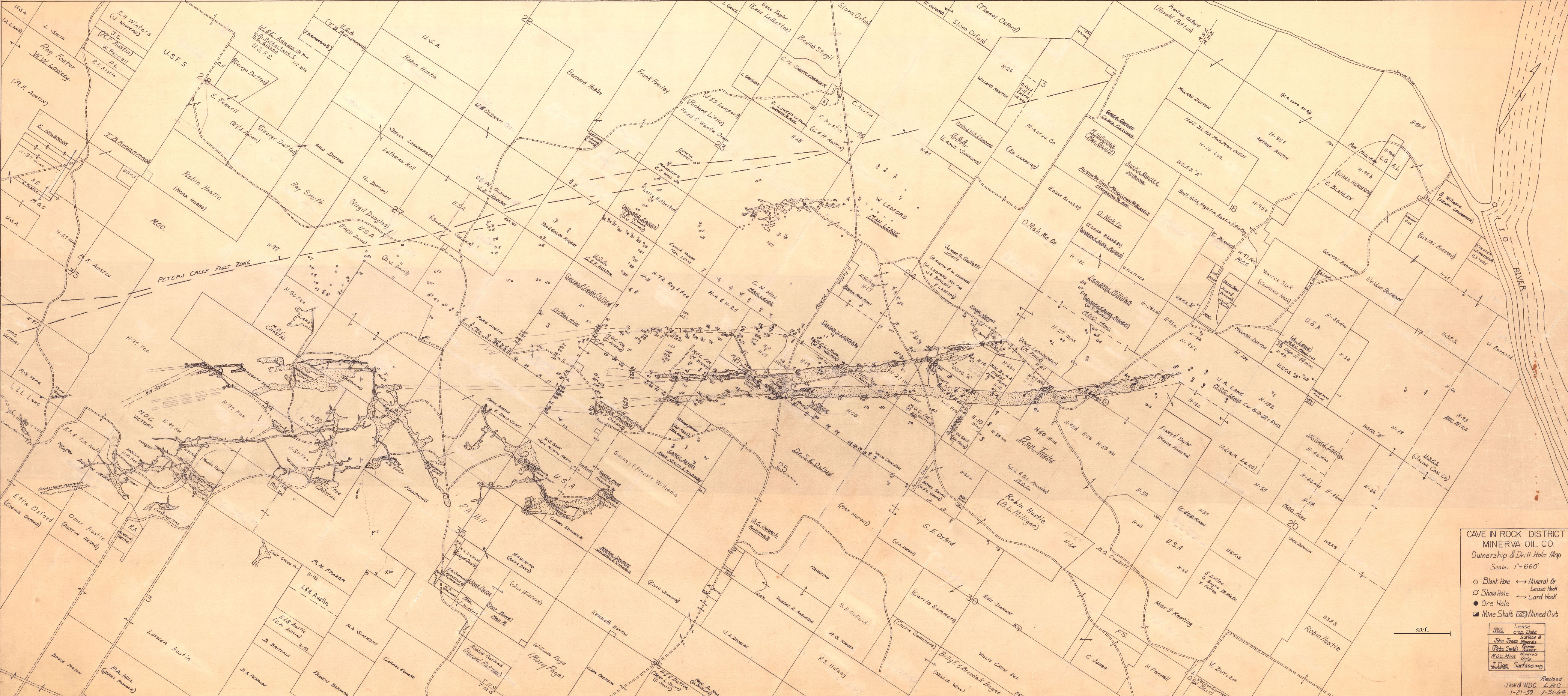
Mine Index: | 10082967 |
|---|---|---|
| Company: | Minerva Oil Company | |
| Mine Name: | ||
| More Info: | CaveInRock MIN PropertyDrillHole.jpg | |
| Click to download Full ResolutionThese files are true to scale and most are georegistered for gis software. File Type: Map Caption: Cave In Rock District Minerva Oil Company | ||
 These files may not be true to scale and are not georgistered. These files may not be true to scale and are not georgistered.
|
Mine Index: | 10082967 |
|---|---|---|
| Company: | Mahoning Mining Company | |
| Mine Name: | ||
| More Info: | CaveInRockPlanDrillOriginal.jpg | |
| Click to download Full ResolutionThese files are true to scale and most are georegistered for gis software. File Type: Map Caption: Mahoning Ming Company Map of Cave-in-Rock Fluorspar District | ||
 These files may not be true to scale and are not georgistered. These files may not be true to scale and are not georgistered.
|
Mine Index: | 10082967 |
|---|---|---|
| Company: | Ozark-Mahoning Company | |
| Mine Name: | ||
| More Info: | CrystalMine UndergroundWorking Plan 2.jpg | |
| Click to download Full ResolutionThese files are true to scale and most are georegistered for gis software. File Type: Map Caption: Ozark-Mahoning Company Map of Crystal Fluorspar Company Property Cave In Rock District | ||
 These files may not be true to scale and are not georgistered. These files may not be true to scale and are not georgistered.
|
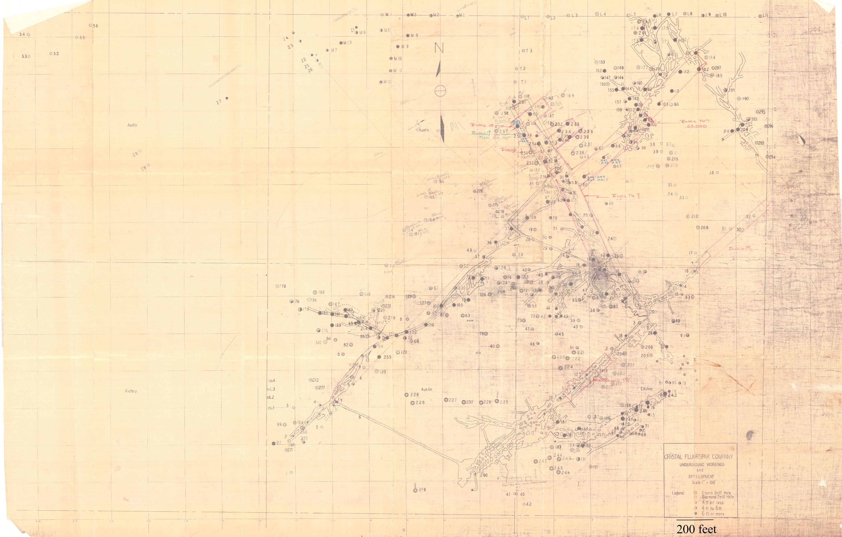
Mine Index: | 10082967 |
|---|---|---|
| Company: | ||
| Mine Name: | ||
| More Info: | CrystalMine UndergroundWorking Plan notes.jpg | |
| Click to download Full ResolutionThese files are true to scale and most are georegistered for gis software. File Type: Map Caption: Crystal Fluorspar Company Underground workings and development | ||
 These files may not be true to scale and are not georgistered. These files may not be true to scale and are not georgistered.
|
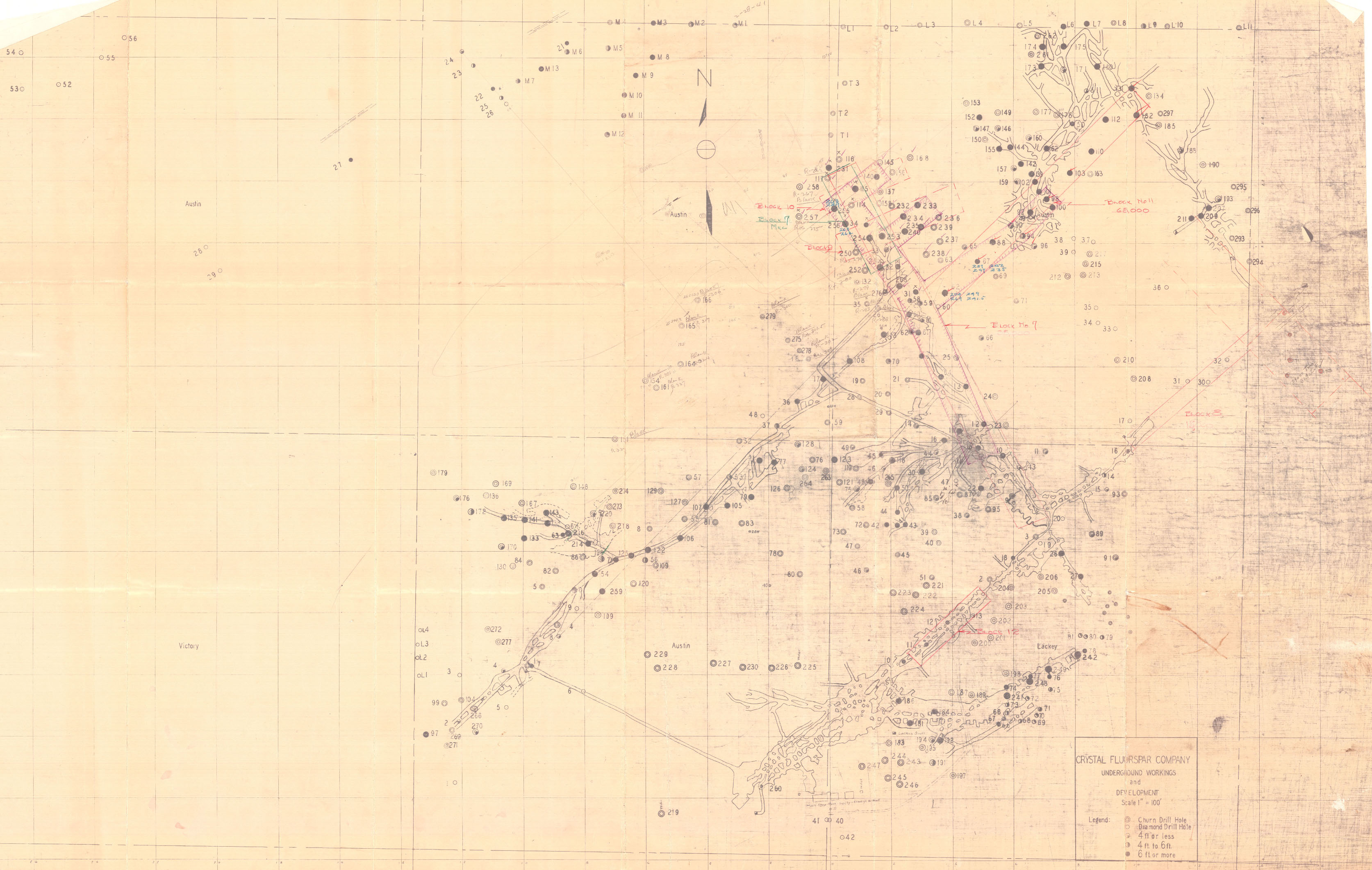
Mine Index: | 10082967 |
|---|---|---|
| Company: | ||
| Mine Name: | ||
| More Info: | CrystalMine UndergroundWorking Plan.jpg | |
| Click to download Full ResolutionThese files are true to scale and most are georegistered for gis software. File Type: Map Caption: Crystal Fluorspar Company Underground workings and development | ||
 These files may not be true to scale and are not georgistered. These files may not be true to scale and are not georgistered.
|
Mine Index: | 10082967 |
|---|---|---|
| Company: | ||
| Mine Name: | ||
| More Info: | CrystalMineUG MIN CaveInRock Plan.jpg | |
| Click to download Full ResolutionThese files are true to scale and most are georegistered for gis software. File Type: Map Caption: Bottom of Rosiclare Formation Date: 1950 | ||
 These files may not be true to scale and are not georgistered. These files may not be true to scale and are not georgistered.
|
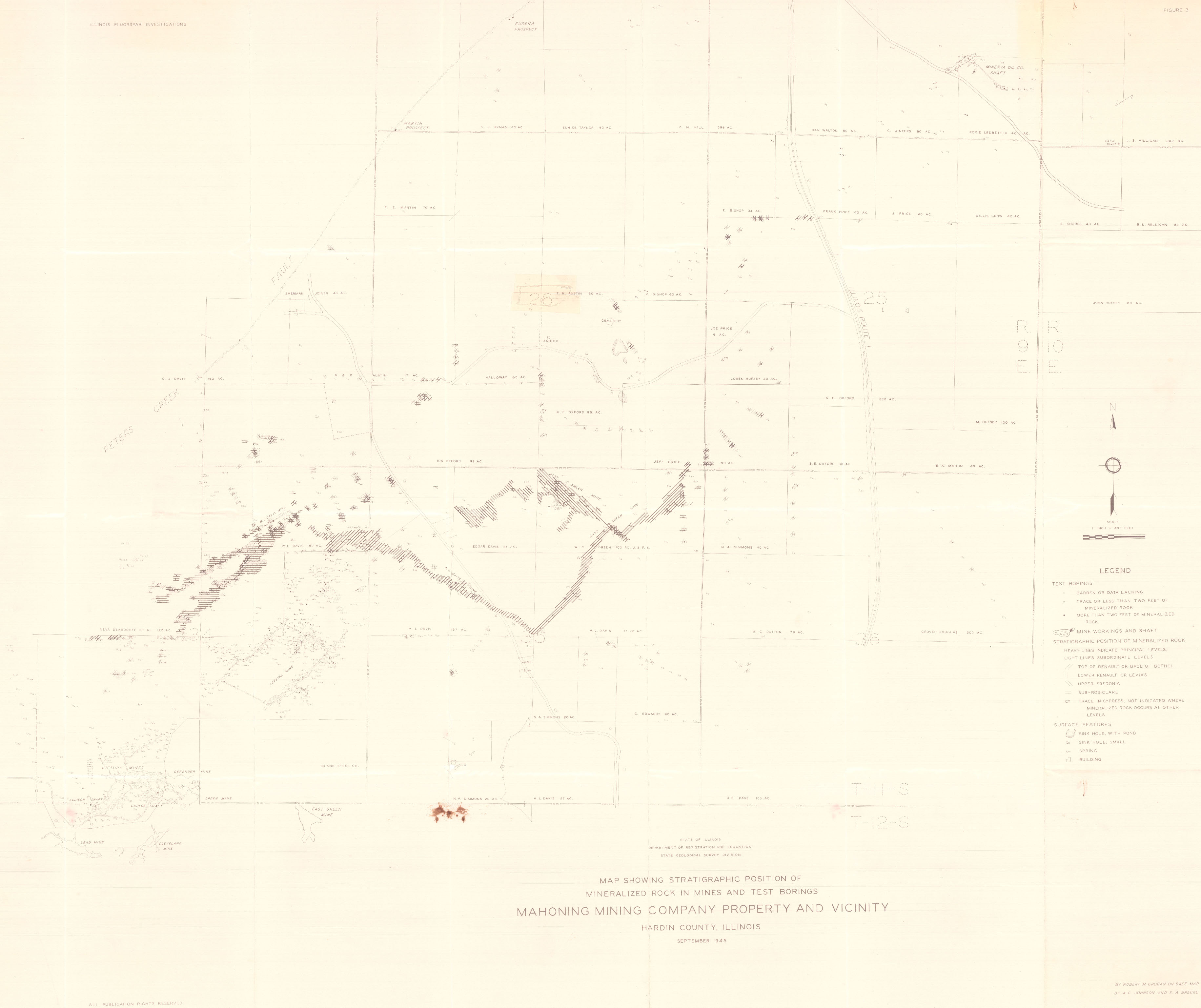
Mine Index: | 10082967 |
|---|---|---|
| Company: | ||
| Mine Name: | ||
| More Info: | HardinCounty OZM GeoDrillMap.jpg | |
| Click to download Full ResolutionThese files are true to scale and most are georegistered for gis software. File Type: Map Caption: Map showing Stratigraphic Position of Mineralized rocks in Mines and test borings. Mahoning Mining Company Property and vicinity. (ISGS Map) | ||
References
|
|
|
|
|
|
|
|
|
External Links
Mineral Resources Data System (MRDS) USGS Link
https://mrdata.usgs.gov/mrds/show-mrds.php?dep id=10082967
Also referenced as 10120834