Mine Index 10082976 Ozark-Mahoning Company, East Green Mine
| Disclaimer | ||
|---|---|---|
| S-T-R | 35(NE4)-11S-9E | |
| County: | Hardin | |
| Quadrangle: | Saline Mines | |
| District: | Fluorspar District | |
| Subdistrict: | ||
Mine Index Number: 10082976
| ISGS ID: | MSHA ID: | ||
|---|---|---|---|
| MAS ID: | 170690143 | MRDS ID: | W062453 |
| Company Name: | Ozark-Mahoning Company | ||
| Mine/Site Name: | East Green Mine | ||
| Active/Abandoned: | Abandoned | ||
| Start Date: | Unknown | End Date: | Unknown |
| Commodity Type: | Metallic, Non-Metallic | ||
| Commodity: | Fluorspar, Lead, Silver, Zinc | ||
| Minerals Present: | Barite | ||
| Type of Mine: | Underground | ||
| District: | Fluorspar District | Subdistrict: | |
| County: | Hardin | ||
| Section/Township/Range: | 35(NE4)-11S-9E | ||
| Latitude,Longitude: | 37.5309,-88.1766999999998 | ||
| Unit(s) Mined: | Chesterian Series, Glen Dean Limestone, Cypress Sandstone, Renault Limestone | ||
| Feature(s) Mined: | |||
| MRDS Link: | https://mrdata.usgs.gov/mrds/show-mrds.php?dep id=10082976 | ||
| Mindat link: | |||
Discussion
ABOUT 0.2 MI ESE OF WEST GREEN MINE
THIS MINE PRODUCED BARITE-FLUORITE CONCENTRATES WHICH WERE SOLD UNDER THE NAME FLUORBARITE FOR USE IN GLASS MANUFACTURING.
| Geologic structures | |
|---|---|
| Type of structure | Local |
| Structure description | Syncline Down The Center Of The Main Mineralized Area. |
Ore body: BLANKET
Controls for ore emplacement: Selective Replacement Of Limestone Beds.
MINED UNDERGROUND VIA A SHAFT.
BEDDED FLUORITE DEPOSITS FORM PRIMARILY FROM SELECTIVE REPLACEMENT OF LIMESTONE BEDS.
Mine Data/Information
 These files may not be true to scale and are not georgistered. These files may not be true to scale and are not georgistered.
|
Mine Index: | 10082976 |
|---|---|---|
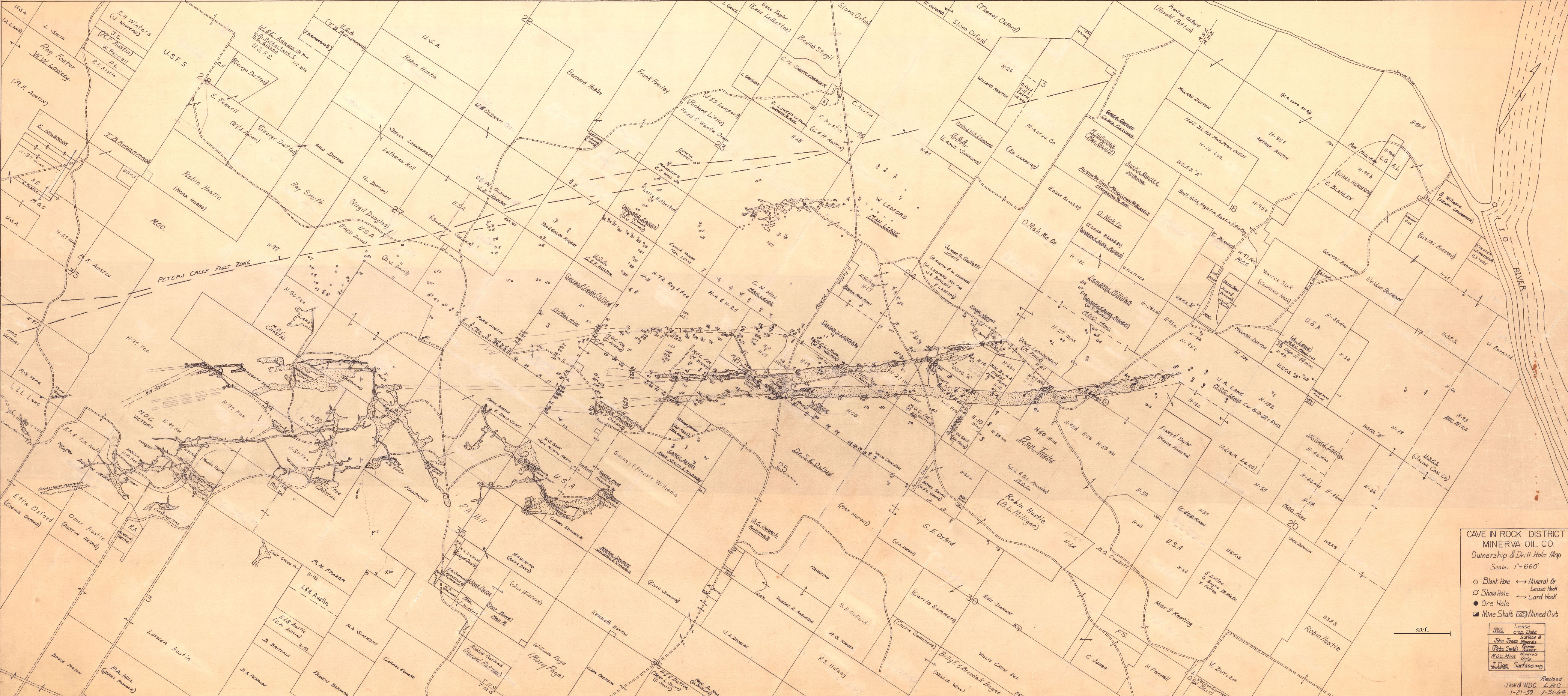
| Company: | Minerva Oil Company | |
| Mine Name: | ||
| More Info: | CaveInRock MIN PropertyDrillHole.jpg | |
| Click to download Full ResolutionThese files are true to scale and most are georegistered for gis software. File Type: Map Caption: Cave In Rock District Minerva Oil Company | ||
 These files may not be true to scale and are not georgistered. These files may not be true to scale and are not georgistered.
|
Mine Index: | 10082976 |
|---|---|---|
| Company: | ||
| Mine Name: | ||
| More Info: | CaveInRockFluorsparDistrict OZM.jpg | |
| Click to download Full ResolutionThese files are true to scale and most are georegistered for gis software. File Type: Map Caption: Ozark-Mahoning Company Map of Cave-In-Rock district | ||
 These files may not be true to scale and are not georgistered. These files may not be true to scale and are not georgistered.
|
Mine Index: | 10082976 |
|---|---|---|
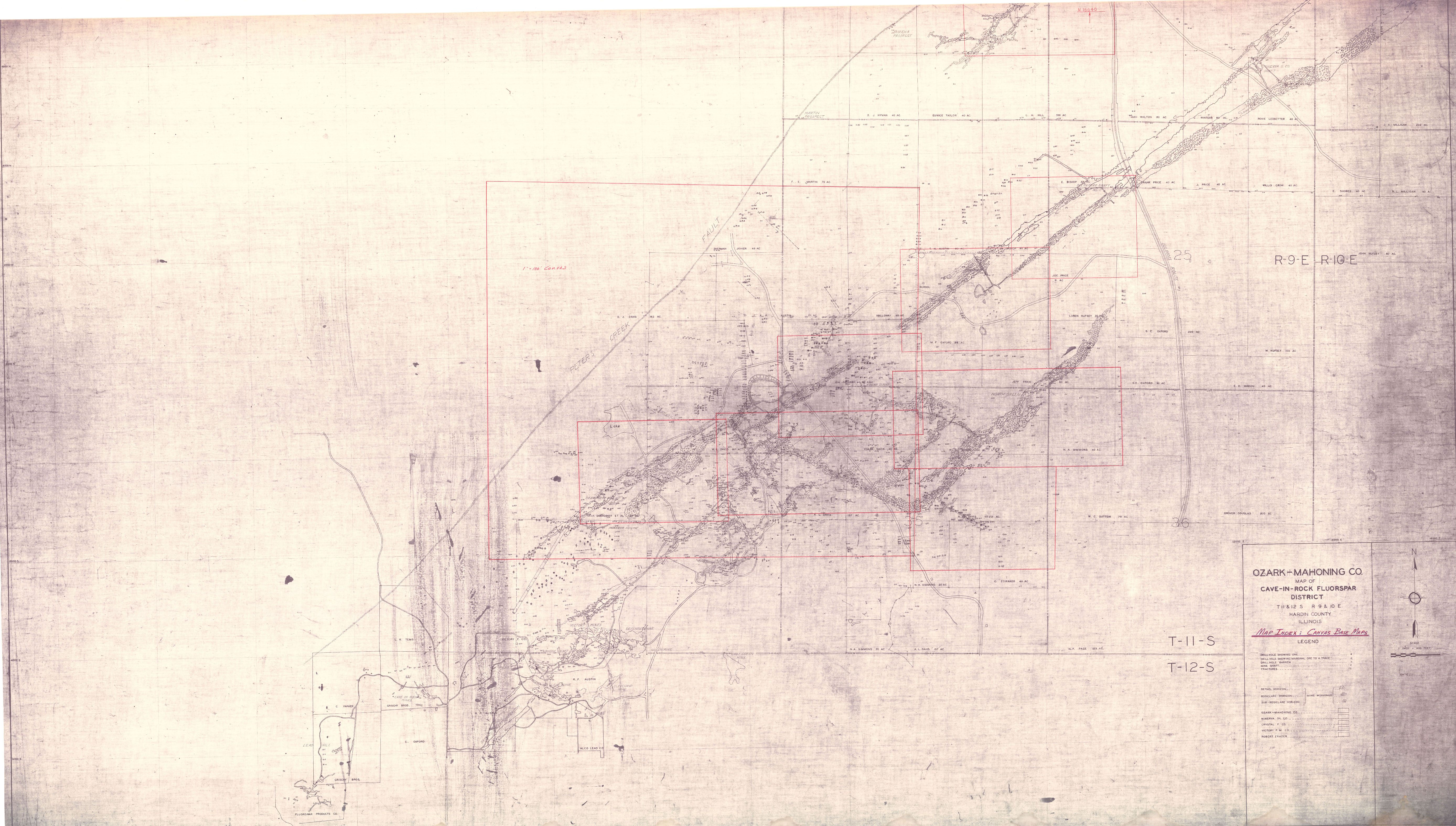
| Company: | Ozark-Mahoning Company | |
| Mine Name: | ||
| More Info: | CaveInRockFluorsparDistrict1956 OZM.jpg | |
| Click to download Full ResolutionThese files are true to scale and most are georegistered for gis software. File Type: Map Caption: Ozark-Mahoning Company Map of Cavie-In-Rock Fluorspar District | ||
 These files may not be true to scale and are not georgistered. These files may not be true to scale and are not georgistered.
|
Mine Index: | 10082976 |
|---|---|---|
| Company: | ||
| Mine Name: | ||
| More Info: | CaveInRockHillLedfordMinervaPlanDrill.jpg | |
| Click to download Full ResolutionThese files are true to scale and most are georegistered for gis software. File Type: Map Caption: Ozark-Mahoning Company Map of Hill-Ledford Tract and Surrounding Acreages | ||
 These files may not be true to scale and are not georgistered. These files may not be true to scale and are not georgistered.
|
Mine Index: | 10082976 |
|---|---|---|
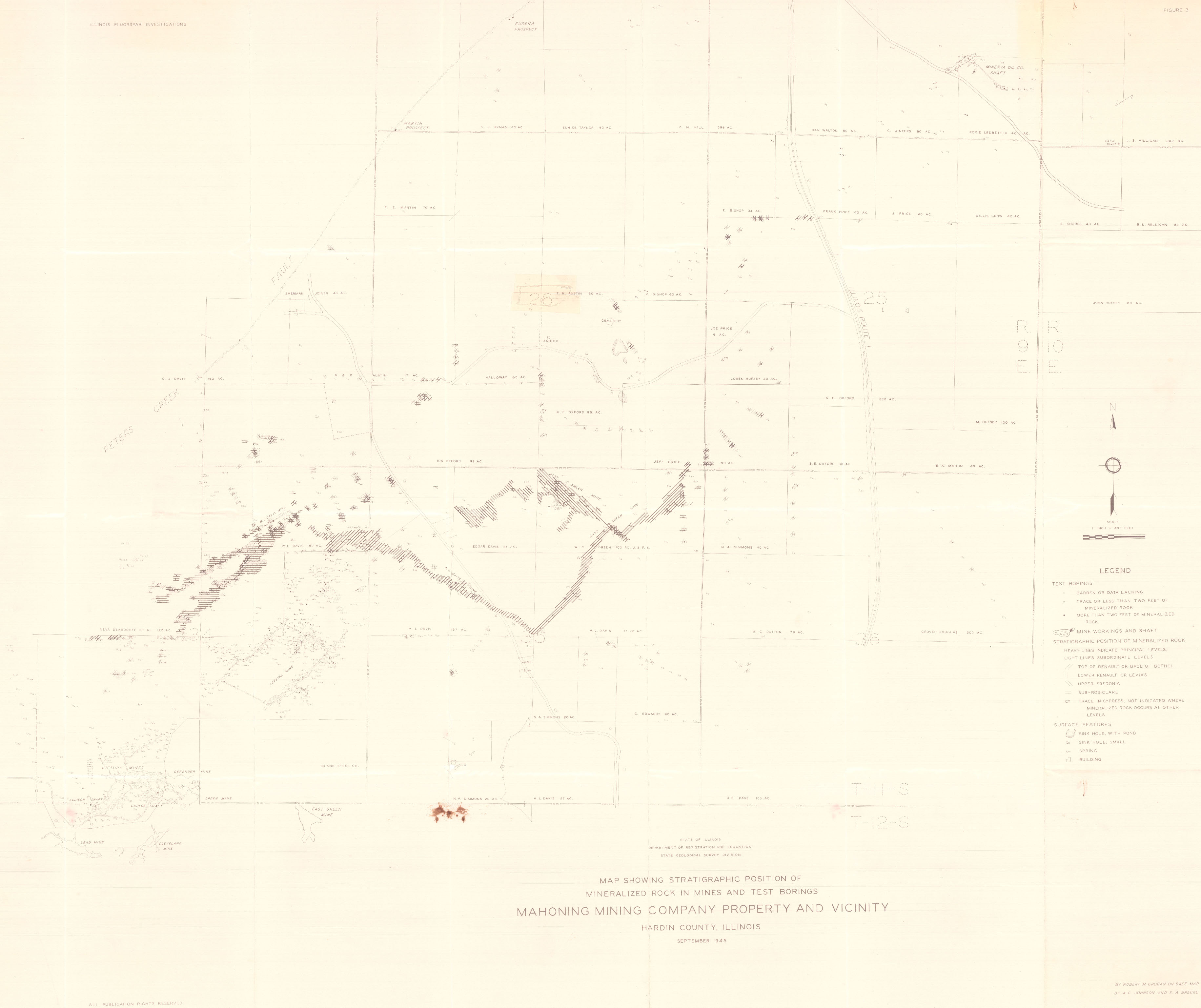
| Company: | Mahoning Mining Company | |
| Mine Name: | ||
| More Info: | CaveInRockPlanDrillOriginal.jpg | |
| Click to download Full ResolutionThese files are true to scale and most are georegistered for gis software. File Type: Map Caption: Mahoning Ming Company Map of Cave-in-Rock Fluorspar District | ||
 These files may not be true to scale and are not georgistered. These files may not be true to scale and are not georgistered.
|
Mine Index: | 10082976 |
|---|---|---|
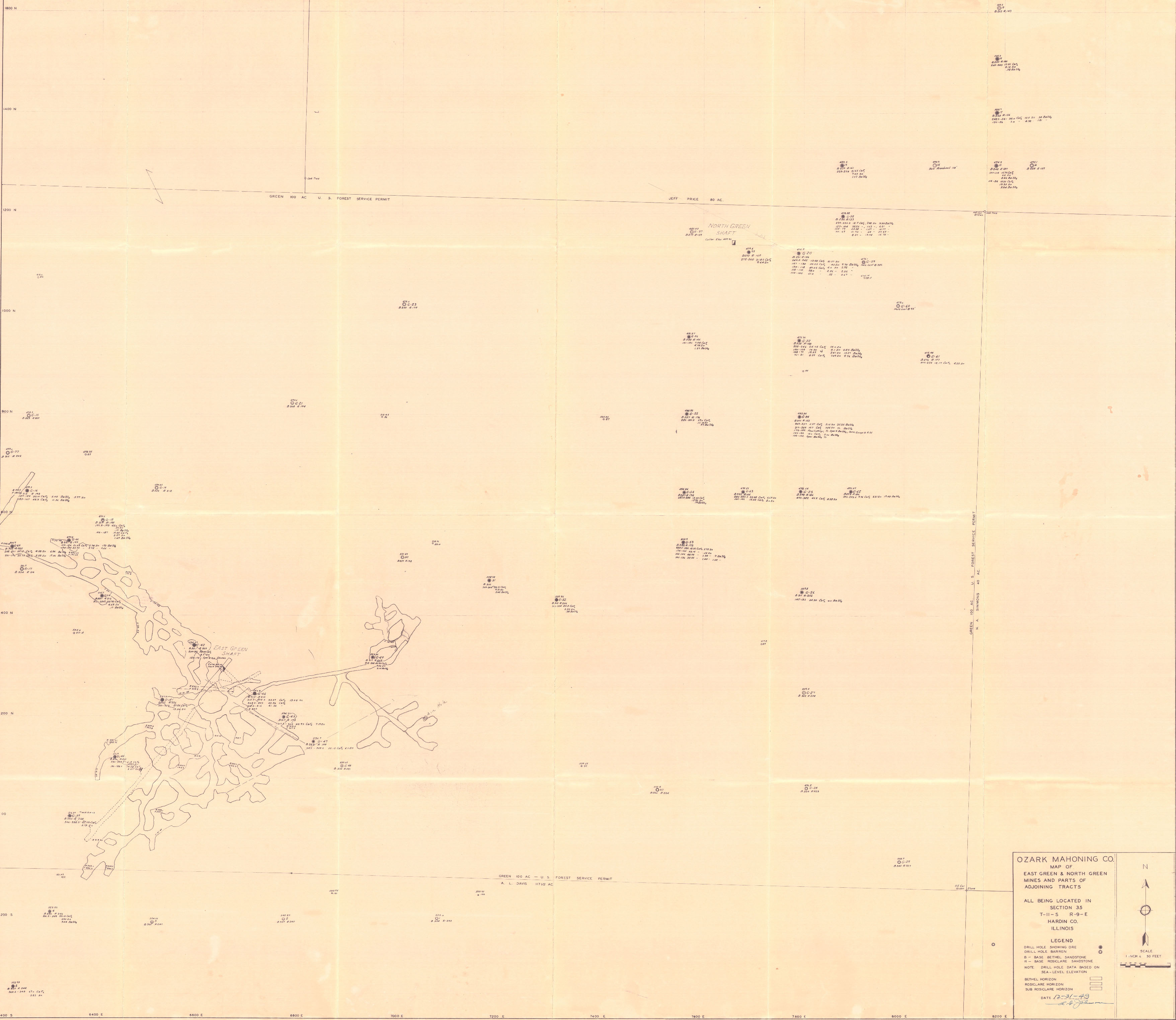
| Company: | Ozark-Mahoning Company | |
| Mine Name: | ||
| More Info: | EastGreenNorthGreenMinesPlan.jpg | |
| Click to download Full ResolutionThese files are true to scale and most are georegistered for gis software. File Type: Map Caption: Ozark-Mahoning Company Map of East Green & North Green Mines and parts of adjoining tracts | ||
 These files may not be true to scale and are not georgistered. These files may not be true to scale and are not georgistered.
|
Mine Index: | 10082976 |
|---|---|---|
| Company: | ||
| Mine Name: | ||
| More Info: | HardinCounty OZM GeoDrillMap.jpg | |
| Click to download Full ResolutionThese files are true to scale and most are georegistered for gis software. File Type: Map Caption: Map showing Stratigraphic Position of Mineralized rocks in Mines and test borings. Mahoning Mining Company Property and vicinity. (ISGS Map) | ||
 These files may not be true to scale and are not georgistered. These files may not be true to scale and are not georgistered.
|
Mine Index: | 10082976 |
|---|---|---|
| Company: | Ozark-Mahoning Company | |
| Mine Name: | ||
| More Info: | Hill Ledford Plan 1961.jpg | |
| Click to download Full ResolutionThese files are true to scale and most are georegistered for gis software. File Type: Map Caption: Ozark-Mahoning Company Map of Hill-Letford Tract and surrounding acreage | ||
References
|
|
|
|
|
|
|
External Links
Mineral Resources Data System (MRDS) USGS Link
https://mrdata.usgs.gov/mrds/show-mrds.php?dep id=10082976
Also referenced as 10266404