Mine Index 10082988 Ozark-Mahoning Company, Heavy Media Mine, Meavy Media Shaft and Mill, H. M. Mine No. 6, Oxford Shafts
| Disclaimer | ||
|---|---|---|
| S-T-R | 26(NWSW)-11S-9E | |
| County: | Hardin | |
| Quadrangle: | Saline Mines | |
| District: | Fluorspar District | |
| Subdistrict: | ||
Mine Index Number: 10082988
| ISGS ID: | MSHA ID: | ||
|---|---|---|---|
| MAS ID: | 170690125 | MRDS ID: | W062468 |
| Company Name: | Ozark-Mahoning Company | ||
| Mine/Site Name: | Heavy Media Mine, Meavy Media Shaft and Mill, H. M. Mine No. 6, Oxford Shafts | ||
| Active/Abandoned: | Abandoned | ||
| Start Date: | circa 1982 | End Date: | Unknown |
| Commodity Type: | Metallic, Non-Metallic | ||
| Commodity: | Barite(Barytes), Fluorspar, Lead, Zinc | ||
| Minerals Present: | Galena, Barite, Calcite, Fluorite, Quartz, Sphalerite | ||
| Type of Mine: | Underground | ||
| District: | Fluorspar District | Subdistrict: | |
| County: | Hardin | ||
| Section/Township/Range: | 26(NWSW)-11S-9E | ||
| Latitude,Longitude: | 37.52313,-88.18975 | ||
| Unit(s) Mined: | Lower Chesterian Series, Glen Dean Limestone, Renault Limestone | ||
| Feature(s) Mined: | |||
| MRDS Link: | https://mrdata.usgs.gov/mrds/show-mrds.php?dep id=10082988 | ||
| Mindat link: | |||
Discussion
MINED BY THE ROOM AND PILLAR METHOD.
| Ore body information | |
|---|---|
| Strike | N40W |
| Dip | 02N |
| Thickness | 3M |
| Depth to top | 60M |
| Width | 500M |
| Length | 4000M |
| Area | 26HA |
| Field | Value |
| Type of Orebody #1 | REPLACEMENT |
| Shape of Orebody #1 | TABULAR |
| Primary mode of Origin | HYDROTHERMAL |
| Primary Ore Control | FAULTING |
| Secondary Ore Control | BEDDING |
| Degree of Wallrock Alter. | UNKNOWN |
| Strike And Dip | N40W |
| Avg. Thick. Unconsol. Mat. | 30 |
| Min. Thick. Unconsol. Mat. | 30 |
| Total Surface Area (HA) | 26 |
| Date of Last Modification | 830126 |
OTHER = JOINT SYSTEM.
Year of First Production: 1939
Milling Method: Flotation
OZARK-MAHONING COMPANY IS A SUBSIDIARY OF PENNWALT CORPORATION (100%).
| Production statistics | |
|---|---|
| Year | 1970 |
| Description | 103836 Metric Tons Ore |
| Year | 1971 |
| Description | 159740 Metric Tons Ore |
| Year | 1972 |
| Description | 115667 Metric Tons Ore |
| Year | 1973 |
| Description | 109823 Metric Tons Ore |
| Year | 1974 |
| Description | 106218 Metric Tons Ore |
| Year | 1975 |
| Description | 71037 Metric Tons Ore |
| Year | 1976 |
| Description | 285893 Metric Tons Ore |
| Year | 1977 |
| Description | 275849 Metric Tons Ore |
| Year | 1978 |
| Description | 235550 Metric Tons Ore |
| Year | 1979 |
| Description | 257798 Metric Tons Ore |
MILL OUTPUT VALUES HAVE BEEN ROUNDED FROM PRECISE VALUES
TOTAL IN SITU RESERVE AS OF JANUARY 1980 = 464000 MT.
RESOURCES DEPLETED ALTERNATE NAMES: H.M. MINE NO.6, H.M. MINE, OXFORD SHAFTS, HEAVY MEDIA SHAFT AND MILL, AND H.M. SHAFT.
| Workings at the site | |
|---|---|
| Type of workings | Underground |
| Overall depth | 91M |
| Field | Value |
| MAS Development Schedule # | 1 |
| Mining Record # | 1 |
| Status of Mining Method | ACTUAL |
| Mining Method | ROOM AND PILLAR 10-34 |
| Percent Waste Rock | 0 |
| Percent Recovery | 85 |
| Hardness of Rock | HARDROCK FISSURED WITH MODERATE WATER |
| Rock Characteristics | MULTIPLE SYSTEMS OF WEAKNESS PLANES |
| Rock Support Chars. | UNSUPPORTING NO SLOUGH |
| Mine Support Chars. | POST, HEADBOARD, CAPS, ROOF BOLTS |
| Number of Shafts | 10 |
| Avg. Length of Adits (m) | 90 |
| Number of Adits | 1 |
| 1st Condition of Workings | OPEN |
| Capacity | 272 |
| Capacity Units | MT ORE/DAY |
| Unit Production Cost | 9.8 |
| Units of Production | $/MT ORE |
| Operating Days per Year | 250 |
| Operating Shifts per Day | 1 |
| Year of Information | 1981 |
EXACT DIP IS 2.5 DEGREES NORTHEAST.
Mine Data/Information
 These files may not be true to scale and are not georgistered. These files may not be true to scale and are not georgistered.
|
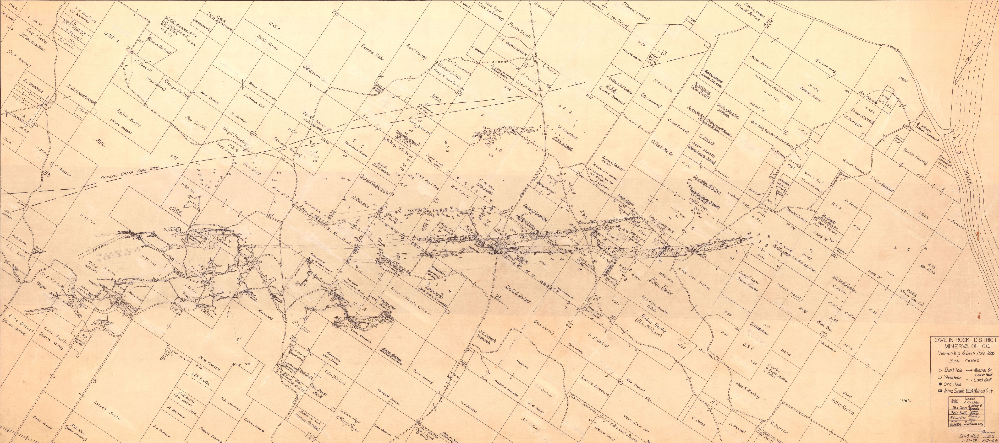
Mine Index: | 10082988 |
|---|---|---|
| Company: | Minerva Oil Company | |
| Mine Name: | ||
| More Info: | CaveInRock MIN PropertyDrillHole.jpg | |
| Click to download Full ResolutionThese files are true to scale and most are georegistered for gis software. File Type: Map Caption: Cave In Rock District Minerva Oil Company | ||
 These files may not be true to scale and are not georgistered. These files may not be true to scale and are not georgistered.
|
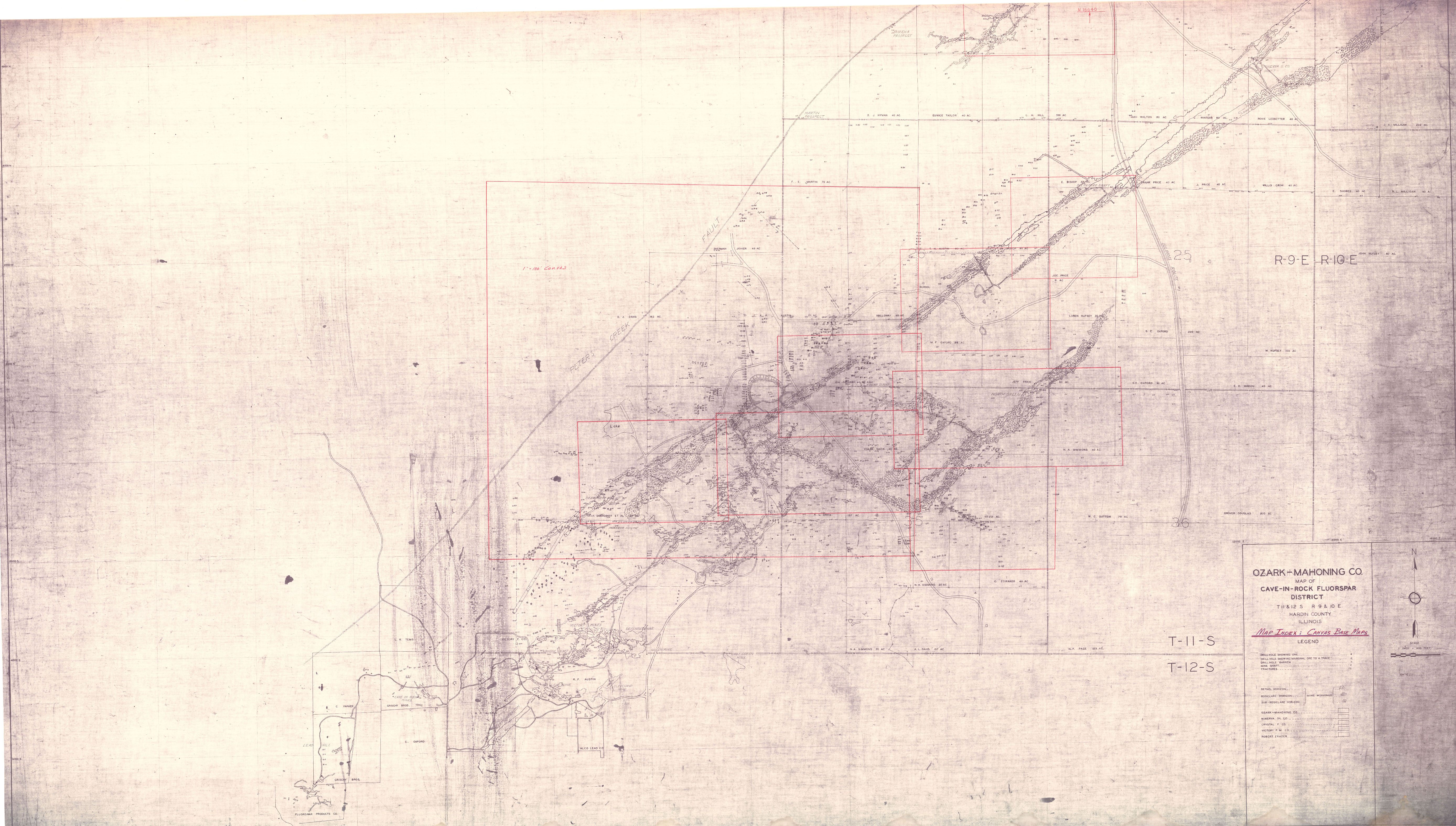
Mine Index: | 10082988 |
|---|---|---|
| Company: | ||
| Mine Name: | ||
| More Info: | CaveInRockFluorsparDistrict OZM.jpg | |
| Click to download Full ResolutionThese files are true to scale and most are georegistered for gis software. File Type: Map Caption: Ozark-Mahoning Company Map of Cave-In-Rock district | ||
References
|
|
|
|
|
|
External Links
Mineral Resources Data System (MRDS) USGS Link
https://mrdata.usgs.gov/mrds/show-mrds.php?dep id=10082988
Also referenced as 10145164