Mine Index 10083004 Knox Spar Corporation, Knox Fluorite Mine
| Disclaimer | ||
|---|---|---|
| S-T-R | 11(NESWSW)-11S-7E | |
| County: | Hardin | |
| Quadrangle: | Herod | |
| District: | Fluorspar District | |
| Subdistrict: | Rose Creek Subdistrict | |
Mine Index Number: 10083004
| ISGS ID: | MSHA ID: | ||
|---|---|---|---|
| MAS ID: | 170690027 | MRDS ID: | W062487 |
| Company Name: | Knox Spar Corporation | ||
| Mine/Site Name: | Knox Fluorite Mine | ||
| Active/Abandoned: | Abandoned | ||
| Start Date: | circa 1973 | End Date: | Unknown |
| Commodity Type: | Non-Metallic | ||
| Commodity: | Fluorspar | ||
| Minerals Present: | Galena, Fluorite, Sphalerite | ||
| Type of Mine: | Underground | ||
| District: | Fluorspar District | Subdistrict: | Rose Creek Subdistrict |
| County: | Hardin | ||
| Section/Township/Range: | 11(NESWSW)-11S-7E | ||
| Latitude,Longitude: | 37.57396,-88.40921 | ||
| Unit(s) Mined: | Chesterian Series, Grove Church Shale, Tar Springs Sandstone | ||
| Feature(s) Mined: | |||
| MRDS Link: | https://mrdata.usgs.gov/mrds/show-mrds.php?dep id=10083004 | ||
| Mindat link: | |||
Primary source
Discussion
The Knox Mine was located about 775 feet southwest of the Conley Shaft. It was probably along the same fault present at the Rose Creek Mine that trends N50°–60°E and dips steeply to the southeast (Weller et al. 1952). Near the Knox Mine, the fault is normal, with displacement down to the southeast approximately 400 feet. The Golconda Limestone is present on the northwest side of the fault, and the Waltersburg Sandstone is present on the southeast side. The mine was operated by the Knox Spar Company and produced siliceous fluorspar from a vein about 4 feet wide. Burmeister (1952) indicated that the shaft had been extended to the 300-foot level (Figure 10). Ozark-Mahoning mine maps indicate that working levels were at 121, 167, 237, and 300 feet. Drilling by the U.S. Bureau of Mines (K-4 and K-2) southeast of the mine indicated that disseminated spar was present in the Bethel Sandstone. The disseminated ore, if projected southwesterly, is in line with the east orebody present at the Rose Creek Mine.
Mine Data/Information
- Other Data Files
File Type: Figure
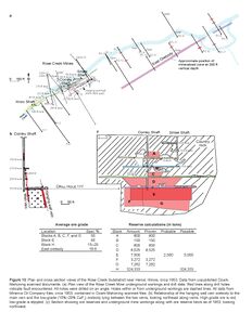
Caption: Figure 10 Plan and cross section views of the Rose Creek Subdistrict near Herod, Illinois, circa 1953. Data from unpublished Ozark- Mahoning scanned documents.
(a) Plan view of the Rose Creek Mine underground workings and drill data. Red lines along drill holes indicate fault encountered. All holes were drilled on an angle. Holes within or from underground workings are dashed lines. All data from Minerva Oil Company files, circa 1953, contained in Ozark-Mahoning scanned files.
(b) Relationship of the hanging wall vein orebody to the main vein and the low-grade (15%–20% CaF2) orebody lying between the two veins, looking northeast along veins. High-grade ore is red; low-grade is stippled.
(c) Section showing ore reserves and underground mine workings along with ore reserve block as of 1953, looking northwest.
Credit: Copyright © University of Illinois Board of Trustees
Publication: Circular 604

Mine Data
Faulting present
GALENA AND SPHALERITE WERE ONLY MINOR MINERALS.
| Mineral occurrence model information | |
|---|---|
| Model code | 174 |
| USGS model code | 26b |
| Deposit model name | Fluorspar deposits (fluorite veins) |
THE DEPOSIT IS PROBABLY ON THE SAME FAULT AS THE ROSE CREEK MINE.'
THERE WAS COMMERCIAL PRODUCTION.
Overall depth 80.77M
ECON.COM: THE ORE IS SILICEOUS.
THE VEIN AVERAGES 4 FT IN WIDTH.
References
|
|
|
External Links
Mineral Resources Data System (MRDS) USGS Link
https://mrdata.usgs.gov/mrds/show-mrds.php?dep id=10083004
Also referenced as 10217418