Mine Index 10083008 Martin Prospect, F E Martin Prospect
| Disclaimer | ||
|---|---|---|
| S-T-R | 23(SWSWSW)-11S-9E | |
| County: | Hardin | |
| Quadrangle: | Saline Mines | |
| District: | Fluorspar District | |
| Subdistrict: | Cave-in-Rock Subdistrict | |
Mine Index Number: 10083008
| ISGS ID: | MSHA ID: | ||
|---|---|---|---|
| MAS ID: | 170690071 | MRDS ID: | W062492 |
| Company Name: | |||
| Mine/Site Name: | Martin Prospect, F E Martin Prospect | ||
| Active/Abandoned: | Abandoned | ||
| Start Date: | Unknown | End Date: | Unknown |
| Commodity Type: | Non-Metallic | ||
| Commodity: | Fluorspar | ||
| Minerals Present: | Galena, Fluorite | ||
| Type of Mine: | Prospect, Underground, Occurrence | ||
| District: | Fluorspar District | Subdistrict: | Cave-in-Rock Subdistrict |
| County: | Hardin | ||
| Section/Township/Range: | 23(SWSWSW)-11S-9E | ||
| Latitude,Longitude: | 37.54146,-88.18809 | ||
| Unit(s) Mined: | Chesterian Series, Glen Dean Limestone, Renault Limestone | ||
| Feature(s) Mined: | Peters_Creek_Fault_Zone | ||
| MRDS Link: | https://mrdata.usgs.gov/mrds/show-mrds.php?dep id=10083008 | ||
| Mindat link: | |||
Discussion
Faulting present
THE VEIN TRENDS N 40 E AND DIPS TO THE NW AT THIS SITE.
Ore body information: BLANKET
Overall depth 11.58M
THE PROSPECT SHAFT EXPOSED VEINLETS OF FLUORSPAR ON PETERS CREEK FAULT ZONE.
BEDDED FLUORITE DEPOSITS FORM PRIMARILY FORM SELECTIVE REPLACEMENT OF LIMESTONE BEDS. WELLER AND OTHERS (1952) LIST THIS AS A VEIN DEPOSIT.
Mine Data/Information
 These files may not be true to scale and are not georgistered. These files may not be true to scale and are not georgistered.
|
Mine Index: | 10083008 |
|---|---|---|
| Company: | Ozark-Mahoning Company | |
| Mine Name: | ||
| More Info: | CaveInRockFluorsparDistrict1956 OZM.jpg | |
| Click to download Full ResolutionThese files are true to scale and most are georegistered for gis software. File Type: Map Caption: Ozark-Mahoning Company Map of Cavie-In-Rock Fluorspar District | ||
 These files may not be true to scale and are not georgistered. These files may not be true to scale and are not georgistered.
|
Mine Index: | 10083008 |
|---|---|---|
| Company: | ||
| Mine Name: | ||
| More Info: | CaveInRockHillLedfordMinervaPlanDrill.jpg | |
| Click to download Full ResolutionThese files are true to scale and most are georegistered for gis software. File Type: Map Caption: Ozark-Mahoning Company Map of Hill-Ledford Tract and Surrounding Acreages | ||
 These files may not be true to scale and are not georgistered. These files may not be true to scale and are not georgistered.
|
Mine Index: | 10083008 |
|---|---|---|
| Company: | Ozark-Mahoning Company | |
| Mine Name: | ||
| More Info: | CaveInRockPlanDrill.jpg | |
| Click to download Full ResolutionThese files are true to scale and most are georegistered for gis software. File Type: Map Caption: Ozark-Mahoning Company Map of Cave-in-Rock Fluorspar District | ||
 These files may not be true to scale and are not georgistered. These files may not be true to scale and are not georgistered.
|
Mine Index: | 10083008 |
|---|---|---|
| Company: | Mahoning Mining Company | |
| Mine Name: | ||
| More Info: | CaveInRockPlanDrillOriginal.jpg | |
| Click to download Full ResolutionThese files are true to scale and most are georegistered for gis software. File Type: Map Caption: Mahoning Ming Company Map of Cave-in-Rock Fluorspar District | ||
 These files may not be true to scale and are not georgistered. These files may not be true to scale and are not georgistered.
|
Mine Index: | 10083008 |
|---|---|---|
| Company: | ||
| Mine Name: | ||
| More Info: | HardinCounty OZM GeoDrillMap.jpg | |
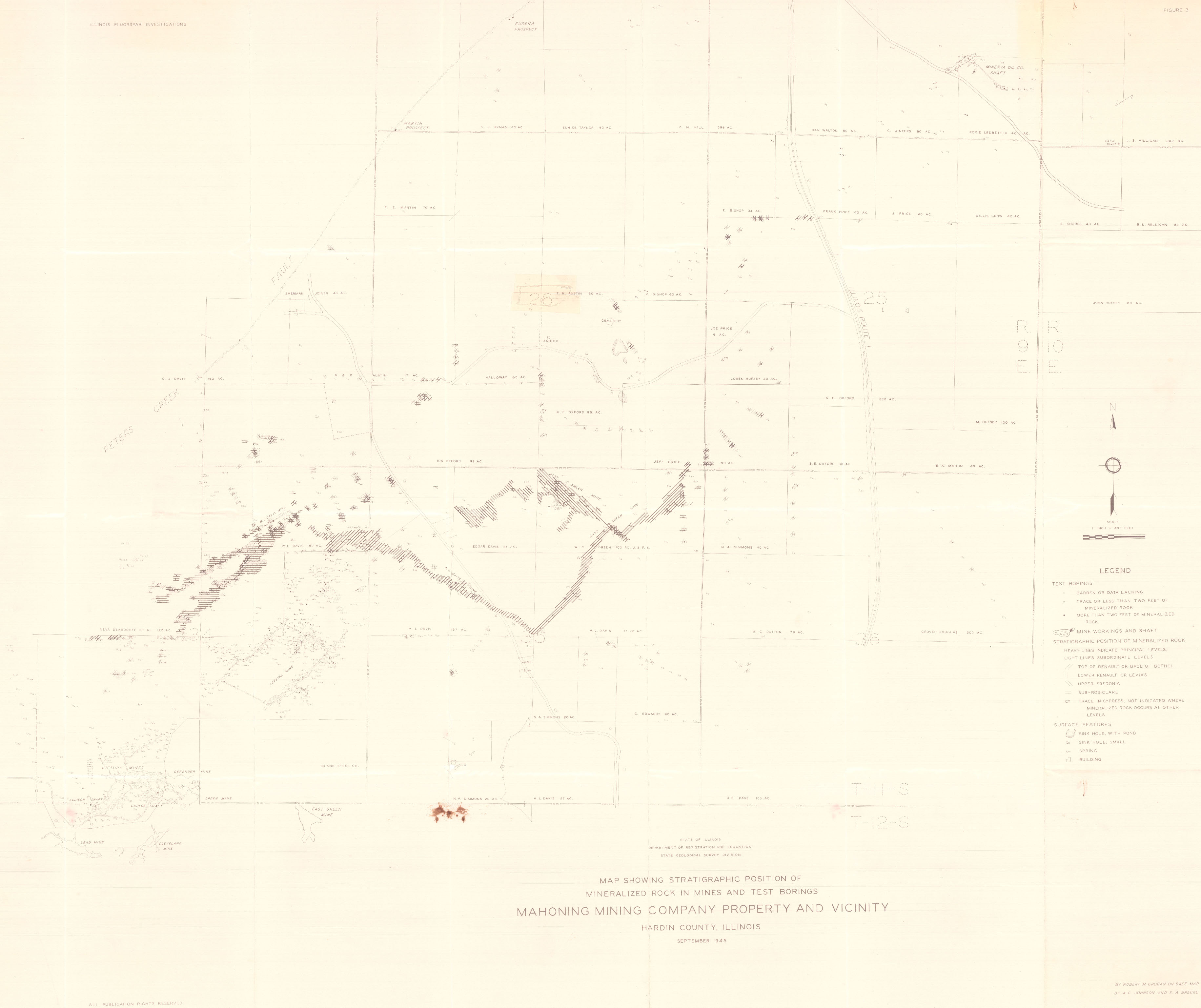
| Click to download Full ResolutionThese files are true to scale and most are georegistered for gis software. File Type: Map Caption: Map showing Stratigraphic Position of Mineralized rocks in Mines and test borings. Mahoning Mining Company Property and vicinity. (ISGS Map) | ||
 These files may not be true to scale and are not georgistered. These files may not be true to scale and are not georgistered.
|
Mine Index: | 10083008 |
|---|---|---|
| Company: | Ozark-Mahoning Company | |
| Mine Name: | ||
| More Info: | Hill Ledford Plan 1961.jpg | |
| Click to download Full ResolutionThese files are true to scale and most are georegistered for gis software. File Type: Map Caption: Ozark-Mahoning Company Map of Hill-Letford Tract and surrounding acreage | ||
References
|
|
|
|
|
External Links
Mineral Resources Data System (MRDS) USGS Link
https://mrdata.usgs.gov/mrds/show-mrds.php?dep id=10083008
Also referenced as 10217503