Mine Index 10083011 Ozark-Mahoning Company, Minerva No. 1 Mine
| Disclaimer | ||
|---|---|---|
| S-T-R | 13(NW)-11S-9E | |
| County: | Hardin | |
| Quadrangle: | Saline Mines | |
| District: | Fluorspar District | |
| Subdistrict: | Cave-in-Rock Subdistrict | |
Mine Index Number: 10083011
| ISGS ID: | MSHA ID: | ||
|---|---|---|---|
| MAS ID: | 170690123 | MRDS ID: | W062495 |
| Company Name: | Ozark-Mahoning Company | ||
| Mine/Site Name: | Minerva No. 1 Mine | ||
| Active/Abandoned: | Active | ||
| Start Date: | circa 1988 | End Date: | Unknown |
| Commodity Type: | Metallic, Non-Metallic | ||
| Commodity: | Barite(Barytes), Cadmium, Fluorspar, Gallium, Germanium, Lead, Silver | ||
| Minerals Present: | Fluorite, Sphalerite | ||
| Type of Mine: | Unknown | ||
| District: | Fluorspar District | Subdistrict: | Cave-in-Rock Subdistrict |
| County: | Hardin | ||
| Section/Township/Range: | 13(NW)-11S-9E | ||
| Latitude,Longitude: | -88.15892,37.5425699999998 | ||
| Unit(s) Mined: | Lower Chesterian Series, Glen Dean Limestone, Renault Limestone | ||
| Feature(s) Mined: | |||
| MRDS Link: | https://mrdata.usgs.gov/mrds/show-mrds.php?dep id=10083011 | ||
| Mindat link: | |||
Discussion
CADMIUM AND GALLIUM OCCUR IN SPHALERITE FROM THE MINERVA MINE.
Geologic Structures: Collapse Structures Formed During Mineralization.
Ore body information: BLANKET Controls for ore emplacement: Selective Replacement Of Limestone Beds.
MINED BY THE ROOM AND PILLAR METHOD.
BEDDED FLUORITE DEPOSITS FORM PRIMARILY FROM SELECTIVE REPLACEMENT OF LIMESTONE BEDS.
Year of Information: 1995
SOLD TO OZARK-MAHONING COMPANY IN JAN 1988.
M1C1 RESERVES TAKEN FROM ADIT TABLES - JUNE 93.
WILL USE ROSICLARE MILL.
CLOSED AND FLOODED 1982. FOR SALE SINCE 1984. SOLD IN 1988. AS OF MSHA.DBF 02/95 MINE IS IN PRODUCTION. LISTED BY MSHA, 02/95 AS MINES I.D. #1100791 UNDER OLD NAME; OF MINERVA NO. 1 MINE. ON THE MSHA 11/82 PRODUCERS LIST ID # WAS #1102364. THIS # WILL BECOME THE RESP_ID #. BASIC INFORMATION ON THIS PROPERTY WILL BE REBUILT FROM PREVIOUS EVALUATION REPORTS. THE COSTING, OPERATION AND RESERVES DATA WILL PROBABLY BE TREATED ALONG WITH THE DENTON (SEQ.#0170690144) AND ANNABELL LEE (SEQ.#0170690162) MINES UNDER THE ROSICLARE MILL FILE (SEQ.#0170699908). AN UPDATE OF THESE MINES WAS DONE IN THIS MANNER BY MAFO IN 1987 BUT NOT INCLUDED ON THE MAS DATABASE.- 15JUNE93. ORIGINAL EVAL USED SAME MILL AS SPIVEY #0170690127
Mining method Open Stope - Room and Pillar Milling method Flotation
Mine Data/Information
 These files may not be true to scale and are not georgistered. These files may not be true to scale and are not georgistered.
|
Mine Index: | 10083011 |
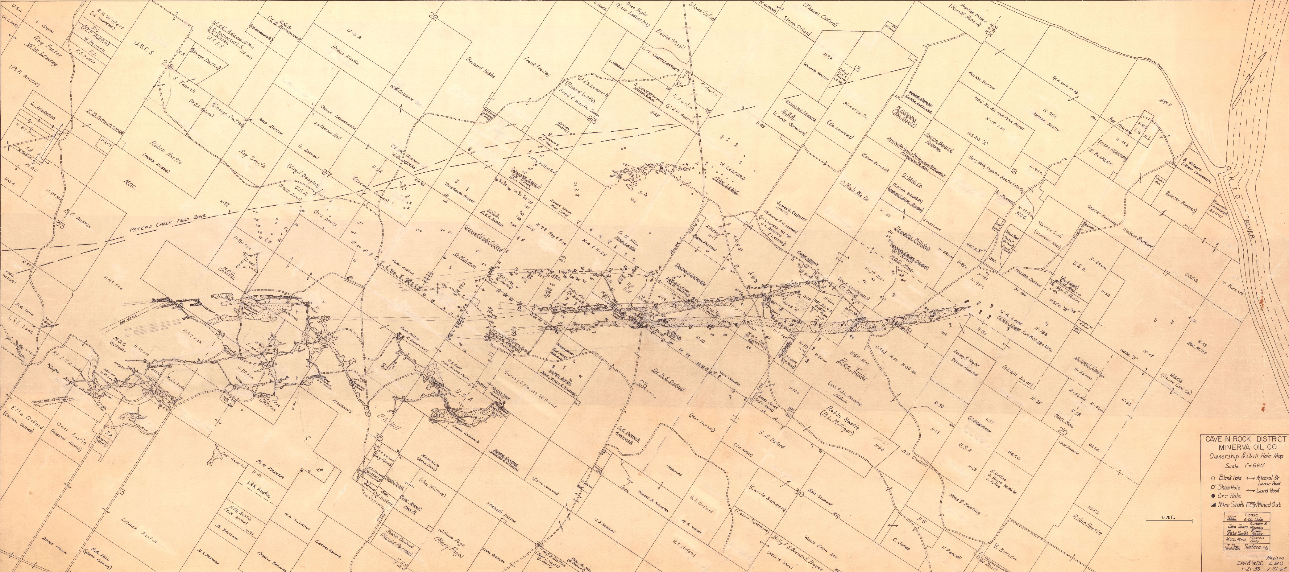
|---|---|---|
| Company: | Minerva Oil Company | |
| Mine Name: | ||
| More Info: | CaveInRock MIN PropertyDrillHole.jpg | |
| Click to download Full ResolutionThese files are true to scale and most are georegistered for gis software. File Type: Map Caption: Cave In Rock District Minerva Oil Company | ||
 These files may not be true to scale and are not georgistered. These files may not be true to scale and are not georgistered.
|
Mine Index: | 10083011 |
|---|---|---|
| Company: | ||
| Mine Name: | ||
| More Info: | CaveInRockFluorsparDistrict OZM.jpg | |
| Click to download Full ResolutionThese files are true to scale and most are georegistered for gis software. File Type: Map Caption: Ozark-Mahoning Company Map of Cave-In-Rock district | ||
 These files may not be true to scale and are not georgistered. These files may not be true to scale and are not georgistered.
|
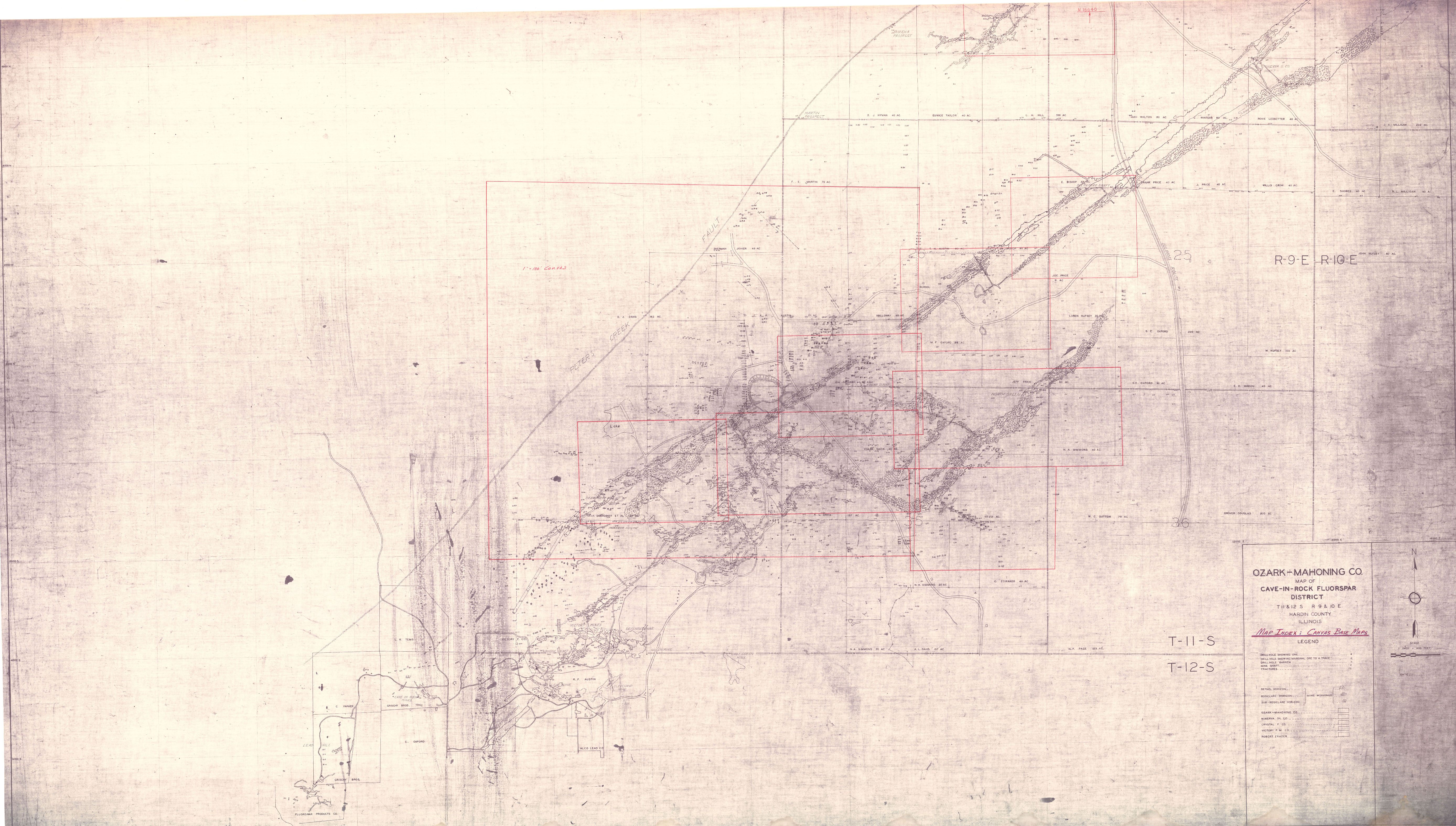
Mine Index: | 10083011 |
|---|---|---|
| Company: | Ozark-Mahoning Company | |
| Mine Name: | ||
| More Info: | CaveInRockFluorsparDistrict1956 OZM.jpg | |
| Click to download Full ResolutionThese files are true to scale and most are georegistered for gis software. File Type: Map Caption: Ozark-Mahoning Company Map of Cavie-In-Rock Fluorspar District | ||
 These files may not be true to scale and are not georgistered. These files may not be true to scale and are not georgistered.
|
Mine Index: | 10083011 |
|---|---|---|
| Company: | ||
| Mine Name: | ||
| More Info: | CaveInRockHillLedfordMinervaPlanDrill.jpg | |
| Click to download Full ResolutionThese files are true to scale and most are georegistered for gis software. File Type: Map Caption: Ozark-Mahoning Company Map of Hill-Ledford Tract and Surrounding Acreages | ||
 These files may not be true to scale and are not georgistered. These files may not be true to scale and are not georgistered.
|
Mine Index: | 10083011 |
|---|---|---|
| Company: | Ozark-Mahoning Company | |
| Mine Name: | ||
| More Info: | CaveInRockPlanDrill.jpg | |
| Click to download Full ResolutionThese files are true to scale and most are georegistered for gis software. File Type: Map Caption: Ozark-Mahoning Company Map of Cave-in-Rock Fluorspar District | ||
 These files may not be true to scale and are not georgistered. These files may not be true to scale and are not georgistered.
|
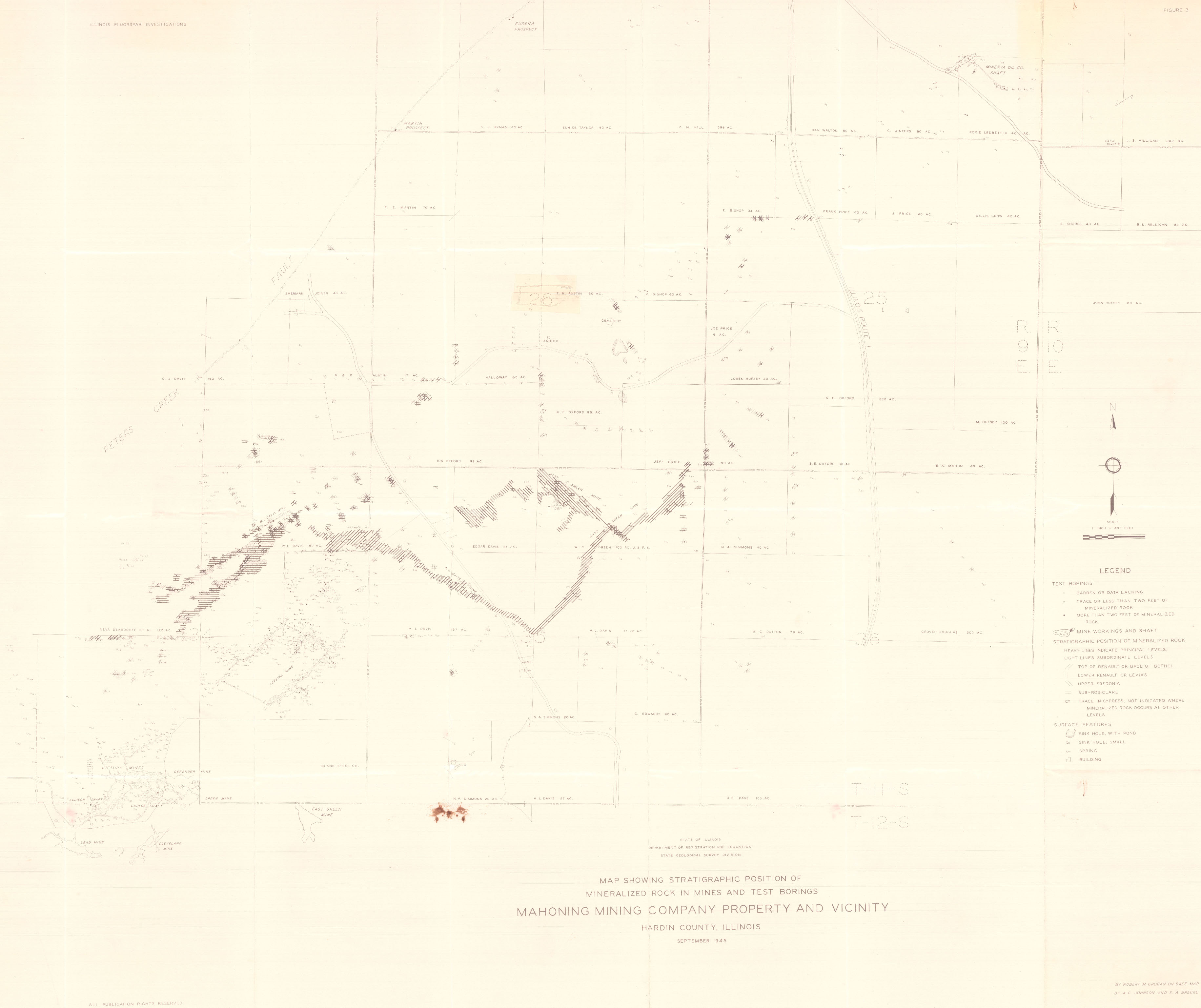
Mine Index: | 10083011 |
|---|---|---|
| Company: | Mahoning Mining Company | |
| Mine Name: | ||
| More Info: | CaveInRockPlanDrillOriginal.jpg | |
| Click to download Full ResolutionThese files are true to scale and most are georegistered for gis software. File Type: Map Caption: Mahoning Ming Company Map of Cave-in-Rock Fluorspar District | ||
 These files may not be true to scale and are not georgistered. These files may not be true to scale and are not georgistered.
|
Mine Index: | 10083011 |
|---|---|---|
| Company: | ||
| Mine Name: | ||
| More Info: | HardinCounty OZM GeoDrillMap.jpg | |
| Click to download Full ResolutionThese files are true to scale and most are georegistered for gis software. File Type: Map Caption: Map showing Stratigraphic Position of Mineralized rocks in Mines and test borings. Mahoning Mining Company Property and vicinity. (ISGS Map) | ||
 These files may not be true to scale and are not georgistered. These files may not be true to scale and are not georgistered.
|
Mine Index: | 10083011 |
|---|---|---|
| Company: | Ozark-Mahoning Company | |
| Mine Name: | ||
| More Info: | Hill Ledford Plan 1961.jpg | |
| Click to download Full ResolutionThese files are true to scale and most are georegistered for gis software. File Type: Map Caption: Ozark-Mahoning Company Map of Hill-Letford Tract and surrounding acreage | ||
References
|
|
|
|
|
External Links
Mineral Resources Data System (MRDS) USGS Link
https://mrdata.usgs.gov/mrds/show-mrds.php?dep id=10083011
Also referenced as 10120955