Category:Chatham-Quadrangle: Difference between revisions
Alan.Myers (talk | contribs) No edit summary |
Alan.Myers (talk | contribs) No edit summary |
||
| Line 12: | Line 12: | ||
Both the Springfield and the Herrin coal seams were mined in this quadrangle. The mines in the northern part of the quadrangle operated in the Springfield Coal, where it is approximately 250 feet deep and averages 5 feet 10 inches in thickness. Many mines in the Springfield Coal, in this part of the state, have encountered numerous clay dikes. The mines at Chatham and in the southern part of the quadrangle mined the Herrin, which averages 7 feet in thickness at a depth of 240 to 270 feet. | Both the Springfield and the Herrin coal seams were mined in this quadrangle. The mines in the northern part of the quadrangle operated in the Springfield Coal, where it is approximately 250 feet deep and averages 5 feet 10 inches in thickness. Many mines in the Springfield Coal, in this part of the state, have encountered numerous clay dikes. The mines at Chatham and in the southern part of the quadrangle mined the Herrin, which averages 7 feet in thickness at a depth of 240 to 270 feet. | ||
<br> | <br> | ||
==Map and Directory PDF Download== | |||
[https://wikiimage.isgs.illinois.edu/ilmines/webfiles/topo-mines/chatham.pdf Coal Mines In Illinois Chatham Quadrangle]</br> | |||
==Mines that Appear on the Chatham Quadrangle== | ==Mines that Appear on the Chatham Quadrangle== | ||
{{#css: | {{#css: | ||
Revision as of 15:37, June 19, 2020
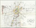
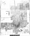
MINING IN THE CHATHAM QUADRANGLE
Mining began in this quadrangle in 1885 with the sinking of a shaft for the mine at Chatham. The first production was 3,139 tons in 1886 and the property was mined until 1907 when it was abandoned. Subsequently, Peabody mining operations, with shafts in the Springfield area, mined into the quadrangle, as did the Panther Creek Mine from the Divernon area to the south.
Both the Springfield and the Herrin coal seams were mined in this quadrangle. The mines in the northern part of the quadrangle operated in the Springfield Coal, where it is approximately 250 feet deep and averages 5 feet 10 inches in thickness. Many mines in the Springfield Coal, in this part of the state, have encountered numerous clay dikes. The mines at Chatham and in the southern part of the quadrangle mined the Herrin, which averages 7 feet in thickness at a depth of 240 to 270 feet.
Map and Directory PDF Download
Coal Mines In Illinois Chatham Quadrangle
Mines that Appear on the Chatham Quadrangle
Unlocated Mines in Sangamon County
| Mine Index | Coal Company, Mine Name | City |
|---|---|---|
| 3361 | W. H. Golloday, Golloday Mine N. C. Antle, Antle Mine Golladay and Brandt, Golladay and Brandt Mine Gordon and Duncan, Gordon and Duncan Mine John P. Gordon, Gordon Mine W. U. Whitehurst, Whitehurst Mine |
Pages in category "Chatham-Quadrangle"
The following 5 pages are in this category, out of 5 total.
Media in category "Chatham-Quadrangle"
The following 11 files are in this category, out of 11 total.
 FLB sangamon.jpg 3,398 × 2,654; 1.22 MB
 M0038 4103S33 i51 50 s3.jpg 3,398 × 1,742; 1.51 MB
 M0038 coalreport 1888p415.pdf 1,589 × 1,297; 1,004 KB
 M0038 minenotes.pdf 733 × 1,175, 14 pages; 1.57 MB
 M0038.jpg 2,784 × 3,398; 3.29 MB
 M0193 minenotes.pdf 727 × 1,166, 17 pages; 2.07 MB
 M3337 coalreport 1892p576.pdf 1,487 × 1,208; 369 KB
 M3337 i51 33.jpg 3,398 × 3,233; 1.86 MB
 M3337 minenotes.pdf 727 × 1,166, 8 pages; 866 KB
 M3340 i51 47.jpg 3,398 × 3,239; 2.37 MB
 M3340 minenotes.pdf 718 × 1,160, 13 pages; 1.38 MB


