Mine Index Number: 3337
| Company Name:
|
Illinois Collieries
|
| Mine Name:
|
Illlinos Collieries No. 3 Mine
|
| Start Date:
|
1885
|
End Date:
|
June 1907
|
| Type of Mine:
|
Underground
|
| Total acres shown:
|
128
|
| Acres after map date:
|
|
General Area of mining acres shown:
|
|
|
|
Shaft, Slope, Drift or Tipple Location(s)
| Type
|
County
|
Township-Range
|
Section
|
Part Section
|
| Main shaft
|
Sangamon
|
14N 6W
|
13
|
SE NE NE
|
| Escape shaft
|
Sangamon
|
14N 6W
|
13
|
SE NE NE
|
Geology
Geological Problems Reported
Production
| Company
|
Mine Name
|
Date
|
Production (tons)
|
|
|
|
|
|
| Total Production: 784,061
|
Production Notes
Coal Report production (if available)
Sources of Data
| Company, 4103.S33 i5.1-33
|
6-1907
|
1:2400
|
1:2400
|
Final The northwest portion of the final map is incomplete, containing areas labeled as “old works” for which no outer boundary is shown. The boundaries for this area are based on the property owned by the company. The area shown on the accompanying map is the approximate size expected for the reported production. This suggests that the mine outline is complete.
|
| Federal Land Bank Report
|
1934
|
1:158400
|
1:158400
|
Secondary source
|
Annotated Bibliography (Data source - brief description of information)
Mine Notes
Mine Images
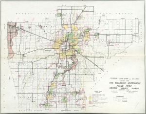
Federal Land Bank Report: Sangamon County
Map Date: 1934
Coal Co.: Illinois Collieries
Mine Name: Illinois Collieries No. 3 Mine
Full Res Download
Company: 4103.S33 i5.1-33
Map Date: 6-1907
Coal Co.: Illinois Collieries
Mine Name: Illinois Collieries No. 3 Mine
Full Res Download
Photographs
Additional Notes
Additional Notes


