3507: Difference between revisions
Alan.Myers (talk | contribs) No edit summary |
Alan.Myers (talk | contribs) No edit summary |
||
| Line 14: | Line 14: | ||
|Latitude=38.5429778800001 | |Latitude=38.5429778800001 | ||
|Longitude=-89.942212551 | |Longitude=-89.942212551 | ||
|Zoom= | |Zoom=14 | ||
}} | }} | ||
==Shaft, Slope, Drift or Tipple Location(s)== | ==Shaft, Slope, Drift or Tipple Location(s)== | ||
Revision as of 12:23, December 11, 2020
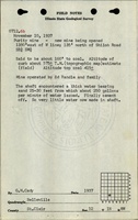
Mine Index Number: 3507
| Company Name: | Purity Coal Company | ||
|---|---|---|---|
| Mine Name: | Purity Mine | ||
| Start Date: | 1938 | End Date: | March 1955 |
| Type of Mine: | Underground | ||
| Total acres shown: | 52 | ||
| Acres after map date: | General Area of mining acres shown: | ||
Shaft, Slope, Drift or Tipple Location(s)
| Type | County | Township-Range | Section | Part Section |
|---|
| Main shaft | St. Clair | 1N 8W | 12 | NW SE SW |
| Air shaft | St. Clair | 1N 8W | 12 | NW SE SW |
Geology
| Thickness (ft) | |||||
|---|---|---|---|---|---|
| Seam | Depth (ft) | Min | Max | Ave | Mining Method |
| Herrin | 187 | 7.0 | MRP |
Geological Problems Reported
Production
| Company | Mine Name | Date | Production (tons) |
| Purity Coal Company | Purity | 1938-1955 | 283,535 |
Production Notes
Coal Report production (if available)
Sources of Data
| Source Map | Map Date | Original Scale | Digitized Scale | Map Type |
| ISGS map library, 4103.S31 i5.1-54 | 5-1-1960 | 1:4800 | 1:4800 | Secondary source |
Annotated Bibliography (Data source - brief description of information)
| Coal Reports - Production, ownership, years of operation. |
| Directory of Illinois Coal Mines (St. Clair County) - Mine names, mine index, ownership, years of operation. |
| Mine notes (St. Clair County) - Shaft location, mine type, seam, depth, thickness. |
| ISGS map library, 4103.S31 i5.1-54, map of St. Ellen mine (mine index 533) - Shaft locations, mine outline, mining method. |
Mine Notes
Mine Images
![[[:St. Ellen|St. Ellen]]](https://wikiimage.isgs.illinois.edu/ilmines/st_clair/thumbnails/m0533-1_th.jpg)
Photographs