0065: Difference between revisions
No edit summary |
No edit summary |
||
| Line 56: | Line 56: | ||
|Date=1900-1908 | |Date=1900-1908 | ||
|Production=1,002,692 | |Production=1,002,692 | ||
|Sum=No | |||
}} | }} | ||
{{Production | {{Production | ||
| Line 62: | Line 63: | ||
|Date=1908-1925 | |Date=1908-1925 | ||
|Production=3,634,203 {{#info: Production after map date|note}} | |Production=3,634,203 {{#info: Production after map date|note}} | ||
|Sum=No | |||
| | |||
}} | }} | ||
{{Production | {{Production | ||
|Production=4,636,895 | |Production=4,636,895 | ||
|Sum=Yes | |||
}} | }} | ||
===Production Notes=== | ===Production Notes=== | ||
Latest revision as of 12:29, April 19, 2022
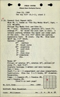
Mine Index Number: 0065
| Company Name: | Chicago and Big Muddy Coal and Coke Company | ||
|---|---|---|---|
| Mine Name: | Big Muddy No. 1 Mine | ||
| Start Date: | 1900 | End Date: | March 1925 |
| Type of Mine: | Underground | ||
| Total acres shown: | 565 The area shown designates more than the area mined prior to the company map, since the outline on the incomplete secondary source map is undated. Production from this mine indicates that the mine should be about 650 acres. Some of this area may have been surface-mined at a later date. | ||
| Acres after map date: | General Area of mining acres shown: | ||
Shaft, Slope, Drift or Tipple Location(s)
| Type | County | Township-Range | Section | Part Section |
|---|
| Main shaft (9 x 13 ft) | Williamson | 9S 2E | 2 | SE NW NW |
| Air shaft | Williamson | 9S 2E | 2 | SE NW NW |
Geology
| Thickness (ft) | |||||
|---|---|---|---|---|---|
| Seam | Depth (ft) | Min | Max | Ave | Mining Method |
| Herrin | 103 | 7.0 | 10.0 | 8.0 | RP |
Geological Problems Reported
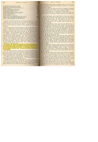
Two faults were shown on the company map, as was an area with sandstone roof. The sandstone roof was designated where mining did not occur, which indicates that the problems associated with this feature prevented economic mining. The roof material was generally 30 feet of massive gray shale, with 2 feet of sandstone below it noted at one location. This necessitated leaving 0.5 to 2 feet of top coal to support the roof, so that commonly only 7.5 feet of coal was mined. Pyrite bands of 0.5 to 0.75 inch thickness were noted in the samples taken.
Production
| Company | Mine Name | Date | Production (tons) |
| Chicago and Big Muddy Coal and Coke Company | Big Muddy No. 1 | 1900-1908 | 1,002,692 |
| Chicago and Big Muddy Coal and Coke Company | Big Muddy No. 1 | 1908-1925 | 3,634,203 Production after map date |
| Total Production: 4,636,895 | |||
Production Notes
Coal Report production (if available)
Sources of Data
| Source Map | Map Date | Original Scale | Digitized Scale | Map Type |
| Company, 4103.W52 i5.1-154 | 4-1-1908 | 1:6000 | 1:6000 | Not final |
| ISGS map library, 4103.W52 i5.1-143 | 8-4-1932 | 1:2400 | 1:2400 | Secondary source |
Annotated Bibliography (Data source - brief description of information)
| Coal Reports - Production, ownership, years of operation. |
| Directory of Illinois Coal Mines (Williamson County) - Mine names, mine index, ownership, years of operation. |
| Mine notes (Williamson County) - Mine type, shaft location, seam, depth, thickness, geological problems. |
| Company map, ISGS Map Library, 4103.W52. i5.1-154 - Shaft locations, mine outline, mining method, geologic problems. |
| ISGS map library, 4103.W52 i5.1-143, map of Peabody No. 3 Mine (mine index 60) - Mine outline (east & north). |
Mine Notes
Mine Images


Photographs