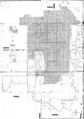
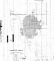
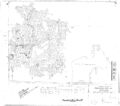
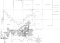
Johnston City Quadrangle
Mining in the Johnston City Quadrangle
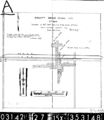
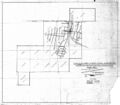
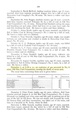
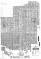
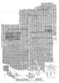
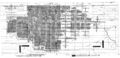
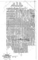
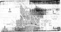
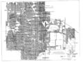
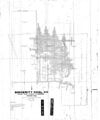
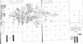
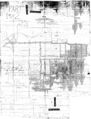
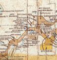
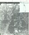
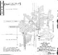
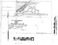
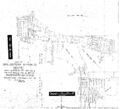
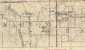
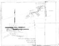
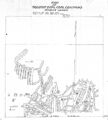
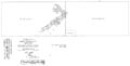
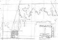
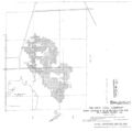
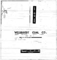
Two minable coal seams crop out in the Johnston City Quadrangle: the Herrin and Springfield Coals. Because both coals are close to the surface, both were surface mined as well as underground mined. The Herrin Coal is quite thick in this area, in some rare cases up to 14 feet, but more commonly 8 to 10 feet. The roof was typically the Energy Shale, 40 feet or more thick. This massive, sandy shale created roof problems for many mines. Top coal was often left to help support the roof, although that was sometimes mined on retreat from the rooms. The Cottage Grove Fault System and the White Ash Fault Zone both had an impact on mining in the quadrangle, but as the accompanying map shows, these faults did not prevent mining. Various geologic problems such as coal balls, rolls, and slips in the seam caused problems, but few prevented mining.
Map and Directory PDF Download
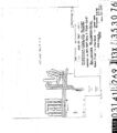
Coal Mines In Illinois Johnston City Quadrangle
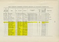
Mines that Appear on the Johnston City Quadrangle
Unlocated Mines
Williamson County
Franklin County
Pages in category "Johnston City Quadrangle"
The following 200 pages are in this category, out of 316 total.
(previous page) (next page)0
1
- 1019
- 1034
- 199002a
- 199002b
- 199004
- 199006
- 199006b
- 199011a
- 199011b
- 199019a
- 199019b
- 199020
- 199021
- 199022
- 199023
- 199024a
- 199024b
- 199025
- 199026
- 199030
- 199037
- 199039
- 199040
- 199045
- 199048
- 199049a
- 199049b
- 199049c
- 199059
- 199061
- 199065
- 199066
- 199076
- 199078
- 199082
- 199083
- 199086
- 199087a
- 199087b
- 199088
- 199089
- 199091
- 199096
- 199097
- 199098b
- 199098c
- 199099
- 199102
- 199104
- 199105
- 199107
- 199108
- 199113
- 199115
- 199119
- 199121
- 199122
- 199123
- 199126a
- 199126b
- 199127
- 199128
- 199129
- 199130
- 199131
- 199133
- 199135
- 199136
- 199137
- 199138
- 199141
- 199142
- 199144a
- 199146
- 199147
- 199148
- 199149
- 199152
- 199154
- 199158a
- 199158b
- 199160
- 199161
- 199163
- 199166
- 199168
- 199169
- 199170
- 199171
- 199172
- 199173
- 199175
- 199177
- 199179a
- 199179b
- 199180
- 199182b
- 199186
- 199192
- 199193
- 199194
- 199195
- 199196
- 199198
- 199199
- 199203
- 199205a
- 199205b
- 199210
- 199211
- 199212
- 199213
- 199214
- 199215
- 199216
- 199219
- 199220
- 199223
- 199224
- 199225
- 199226
- 199229
- 199232
- 199234
- 199235
- 199238
- 199239
- 199241
- 199243
- 199244
- 199246
- 199248
- 199249
- 199251
- 199252
- 199254
- 199255
- 199257
- 199258
- 199259
- 199262
- 199264
- 199265
- 1992763
- 1994115
- 1994265a
- 1994265b
Media in category "Johnston City Quadrangle"
The following 200 files are in this category, out of 247 total.
(previous page) (next page)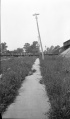 M-825 Coop 17 fig 26 broken sidewalk tilted pole Old Ben 8 - 8ft coal at 450ft.jpg 2,544 × 4,340; 1.07 MB
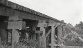 M-992 Coop 17 Fig 40 trestle 1.5ft submine.jpg 2,500 × 1,460; 366 KB
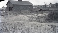 M-993 Old Ben 8 mine W Frankfort rt end 4ft lower.jpg 2,500 × 1,440; 509 KB
 M-994 Old Ben 8 mine W Frankfort Coop 17 Fig 47 rt end 4ft lower.jpg 2,500 × 1,397; 379 KB
 M0059 fieldnotes.pdf 752 × 1,195, 2 pages; 282 KB
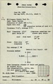
 M0059 minenotes.pdf 731 × 1,162, 18 pages; 5.79 MB
 M0060 coalreport1901 p260.pdf 1,316 × 1,156; 355 KB
 M0060 fieldnotes.pdf 758 × 1,204; 184 KB
 M0060 minenotes.pdf 727 × 1,166, 10 pages; 2.02 MB
 M0061 fieldnotes.pdf 750 × 1,193, 2 pages; 265 KB
 M0061 minenotes.pdf 731 × 1,162, 21 pages; 3.56 MB
 M0061.jpg 2,391 × 3,390; 2.75 MB
 M0061a.jpg 2,844 × 3,279; 963 KB
 M0065 coalreport1901 p260.pdf 1,316 × 1,156; 353 KB
 M0065 fieldnotes.pdf 747 × 1,197, 3 pages; 396 KB
 M0065 minenotes.pdf 727 × 1,166, 10 pages; 2.33 MB
 M0065.jpg 3,390 × 2,958; 3.52 MB
 M0143 coalreport 1910.pdf 583 × 943, 2 pages; 194 KB
 M0143 coalreport 1921.pdf 847 × 1,310; 1.65 MB
 M0143 coalreport 1924.pdf 635 × 997; 69 KB
 M0143 coalreport 1947.pdf 1,270 × 902, 2 pages; 415 KB
 M0143 coalreport1929 p190.pdf 639 × 1,000; 985 KB
 M0143 minenotes.pdf 733 × 1,202, 22 pages; 5.95 MB
 M0143.jpg 2,374 × 3,390; 4.45 MB
 M0143a.jpg 2,405 × 3,390; 4.25 MB
 M0148 coalreport1906 p353.pdf 1,675 × 1,256; 377 KB
 M0148 coalreport1914 p258.pdf 1,754 × 1,327; 311 KB
 M0148 minenotes.pdf 739 × 1,160, 20 pages; 3.61 MB
 M0148.jpg 2,485 × 3,390; 2.34 MB
 M0149 coalreport1908 p371.pdf 629 × 970; 120 KB
 M0149 coalreport1909 p408.pdf 1,606 × 1,241; 367 KB
 M0149 minenotes.pdf 739 × 1,160, 14 pages; 2.55 MB
 M0149.jpg 3,390 × 1,651; 1.39 MB
 M0150 minenotes.pdf 733 × 1,162, 14 pages; 6.57 MB
 M0151 minenotes.pdf 733 × 1,162, 13 pages; 2.6 MB
 M0154 coalreport1917 p275.pdf 602 × 991; 104 KB
 M0154 coalreport1918 p273.pdf 883 × 1,295; 194 KB
 M0154 minenotes.pdf 737 × 1,160, 24 pages; 4.33 MB
 M0154.jpg 2,167 × 3,390; 3.12 MB
 M0155 minenotes.pdf 737 × 1,160, 27 pages; 6.03 MB
 M0155comp.jpg 3,390 × 1,820; 2.75 MB
 M0156 coalreport1906 p355.pdf 1,683 × 1,285; 453 KB
 M0156 coalreport1907 p350.pdf 587 × 966; 111 KB
 M0156 fieldnotes.pdf 747 × 1,193; 195 KB
 M0156 minenotes.pdf 737 × 1,160, 23 pages; 4.36 MB
 M0157 coalreport1901 p260.pdf 1,316 × 1,156; 353 KB
 M0157 fieldnotes.pdf 750 × 1,197, 2 pages; 246 KB
 M0157 minenotes.pdf 731 × 1,162, 17 pages; 3.22 MB
 M0157mrg.jpg 3,390 × 2,554; 2.11 MB
 M0160 minenotes.pdf 731 × 1,162, 26 pages; 11.97 MB
 M0160.jpg 2,831 × 3,390; 1.5 MB
 M0169 coalreport1906 p353.pdf 1,675 × 1,256, 2 pages; 817 KB
 M0169 minenotes.pdf 727 × 1,166, 27 pages; 8.31 MB
 M0170 minenotes.pdf 727 × 1,166, 5 pages; 1,013 KB
 M0171 minenotes.pdf 727 × 1,166, 15 pages; 3.14 MB
 M0172 MOA1959 Area 30.jpg 1,412 × 645; 241 KB
 M0173 fieldnotes.pdf 766 × 1,202; 257 KB
 M0173 minenotes.pdf 725 × 1,160, 20 pages; 3.67 MB
 M0321 coalreport1908 p372.pdf 629 × 970; 107 KB
 M0321 coalreport1917 p275.pdf 602 × 991; 96 KB
 M0321 minenotes.pdf 733 × 1,162, 10 pages; 1.88 MB
 M0322 10-11-03.jpg 3,390 × 2,948; 2.39 MB
 M0322 fieldnotes.pdf 752 × 1,197, 2 pages; 308 KB
 M0322 minenotes.pdf 731 × 1,162, 10 pages; 1.92 MB
 M0323 minenotes.pdf 731 × 1,162, 6 pages; 1.03 MB
 M0421 coalreport 1908p348.pdf 629 × 970; 70 KB
 M0421 coalreport 1909p370.pdf 1,591 × 1,229; 394 KB
 M0421 fieldnotes.pdf 752 × 1,200, 8 pages; 745 KB
 M0421 minenotes.pdf 733 × 1,202, 27 pages; 7.03 MB
 M0428 minenotes.pdf 733 × 1,202, 16 pages; 3.91 MB
 M0448 coalreport 1913p246.pdf 793 × 1,187; 1.46 MB
 M0448 minenotes.pdf 733 × 1,202, 19 pages; 5.39 MB
 M0449 coalreport1909 p407.pdf 1,606 × 1,241; 338 KB
 M0449 minenotes.pdf 722 × 1,166, 15 pages; 3.68 MB
 M0454 coalreport1897 p141.pdf 839 × 1,185; 96 KB
 M0454 coalreport1898 p220.pdf 1,585 × 1,168; 315 KB
 M0454 fieldnotes.pdf 747 × 1,195; 167 KB
 M0454 minenotes.pdf 731 × 1,162, 10 pages; 1.99 MB
 M0506 minenotes.pdf 733 × 1,162, 10 pages; 1.8 MB
 M0506a.jpg 3,151 × 1,693; 785 KB
 M0662 minenotes.pdf 731 × 1,162, 147 pages; 28.89 MB
 M0688 minenotes.pdf 739 × 1,160, 109 pages; 28.04 MB
 M0689 minenotes.pdf 737 × 1,160, 3 pages; 623 KB
 M0689.jpg 3,390 × 2,680; 4.77 MB
 M0711 minenotes.pdf 731 × 1,162, 5 pages; 927 KB
 M0815 fieldnotes.pdf 747 × 1,197, 4 pages; 562 KB
 M0815 minenotes.pdf 731 × 1,162, 4 pages; 692 KB
 M0816 coalreport1907 p350.pdf 587 × 966; 130 KB
 M0816 minenotes.pdf 733 × 1,162, 23 pages; 3.99 MB
 M0818 minenotes.pdf 727 × 1,166, 15 pages; 3.14 MB
 M0823 fieldnotes.pdf 756 × 1,202, 2 pages; 270 KB
 M0823 minenotes.pdf 731 × 1,162, 7 pages; 1.25 MB
 M0823mrg.jpg 2,587 × 3,390; 1.79 MB
 M0882 minenotes.pdf 756 × 1,210, 15 pages; 3.27 MB
 M0941 minenotes.pdf 727 × 1,166, 3 pages; 527 KB
 M0944 minenotes.pdf 727 × 1,166, 38 pages; 8.33 MB
 M0950 minenotes.pdf 727 × 1,166, 15 pages; 3.66 MB
 M0970 minenotes.pdf 727 × 1,166, 5 pages; 913 KB
 M0971 minenotes.pdf 727 × 1,166, 31 pages; 7.19 MB
 M0972 minenotes.pdf 731 × 1,162, 9 pages; 1.84 MB
 M0976 minenotes.pdf 727 × 1,166, 13 pages; 3.51 MB
 M0977.jpg 289 × 302; 106 KB
 M0978 minenotes.pdf 731 × 1,162, 4 pages; 460 KB
 M0979 minenotes.pdf 727 × 1,166, 32 pages; 7.4 MB
 M1019 minenotes.pdf 695 × 1,189, 3 pages; 579 KB
 M1019.jpg 2,495 × 3,390; 3.7 MB
 M1034.jpg 2,841 × 3,390; 3.27 MB
 M199025 coalreport1896 p167.pdf 1,616 × 1,208; 291 KB
 M199025 coalreport1897 p141.pdf 839 × 1,185; 88 KB
 M199025 coalreport1898 p220.pdf 1,585 × 1,168; 314 KB
 M2763 minenotes.pdf 727 × 1,166, 5 pages; 925 KB
 M2764 minenotes.pdf 727 × 1,166, 4 pages; 740 KB
 M3665 fieldnotes.pdf 752 × 1,195; 167 KB
 M3973 minenotes.pdf 731 × 1,162, 4 pages; 667 KB
 M3974 minenotes.pdf 731 × 1,162, 7 pages; 971 KB
 M3975 minenotes.pdf 731 × 1,162, 4 pages; 718 KB
 M3976 minenotes.pdf 731 × 1,162, 6 pages; 1.17 MB
 M3976a.jpg 3,007 × 3,390; 1.95 MB
 M3977 minenotes.pdf 731 × 1,162, 4 pages; 703 KB
 M3977a.jpg 2,681 × 3,390; 1.11 MB
 M3977b.jpg 3,390 × 2,717; 1.69 MB
 M3978 minenotes.pdf 731 × 1,162, 14 pages; 2.39 MB
 M3979 minenotes.pdf 731 × 1,162, 4 pages; 684 KB
 M3980 minenotes.pdf 731 × 1,162; 96 KB
 M4009 minenotes.pdf 727 × 1,166, 6 pages; 1.57 MB
 M4010 353272.jpg 3,029 × 2,852; 1.24 MB
 M4011 353154.jpg 3,264 × 2,504; 923 KB
 M4011 minenotes.pdf 727 × 1,166, 7 pages; 1.18 MB
 M4012 fieldnotes.pdf 747 × 1,195; 172 KB
 M4012 minenotes.pdf 727 × 1,166, 7 pages; 1.22 MB
 M4013 fieldnotes.pdf 747 × 1,195; 171 KB
 M4013 minenotes.pdf 727 × 1,166, 3 pages; 532 KB
 M4014 minenotes.pdf 727 × 1,166, 3 pages; 538 KB
 M4014.jpg 3,390 × 2,687; 751 KB
 M4015 minenotes.pdf 727 × 1,166, 3 pages; 519 KB
 M4016 minenotes.pdf 727 × 1,166, 5 pages; 1.1 MB
 M4016.jpg 3,330 × 3,036; 1.68 MB
 M4017 minenotes.pdf 727 × 1,166, 3 pages; 566 KB
 M4019 minenotes.pdf 727 × 1,166, 7 pages; 1.44 MB
 M4020 fieldnotes.pdf 768 × 1,195; 193 KB
 M4020 minenotes.pdf 727 × 1,166, 5 pages; 1.01 MB
 M4021 minenotes.pdf 727 × 1,166, 3 pages; 580 KB
 M4022 minenotes.pdf 727 × 1,166, 4 pages; 778 KB
 M4024 fieldnotes.pdf 747 × 1,195; 145 KB
 M4024 minenotes.pdf 727 × 1,166, 3 pages; 553 KB
 M4025 minenotes.pdf 727 × 1,166, 2 pages; 274 KB
 M4026 minenotes.pdf 756 × 1,210, 3 pages; 1.06 MB
 M4028 coalreport1897 p142.pdf 839 × 1,185; 165 KB
 M4028 coalreport1898 p220.pdf 1,585 × 1,168; 321 KB
 M4028 minenotes.pdf 727 × 1,166, 3 pages; 539 KB
 M4030 minenotes.pdf 727 × 1,166, 3 pages; 548 KB
 M4030.jpg 2,870 × 3,390; 586 KB
 M4031 minenotes.pdf 727 × 1,166, 3 pages; 562 KB
 M4032 minenotes.pdf 727 × 1,166, 5 pages; 965 KB
 M4033 minenotes.pdf 727 × 1,166, 3 pages; 531 KB
 M4036 minenotes.pdf 727 × 1,166, 3 pages; 551 KB
 M4036.jpg 495 × 291; 108 KB
 M4037 minenotes.pdf 727 × 1,166, 9 pages; 3.34 MB
 M4037.jpg 3,390 × 2,642; 1.36 MB
 M4038 minenotes.pdf 727 × 1,166, 3 pages; 524 KB
 M4038.jpg 3,062 × 3,390; 2.07 MB
 M4039 minenotes.pdf 727 × 1,166, 7 pages; 1.52 MB
 M4039.jpg 3,390 × 2,996; 1.31 MB
 M4041 minenotes.pdf 758 × 1,210, 4 pages; 1.81 MB
 M4042 minenotes.pdf 727 × 1,166, 4 pages; 859 KB
 M4042.jpg 3,390 × 2,461; 1.05 MB
 M4043 minenotes.pdf 727 × 1,166, 3 pages; 596 KB
 M4044 minenotes.pdf 727 × 1,166, 3 pages; 566 KB
 M4044.jpg 3,390 × 1,721; 377 KB
 M4045 minenotes.pdf 727 × 1,166, 5 pages; 982 KB
 M4045.jpg 3,318 × 3,390; 1.68 MB
 M4046 minenotes.pdf 727 × 1,166, 4 pages; 783 KB
 M4047 minenotes.pdf 727 × 1,166, 2 pages; 279 KB
 M4048 minenotes.pdf 727 × 1,166, 2 pages; 294 KB
 M4049 minenotes.pdf 727 × 1,166, 3 pages; 494 KB
 M4049a.jpg 3,390 × 2,635; 1.26 MB
 M4050 minenotes.pdf 727 × 1,166, 4 pages; 835 KB
 M4051 minenotes.pdf 727 × 1,166, 4 pages; 865 KB
 M4051.jpg 3,390 × 3,139; 1.76 MB
 M4052 minenotes.pdf 727 × 1,166, 3 pages; 561 KB
 M4052.jpg 3,390 × 2,379; 1,022 KB
 M4053 minenotes.pdf 727 × 1,166, 2 pages; 447 KB
 M4054 minenotes.pdf 727 × 1,166, 3 pages; 694 KB
 M4054.jpg 3,390 × 3,349; 1.06 MB
 M4055 minenotes.pdf 725 × 1,160, 4 pages; 685 KB
 M4056 minenotes.pdf 725 × 1,160, 3 pages; 521 KB
 M4056.jpg 2,992 × 3,390; 842 KB
 M4057 minenotes.pdf 725 × 1,160, 2 pages; 257 KB
 M4057.jpg 3,227 × 3,390; 923 KB
 M4058 fieldnotes.pdf 754 × 1,191; 127 KB
 M4058 minenotes.pdf 725 × 1,160, 3 pages; 474 KB
 M4059 minenotes.pdf 725 × 1,160, 3 pages; 502 KB
 M4059.jpg 3,390 × 2,387; 1.47 MB
 M4060 minenotes.pdf 725 × 1,160, 3 pages; 496 KB
 M4060.jpg 3,390 × 2,906; 2.34 MB
 M4061 minenotes.pdf 725 × 1,160, 6 pages; 1.08 MB
 M4062 minenotes.pdf 725 × 1,160, 6 pages; 1.16 MB
 M4181 fieldnotes.pdf 750 × 1,195; 175 KB
 M4262 fieldnotes.pdf 756 × 1,200; 187 KB
 M4262 minenotes.pdf 756 × 1,210, 4 pages; 1.66 MB


