Mine Index Number: 0156
| Company Name:
|
Chicago, Wilmington and Franklin Mining Company
|
| Mine Name:
|
B Mine
|
| Start Date:
|
1906
|
End Date:
|
April 1923
|
| Type of Mine:
|
Underground
|
| Total acres shown:
|
397
|
| Acres after map date:
|
10
|
General Area of mining acres shown:
|
|
|
|
Shaft, Slope, Drift or Tipple Location(s)
| Type
|
County
|
Township-Range
|
Section
|
Part Section
|
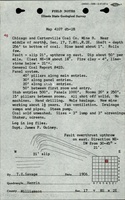
| Main shaft
|
Williamson
|
8S 2E
|
17
|
SW NW NE
|
| Air shaft
|
Williamson
|
8S 2E
|
17
|
SW NW NE
|
| Shaft (possible)
|
Williamson
|
8S 2E
|
8
|
NE SE SW The source map is not very clear; there is a definite mark on the source map at this location and a configuration of entries that could very well indicate a shaft at this location.
|
Geology
| Herrin
|
241-248
|
7.0
|
11.0
|
9.0-10.0
|
RPP
|
Geological Problems Reported
A gas explosion killed one man in 1911. A V-shaped block fault trending northwestsoutheast was downthrown 3 feet on the western side. The coal and roof shale were shattered near the fault. Another fault was noted 200 feet north of the shaft with the southwestern side upthrown 21 feet. The roof was “white top”, a light gray sandy shale that was soft, massive, and did not hold up well. Two feet of top coal was left to support the roof and timbering was also necessary. Rolls and faults were present in the mine. One roll was noted 1000 feet east of the bottom of the shaft. Pyrite stringers were present in the center of the seam in the northeast portion of the mine. The mine had very little water, and the underclay heaved very little.
Production
| Company
|
Mine Name
|
Date
|
Production (tons)
|
|
|
|
|
|
| Total Production: 3,015,509
|
Production Notes
Coal Report production (if available)
Sources of Data
| Company, 4103.W52 i5.1-12
|
1-1-1923
|
1:2400
|
1:4950
|
Not final
|
Annotated Bibliography (Data source - brief description of information)
| Coal Reports - Production, ownership, years of operation, geologic problems.
|
| Directory of Illinois Coal Mines (Williamson County) - Mine names, mine index, ownership, years of operation.
|
| Mine notes (Williamson County) - Mine type, shaft location, seam, depth, thickness, geologic problems.
|
| Company map, ISGS map library, 4103.W52 i5.1-12 - Shaft locations, mine outline, mining method.
|
Mine Notes
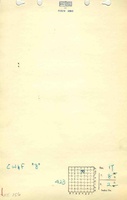
Mine Images
![[[:B|B]]](https://wikiimage.isgs.illinois.edu/ilmines/williamson/thumbnails/m0156mrg_th.jpg) These files may not be true to scale and are not georgistered. These files may not be true to scale and are not georgistered.
|
Map Type:
|
Company
|
| Map ID:
|
4103.w52 i5.1-12
|
| Company:
|
Chicago, Wilmington and Franklin Mining Company
|
| Mine Name:
|
B
|
| Caption:
|
|
| Map Date:
|
1-1-1923
|
| Map Status:
|
Not Final
|
| Image Credit:
|
|
| Note:
|
|
| More Info:
|
M0156mrg.jpg
|
| Full Res Download:These files are true to scale and most are georegistered for gis software. These files may be a very large (>1GB) download!
|
https://wikiimage.isgs.illinois.edu/ilmines/williamson/m0156mrg.zip
|
Photographs