Mine Index Number: 0155
| Company Name:
|
Old Ben Coal Corporation
|
| Mine Name:
|
Old Ben No. 18 Mine
|
| Start Date:
|
1917
|
End Date:
|
December 1935
|
| Type of Mine:
|
Underground
|
| Total acres shown:
|
940
|
| Acres after map date:
|
|
General Area of mining acres shown:
|
|
|
|
Shaft, Slope, Drift or Tipple Location(s)
| Type
|
County
|
Township-Range
|
Section
|
Part Section
|
| Main shaft
|
Williamson
|
8S 2E
|
12
|
SE SE SW
|
| Air / escape shaft
|
Williamson
|
8S 2E
|
12
|
NE SE SW
|
Geology
| Herrin
|
261-270
|
7.0
|
11.0
|
9.0-10.0
|
RPP,HERsome HER
|
Geological Problems Reported
The mine map shows faults cutting through the northern half of the mine. A fault was noted 4000 feet from the bottom of the shaft; its displacement was from 3 to 32 feet, upthrown on the eastern side. The coal was shattered near the fault and many slips parallel to the fault were present. The light gray sandy shale roof (up to 40 feet thick) was full of slips and tended to come down without warning. Generally the roof held better in the east-west entries than in the north-south entries. Top coal was left to support the roof where possible, but sometimes the coal was too thin and did not provide adequate support. The coal bed had swags, and in one case the coal dropped 6 feet for a distance of 300 feet but remained full thickness. Pyrite and calcite stringers were present in fractures and as fillings throughout the mine and the full thickness of the coal. The floor clay varied from 6 inches to 4 feet thick, and heaved when wet. In some places, however, the underclay was a dark gray fireclay that made excellent floor.
Production
| Company
|
Mine Name
|
Date
|
Production (tons)
|
|
|
|
|
|
| Total Production: 7,620,647
|
Production Notes
Coal Report production (if available)
Sources of Data
| Company, Old Ben Archive Collection
|
7-1-1936
|
1:2400
|
1:2400
|
Final
|
| Microfilm, document 353105
|
12-31-1935
|
1:2400
|
1:5628
|
Final
|
| Microfilm, document 353106
|
7-5-1935
|
1:2400
|
1:5628
|
Not final
|
Annotated Bibliography (Data source - brief description of information)
| Coal Reports - Production, ownership, years of operation.
|
| Directory of Illinois Coal Mines (Williamson County) - Mine names, mine index, ownership, years of operation.
|
| Mine notes (Williamson County) - Mine type, shaft locations, seam, depth, thickness, geologic problems.
|
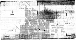
| Company map, Old Ben Coal Company Archive Collection - Mine outline (south), shaft locations, mining method, geologic problems.
|
| Microfilm map, document 353105, reel 03141, frames 318, 320, 321 - Shaft locations, mine outline (north), mining method, geologic problems.
|
| Microfilm map, document 353106, reel 03141, frame 323 - Mine outline (northeast).
|
Mine Notes
Mine Images
Microfilm: 353105
Map Date: 12-31-1935
Coal Co.: Old Ben Coal Corporation
Mine Name: Old Ben No. 18 Mine
Full Res Download
![[[:Old Ben No. 17|Old Ben No. 17]]](https://wikiimage.isgs.illinois.edu/ilmines/williamson/thumbnails/m0059mrg.jpg) These files may not be true to scale and are not georgistered. These files may not be true to scale and are not georgistered.
|
Map Type:
|
Company
|
| Map ID:
|
Old Ben Archive Collection
|
| Company:
|
Old Ben Coal Corporation
|
| Mine Name:
|
Old Ben No. 17
|
| Caption:
|
|
| Map Date:
|
07/01/1936
|
| Map Status:
|
Final
|
| Image Credit:
|
|
| Note:
|
|
| More Info:
|
M0059mrg.tif
|
| Full Res Download:These files are true to scale and most are georegistered for gis software. These files may be a very large (>1GB) download!
|
https://wikiimage.isgs.illinois.edu/ilmines/williamson/m0059mrg.zip
|
Photographs


![[[:Old Ben No. 17|Old Ben No. 17]]](https://wikiimage.isgs.illinois.edu/ilmines/williamson/thumbnails/m0059mrg.jpg)