Mine Index Number: 0421
| Company Name:
|
Franklin County Coal Corporation
|
| Mine Name:
|
Energy No. 5 Mine
|
| Start Date:
|
1909
|
End Date:
|
April 1950
|
| Type of Mine:
|
Underground
|
| Total acres shown:
|
2,669
|
| Acres after map date:
|
|
General Area of mining acres shown:
|
|
|
|
Shaft, Slope, Drift or Tipple Location(s)
| Type
|
County
|
Township-Range
|
Section
|
Part Section
|
| Main shaft (9.5 x 16 ft)
|
Franklin
|
7S 2E
|
33
|
NW SW SW
|
| Air Shaft
|
Franklin
|
7S 2E
|
32
|
610 FSL, 360 FEL
|
Geology
Geological Problems Reported
Gas may have been a problem; one man was killed by an explosion. The roof was a gray sandy shale that was soft and full of slips. Top coal was generally left to protect and support the roof; this top coal was recovered on retreat. The seam was very hilly. Grades of 8% were common. A northwest-southeast trending cutout was present at the shaft bottom. A fault with 27 feet of throw and a 10 foot gouge zone was present. There were very few impurities in the seam, only a few faces of calcite were observed. The underclay did not heave much.
Production
| Company
|
Mine Name
|
Date
|
Production (tons)
|
|
|
|
|
|
| Total Production: 19,478,803
|
Production Notes
Coal Report production (if available)
Sources of Data
| Microfilm, document 351445
|
4-15-1950
|
1:6000
|
1:14068
|
Final
|
Annotated Bibliography (Data source - brief description of information)
| Coal Reports - Production, ownership, years of operation, shaft size, thickness, geologic problems.
|
| Directory of Illinois Coal Mines (Franklin County) - Mine names, mine index, ownership, years of operation.
|
| Mine notes (Franklin County) - Mine type, shaft locations, seam, depth, thickness, geologic problems.
|
| Microfilm map, document 351445, reel 03136, frames 124-128 - Shaft locations, mine outline, mining method.
|
| Company map, ISGS map library, 4102 i5.1-3 - Shaft locations (used to locate air shaft on microfilm).
|
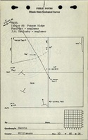
Mine Notes
Mine Images
![[[:Taylor No. 5|Taylor No. 5]]](https://wikiimage.isgs.illinois.edu/ilmines/williamson/thumbnails/m0421_th.jpg) These files may not be true to scale and are not georgistered. These files may not be true to scale and are not georgistered.
|
Map Type:
|
Microfilm
|
| Map ID:
|
351445 03136 124-128,34x
|
| Company:
|
Taylor Coal Corporation
|
| Mine Name:
|
Taylor No. 5
|
| Caption:
|
|
| Map Date:
|
4-15-1950
|
| Map Status:
|
Final
|
| Image Credit:
|
|
| Note:
|
|
| More Info:
|
M0421.jpg
|
| Full Res Download:These files are true to scale and most are georegistered for gis software. These files may be a very large (>1GB) download!
|
https://wikiimage.isgs.illinois.edu/ilmines/williamson/m0421.zip
|
Photographs