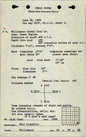
Mine Index Number: 0823
| Company Name:
|
St. Louis Coal and Iron Company
|
| Mine Name:
|
Black Briar No. 1 Mine
|
| Start Date:
|
1896
|
End Date:
|
April 1924
|
| Type of Mine:
|
Underground
|
| Total acres shown:
|
612
|
| Acres after map date:
|
|
General Area of mining acres shown:
|
|
|
|
Shaft, Slope, Drift or Tipple Location(s)
| Type
|
County
|
Township-Range
|
Section
|
Part Section
|
| Main shaft
|
Williamson
|
8S 2E
|
24
|
SE SE SE
|
| Air shaft
|
Williamson
|
8S 2E
|
24
|
SE SE SE
|
Geology
| Herrin
|
172 (air shaft 190)
|
7.0
|
12.0
|
9.33
|
RPP
|
Geological Problems Reported
An explosion of “fire damp” (methane) killed four men in 1897.
Production
| Company
|
Mine Name
|
Date
|
Production (tons)
|
|
|
|
|
|
| Total Production: 4,496,848
|
Production Notes
Coal Report production (if available)
Sources of Data
| Microfilm, document 353091
|
5-1924
|
1:2400
|
1:4303
|
Not final
|
| ISGS map library, 4103.W52 i5.1-137
|
3-23-1929
|
1:2400
|
1:2400
|
Secondary source The mined area shown on the accompanying map is the approximate size expected for the production reported. This suggests that the mine outline is complete.
|
| Microfilm, document 353175
|
7-1-1931
|
1:2400
|
1:4469
|
Secondary source The mined area shown on the accompanying map is the approximate size expected for the production reported. This suggests that the mine outline is complete.
|
Annotated Bibliography (Data source - brief description of information)
| Coal Reports - Production, ownership, years of operation.
|
| Directory of Illinois Coal Mines (Williamson County) - Mine names, mine index, ownership, years of operation.
|
| Mine notes (Williamson County) - Mine type, shaft locations, seam, depth, thickness, geologic problems.
|
| Microfilm map, document 353091, reel 03141, frames 291-292 - Shaft locations, mine outline, mining method.
|
| ISGS map library, 4103.W52 i5.1-137, map of Peabody No. 26 Mine (mine index 157) - Mine outline (western).
|
| Microfilm map, document 353175, reel 3142, frames 65 and 66, map of Black Briar No. 2 Mine (mine index 506) - Mine outline (eastern).
|
Mine Notes
Mine Images
ISGS map library: 4103.W52 i5.1-137
Map Date: 3-23-1929
Coal Co.: Peabody Coal Company
Mine Name: Peabody No. 26 Mine
Full Res Download
Microfilm: 353175
Map Date: 7-1-1931
Coal Co.: St. Louis Coal and Iron Company
Mine Name: Black Briar No. 2 Mine
Full Res Download
Microfilm: 353091
Map Date: 5-1924
Coal Co.: St. Louis Coal and Iron Company
Mine Name: Black Briar No. 1 Mine
Full Res Download
Photographs