Category:Williamsville-Quadrangle: Difference between revisions
Alan.Myers (talk | contribs) No edit summary |
Alan.Myers (talk | contribs) No edit summary |
||
| (One intermediate revision by the same user not shown) | |||
| Line 1: | Line 1: | ||
__NOTOC__ | __NOTOC__ | ||
==Mining in the Williamsville Quadrangle== | |||
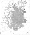
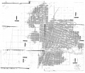
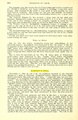
Mining began in the Williamsville Quadrangle prior to 1882 with the Barclay Coal and Mining Company. In | |||
1893, Williamsville Coal Company opened a mine about halfway between Sherman and Williamsville. | |||
Both of these mines had closed by the time the Howard Brothers opened their mine in 1926. The Howard | |||
Brothers Mine later became Wenneborg No. 2, and was the last mine operating in this quadrangle. | |||
Peabody Coal Company operated two mines in the Williamsville Quadrangle; No. 52 Mine, which | |||
consisted of an entry extending northward from the Springfield East Quadrangle, and No. 6 Mine, which | |||
began mining in this quadrangle in 1904. | |||
Mining began in the Williamsville Quadrangle prior to 1882 with the Barclay Coal and Mining Company. In 1893, Williamsville Coal Company opened a mine about halfway between Sherman and Williamsville. Both of these mines had closed by the time the Howard Brothers opened their mine in 1926. The Howard Brothers Mine later became Wenneborg No. 2, and was the last mine operating in this quadrangle. Peabody Coal Company operated two mines in the Williamsville Quadrangle; No. 52 Mine, which consisted of an entry extending northward from the Springfield East Quadrangle, and No. 6 Mine, which began mining in this quadrangle in 1904. | |||
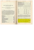
Records of annual production were not officially kept until 1881 when the first Illinois Bureau of Labor Statistics Biennial Reports was published. Sangamon County ranked among the top four coal producers in the state until the 1930s, but production gradually fell off and by 1953 the overall rank was 9th. | Records of annual production were not officially kept until 1881 when the first Illinois Bureau of Labor | ||
Statistics Biennial Reports was published. Sangamon County ranked among the top four coal producers | |||
in the state until the 1930s, but production gradually fell off and by 1953 the overall rank was 9th. | |||
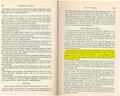
The Springfield Coal, formerly known as the No. 5 Coal, is the major seam mined in this quadrangle. The coal is 200 to 270 feet deep and ranges from 5.5 to 6.0 feet thick. Clay veins, also called horsebacks, were present in the mines of the Williamsville Quadrangle, but were not noted for causing problems in controlling the mine roof in this area. The roof contained a large number of concretions in some localities, and one mine reported problems with the thick clay floor. | The Springfield Coal, formerly known as the No. 5 Coal, is the major seam mined in this quadrangle. The | ||
coal is 200 to 270 feet deep and ranges from 5.5 to 6.0 feet thick. Clay veins, also called horsebacks, | |||
were present in the mines of the Williamsville Quadrangle, but were not noted for causing problems in | |||
controlling the mine roof in this area. The roof contained a large number of concretions in some localities, | |||
and one mine reported problems with the thick clay floor. | |||
==Mines that Appear on the | ==Map and Directory PDF Download== | ||
[https://wikiimage.isgs.illinois.edu/ilmines/webfiles/topo-mines/Williamsville.pdf Coal Mines In Illinois Williamsville Quadrangle]</br> | |||
==Mines that Appear on the Williamsville Quadrangle== | |||
{{#css: | {{#css: | ||
#mw-subcategories {display: none} | #mw-subcategories {display: none} | ||
| Line 21: | Line 28: | ||
#mw-category-media {display: none} | #mw-category-media {display: none} | ||
}} | }} | ||
{{#ask:[[Category:Williamsville- | {{#ask:[[Category:Williamsville-Quadrangle]] | ||
[[:+]] | [[:+]] | ||
[[Unlocated::No]] | [[Unlocated::No]] | ||
|?combined = Coal Company, Mine Name | |?combined = Coal Company, Mine Name | ||
|?County | |?County | ||
|format= | |format=datatables|limit=1500|link=all|sort=Mine Index|order=asc|headers=plain|mainlabel=Mine Index|searchlabel=... further results|class=sortable wikitable smwtable|sep=<br>|Default='''Mines for this quadrangle have not been entered into Ilmines-Wiki see download above for more information'''}} | ||
==Unlocated Mines in Logan County== | ==Unlocated Mines== | ||
===Sangamon County=== | |||
{{#ask:[[Category:Sangamon-County]] | |||
[[:+]] | |||
[[Unlocated::Yes]] | |||
|?combined = Coal Company, Mine Name | |||
|?City | |||
|format=datatables|limit=1500|link=all|sort=Mine Index|order=asc|headers=plain|mainlabel=Mine Index|searchlabel=... further results|default=There are no known Unlocated mines in this county |class=sortable wikitable smwtable|sep=<br>}} | |||
===Logan County=== | |||
{{#ask:[[Category:Logan-County]] | {{#ask:[[Category:Logan-County]] | ||
[[:+]] | [[:+]] | ||
| Line 34: | Line 49: | ||
|?combined = Coal Company, Mine Name | |?combined = Coal Company, Mine Name | ||
|?City | |?City | ||
|format= | |format=datatables|limit=1500|link=all|sort=Mine Index|order=asc|headers=plain|mainlabel=Mine Index|searchlabel=... further results|default=There are no known Unlocated mines in this county |class=sortable wikitable smwtable|sep=<br>}} | ||
===Menard County=== | |||
== | {{#ask:[[Category:Menard-County]] | ||
{{#ask:[[Category: | |||
[[:+]] | [[:+]] | ||
[[Unlocated::Yes]] | [[Unlocated::Yes]] | ||
|?combined = Coal Company, Mine Name | |?combined = Coal Company, Mine Name | ||
|?City | |?City | ||
|format= | |format=datatables|limit=1500|link=all|sort=Mine Index|order=asc|headers=plain|mainlabel=Mine Index|searchlabel=... further results|default=There are no known Unlocated mines in this county |class=sortable wikitable smwtable|sep=<br>}} | ||
{{DISPLAYTITLE:Williamsville Quadrangle}} | |||
Latest revision as of 14:24, October 27, 2022
Mining in the Williamsville Quadrangle
Mining began in the Williamsville Quadrangle prior to 1882 with the Barclay Coal and Mining Company. In 1893, Williamsville Coal Company opened a mine about halfway between Sherman and Williamsville. Both of these mines had closed by the time the Howard Brothers opened their mine in 1926. The Howard Brothers Mine later became Wenneborg No. 2, and was the last mine operating in this quadrangle. Peabody Coal Company operated two mines in the Williamsville Quadrangle; No. 52 Mine, which consisted of an entry extending northward from the Springfield East Quadrangle, and No. 6 Mine, which began mining in this quadrangle in 1904.
Records of annual production were not officially kept until 1881 when the first Illinois Bureau of Labor Statistics Biennial Reports was published. Sangamon County ranked among the top four coal producers in the state until the 1930s, but production gradually fell off and by 1953 the overall rank was 9th.
The Springfield Coal, formerly known as the No. 5 Coal, is the major seam mined in this quadrangle. The coal is 200 to 270 feet deep and ranges from 5.5 to 6.0 feet thick. Clay veins, also called horsebacks, were present in the mines of the Williamsville Quadrangle, but were not noted for causing problems in controlling the mine roof in this area. The roof contained a large number of concretions in some localities, and one mine reported problems with the thick clay floor.
Map and Directory PDF Download
Coal Mines In Illinois Williamsville Quadrangle
Mines that Appear on the Williamsville Quadrangle
Unlocated Mines
Sangamon County
Logan County
Menard County
Pages in category "Williamsville-Quadrangle"
The following 8 pages are in this category, out of 8 total.
Media in category "Williamsville-Quadrangle"
The following 15 files are in this category, out of 15 total.
 M0036 351228.jpg 2,855 × 3,398; 2.17 MB
 M0036 fieldnotes.pdf 747 × 1,195, 2 pages; 541 KB
 M0036 minenotes.pdf 727 × 1,160, 13 pages; 1.27 MB
 M0039 351220.jpg 3,398 × 2,925; 2.09 MB
 M0039 coalreport 1903p261.pdf 1,552 × 1,239; 313 KB
 M0039 coalreport 1904.pdf 1,652 × 1,214, 2 pages; 811 KB
 M0039 coalreport 1905.pdf 633 × 977, 3 pages; 227 KB
 M0039 minenotes.pdf 727 × 1,166, 12 pages; 1.2 MB
 M0040 minenotes.pdf 727 × 1,166, 18 pages; 1.79 MB
 M0040 pb 958 03.jpg 3,398 × 2,956; 1.52 MB
 M0680 351234.jpg 2,087 × 3,398; 725 KB
 M0680 minenotes.pdf 727 × 1,166, 14 pages; 1.51 MB
 M3357 coalreport 1884.pdf 1,520 × 1,283; 365 KB
 M3357 minenotes.pdf 727 × 1,166, 8 pages; 775 KB
 M4363 minenotes.pdf 731 × 1,202, 2 pages; 325 KB


