Category:Oconee-Quadrangle: Difference between revisions
Alan.Myers (talk | contribs) (Created page with " __NOTOC__ <center> </center> ==MINING IN THE OOCONEE QUADRANGLE== Two seams were mined in the Oconee quad. The Herrin Coal was mined in the northern part of the quad by two l...") |
Alan.Myers (talk | contribs) No edit summary |
||
| (One intermediate revision by the same user not shown) | |||
| Line 1: | Line 1: | ||
__NOTOC__ | |||
==Mining in the Oconee Quadrangle== | |||
Two seams were mined in the Oconee quad. The Herrin Coal was mined in the northern part of the quad | |||
by two large mines. The first of these to open was the Penwell Mine (mine index [[0371]]) in 1888. The Herrin | |||
Coal was deep here at over 700 feet, but the coal was thick, averaging 7.5 feet thick. This mine operated | |||
until 1945. In 1949, the Peabody No. 17 Mine (mine index [[0679]]) opened. This mine was also over 700 | |||
feet deep, with a thick Herrin Coal that averaged 8 feet. It operated until 1957. | |||
The Shelbyville Coal was also mined in this quad on a much smaller scale. This coal was generally | |||
worked along or near streams, in small drift mines. These mines operated very early on. | |||
==Map and Directory PDF Download== | |||
[https://wikiimage.isgs.illinois.edu/ilmines/webfiles/topo-mines/Oconee.pdf Coal Mines In Illinois Oconee Quadrangle]</br> | |||
== | |||
==Mines that Appear on the Oconee Quadrangle== | ==Mines that Appear on the Oconee Quadrangle== | ||
| Line 13: | Line 19: | ||
#mw-category-media {display: none} | #mw-category-media {display: none} | ||
}} | }} | ||
{{#ask:[[Category:Oconee- | {{#ask:[[Category:Oconee-Quadrangle]] | ||
[[:+]] | [[:+]] | ||
[[Unlocated::No]] | [[Unlocated::No]] | ||
|?combined = Coal Company, Mine Name | |?combined = Coal Company, Mine Name | ||
|?County | |?County | ||
|format= | |format=datatables|limit=1500|link=all|sort=Mine Index|order=asc|headers=plain|mainlabel=Mine Index|searchlabel=... further results|class=sortable wikitable smwtable|sep=<br>|Default='''Mines for this quadrangle have not been entered into Ilmines-Wiki see download above for more information'''}} | ||
==Unlocated Mines | ==Unlocated Mines== | ||
{{#ask:[[Category: | ===Shelby County=== | ||
{{#ask:[[Category:Shelby-County]] | |||
[[:+]] | [[:+]] | ||
[[Unlocated::Yes]] | [[Unlocated::Yes]] | ||
|?combined = Coal Company, Mine Name | |?combined = Coal Company, Mine Name | ||
|?City | |?City | ||
|format= | |format=datatables|limit=1500|link=all|sort=Mine Index|order=asc|headers=plain|mainlabel=Mine Index|searchlabel=... further results|default=There are no known Unlocated mines in this county |class=sortable wikitable smwtable|sep=<br>}} | ||
===Christian County=== | |||
== | {{#ask:[[Category:Christian-County]] | ||
{{#ask:[[Category: | |||
[[:+]] | [[:+]] | ||
[[Unlocated::Yes]] | [[Unlocated::Yes]] | ||
|?combined = Coal Company, Mine Name | |?combined = Coal Company, Mine Name | ||
|?City | |?City | ||
|format= | |format=datatables|limit=1500|link=all|sort=Mine Index|order=asc|headers=plain|mainlabel=Mine Index|searchlabel=... further results|default=There are no known Unlocated mines in this county |class=sortable wikitable smwtable|sep=<br>}} | ||
{{DISPLAYTITLE:Oconee Quadrangle}} | |||
Latest revision as of 15:52, October 27, 2022
Mining in the Oconee Quadrangle
Two seams were mined in the Oconee quad. The Herrin Coal was mined in the northern part of the quad by two large mines. The first of these to open was the Penwell Mine (mine index 0371) in 1888. The Herrin Coal was deep here at over 700 feet, but the coal was thick, averaging 7.5 feet thick. This mine operated until 1945. In 1949, the Peabody No. 17 Mine (mine index 0679) opened. This mine was also over 700 feet deep, with a thick Herrin Coal that averaged 8 feet. It operated until 1957.
The Shelbyville Coal was also mined in this quad on a much smaller scale. This coal was generally worked along or near streams, in small drift mines. These mines operated very early on.
Map and Directory PDF Download
Coal Mines In Illinois Oconee Quadrangle
Mines that Appear on the Oconee Quadrangle
Unlocated Mines
Shelby County
Christian County
Pages in category "Oconee-Quadrangle"
The following 5 pages are in this category, out of 5 total.
Media in category "Oconee-Quadrangle"
The following 10 files are in this category, out of 10 total.
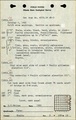 Fieldnote 4781-4782.pdf 752 × 1,185; 208 KB
 M0371 coalreport1888 p416.pdf 1,587 × 1,300; 1,000 KB
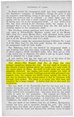 M0371 coalreport1889 p54.pdf 733 × 1,181; 415 KB
 M0371 coalreport1891 p132.pdf 793 × 1,275; 1.44 MB
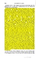
 M0371 coalreport1903 p232.pdf 720 × 1,172; 341 KB
 M0371 coalreport1908 p301.pdf 629 × 970; 110 KB
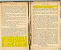
 M0371 minenotes.pdf 760 × 1,189, 7 pages; 2.01 MB
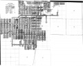
 M0371.jpg 3,390 × 1,979; 2.53 MB
 M0679 minenotes.pdf 745 × 1,189, 29 pages; 6.6 MB
 M0679.jpg 3,390 × 2,671; 2.32 MB

