4154: Difference between revisions
(Created page with "{{Sidebar Info Query}} {{Header |checked=1st Entry |unlocated=No |shown_on_map=Yes |Mine-index=4154 |Coal_co=Kenneth McDonald |Mine Name Header=McDonald Mine |mine_type=Underg...") |
No edit summary |
||
| (3 intermediate revisions by 3 users not shown) | |||
| Line 1: | Line 1: | ||
{{Sidebar Info Query}} | {{Sidebar Info Query}} | ||
{{Header | {{Header | ||
|checked= | |checked=Checked OK | ||
|unlocated=No | |unlocated=No | ||
|shown_on_map= | |shown_on_map=No | ||
|reason_nsm=Not shown on the accompanying map due to later surface mining by various operators. | |||
|Mine-index=4154 | |Mine-index=4154 | ||
|Coal_co=Kenneth McDonald | |Coal_co=Kenneth McDonald | ||
|Mine Name Header=McDonald Mine | |Mine Name Header=McDonald Mine | ||
|mine_type=Underground | |mine_type=Underground | ||
|mined-out-area=4 {{#info: | |mined-out-area=4 {{#info:The area shown for this mine is too large for the reported production. The source map shows only the haulage routes and general direction of the rooms. McDonald may have extended or connected to another older underground mine. This is supported by a note on the source map saying “air course through east mine”.|note}} | ||
|indicated=No | |||
|county1=Williamson | |county1=Williamson | ||
|quad1=Crab Orchard | |quad1=Crab Orchard | ||
|year-start=1933 | |year-start=1933 | ||
|year-end=1938 | |year-end=1938 | ||
|Latitude= | |Latitude=37.70169585 | ||
|Longitude= | |Longitude=-88.78816314 | ||
|Zoom=15 | |Zoom=15 | ||
}} | }} | ||
| Line 44: | Line 46: | ||
|Date=1933-1938 {{#info: Idle 1937|note}} | |Date=1933-1938 {{#info: Idle 1937|note}} | ||
|Production=7,818 | |Production=7,818 | ||
|Sum=No | |||
}} | }} | ||
{{Production | {{Production | ||
|Production=--------- | |Production=--------- | ||
|Sum=No | |||
}} | }} | ||
{{Production | {{Production | ||
|Production=7,818 | |Production=7,818 | ||
|Sum=Yes | |||
}} | }} | ||
===Production Notes=== | ===Production Notes=== | ||
| Line 58: | Line 63: | ||
{{Source map header}} | {{Source map header}} | ||
{{Source Map | {{Source Map | ||
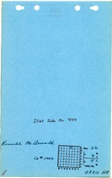
|Source Map= | |Source Map=State archive, IL_1430_01 | ||
|Map Date=8-3-1937 | |Map Date=8-3-1937 | ||
|Original Scale=1:1200 | |Original Scale=1:1200 | ||
| Line 75: | Line 80: | ||
}} | }} | ||
{{Annotated bibliography | {{Annotated bibliography | ||
|bibliography= | |bibliography=State archive map, IL_1430_01 - Slope location, mine outline, mining method. | ||
}} | }} | ||
==Mine Notes== | ==Mine Notes== | ||
Latest revision as of 11:41, June 30, 2023
Mine Index Number: 4154
| Company Name: | Kenneth McDonald | ||
|---|---|---|---|
| Mine Name: | McDonald Mine | ||
| Start Date: | 1933 | End Date: | 1938 |
| Type of Mine: | Underground | ||
| Total acres shown: | 4 The area shown for this mine is too large for the reported production. The source map shows only the haulage routes and general direction of the rooms. McDonald may have extended or connected to another older underground mine. This is supported by a note on the source map saying “air course through east mine”. | ||
| Acres after map date: | General Area of mining acres shown: | ||
|
Not Shown On Map. Not shown on the accompanying map due to later surface mining by various operators. | |||
Shaft, Slope, Drift or Tipple Location(s)
| Type | County | Township-Range | Section | Part Section |
|---|
| Main slope | Williamson | 9S 4E | 32 | NW NW NE |
Geology
| Thickness (ft) | |||||
|---|---|---|---|---|---|
| Seam | Depth (ft) | Min | Max | Ave | Mining Method |
| Springfield | MRP |
Geological Problems Reported
Production
| Company | Mine Name | Date | Production (tons) |
| Kenneth McDonald | McDonald | 1933-1938 Idle 1937 | 7,818 |
| Total Production: 7,818 | |||
Production Notes
Coal Report production (if available)
Sources of Data
| Source Map | Map Date | Original Scale | Digitized Scale | Map Type |
| State archive, IL_1430_01 | 8-3-1937 | 1:1200 | 1:1200 | Final |
Annotated Bibliography (Data source - brief description of information)
| Coal Reports - Production, ownership, years of operation. |
| Directory of Illinois Coal Mines (Williamson County) - Mine names, mine index, ownership, years of operation. |
| Mine notes (Williamson County) - Mine type, slope location, seam. |
| State archive map, IL_1430_01 - Slope location, mine outline, mining method. |
Mine Notes
Mine Images
![[[:McDonald|McDonald]]](https://go.illinois.edu/ILMImages/williamson/thumbnails/m4154_IL_1430_01_geo_th.jpg)
Photographs