0036: Difference between revisions
Alan.Myers (talk | contribs) No edit summary |
No edit summary |
||
| Line 1: | Line 1: | ||
{{Sidebar Info Query}} | {{Sidebar Info Query}} | ||
{{Header | {{Header | ||
|checked=1st Entry | |||
|unlocated=No | |unlocated=No | ||
|shown_on_map=Yes | |shown_on_map=Yes | ||
| Line 63: | Line 64: | ||
|Date=1894-1902 | |Date=1894-1902 | ||
|Production=1,456,032 | |Production=1,456,032 | ||
|Sum=No | |||
}} | }} | ||
{{Production | {{Production | ||
| Line 69: | Line 71: | ||
|Date=1902-1916 | |Date=1902-1916 | ||
|Production=4,334,685 | |Production=4,334,685 | ||
|Sum=No | |||
}} | }} | ||
{{Production | {{Production | ||
| Line 75: | Line 78: | ||
|Date=1916-1918 | |Date=1916-1918 | ||
|Production=957,684 | |Production=957,684 | ||
|Sum=No | |||
}} | }} | ||
{{Production | {{Production | ||
| Line 81: | Line 85: | ||
|Date=1918-1924 | |Date=1918-1924 | ||
|Production=1,736,281 | |Production=1,736,281 | ||
|Sum=No | |||
}} | }} | ||
{{Production | {{Production | ||
| Line 87: | Line 92: | ||
|Date=1924-1932 | |Date=1924-1932 | ||
|Production=2,246,608 | |Production=2,246,608 | ||
|Sum=No | |||
| | |||
}} | }} | ||
{{Production | {{Production | ||
|Production=10,731,290 | |Production=10,731,290 | ||
|Sum=Yes | |||
}} | }} | ||
===Production Notes=== | ===Production Notes=== | ||
Latest revision as of 15:15, June 2, 2022
Mine Index Number: 0036
| Company Name: | Peabody Coal Company | ||
|---|---|---|---|
| Mine Name: | Peabody No. 52 Mine | ||
| Start Date: | 1894 | End Date: | March 1932 |
| Type of Mine: | Underground | ||
| Total acres shown: | 2,995 | ||
| Acres after map date: | General Area of mining acres shown: | ||
Shaft, Slope, Drift or Tipple Location(s)
| Type | County | Township-Range | Section | Part Section |
|---|
| Main shaft | Sangamon | 16N 4W | 10 | 2550 FSL, 2630 FEL |
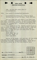
| Air shaft | Sangamon | 16N 4W | 9 | NE NE SW Additional air shafts are shown west of the main shaft complex, which were the hoist and escape shafts for Riverton No. 1 Mine (mine index 3345). The workings were connected underground. |
| Air shaft | Sangamon | 16N 4W | 22 | NW SW NE |
Geology
| Thickness (ft) | |||||
|---|---|---|---|---|---|
| Seam | Depth (ft) | Min | Max | Ave | Mining Method |
| Springfield | 232 | 5.8 | 6.2 | 5.9 | RPP |
Geological Problems Reported
The roof was black shale that ranged from 2.5 to 4.0 feet thick. Pyrite bands and black jack were present as impurities in the coal.
Production
| Company | Mine Name | Date | Production (tons) |
| Riverton Coal Company | Riverton No. 2 | 1894-1902 | 1,456,032 |
| Springfield Coal and Mining Company | Riverton No. 2 | 1902-1916 | 4,334,685 |
| Springfield District Coal Company | Springfield District No. 2 | 1916-1918 | 957,684 |
| Springfield District Coal Company | Springfield District No. 52 | 1918-1924 | 1,736,281 |
| Peabody Coal Company | Peabody No. 52 | 1924-1932 | 2,246,608 |
| Total Production: 10,731,290 | |||
Production Notes
Coal Report production (if available)
Sources of Data
| Source Map | Map Date | Original Scale | Digitized Scale | Map Type |
| Microfilm, document 351228 | 5-20-1932 | 1:2400 | 1:4800 | Final |
| State archive, IL_451 | 9-21-1951 | 1:2400 | 1:2400 | Final |
Annotated Bibliography (Data source - brief description of information)
| Coal Reports - Production, ownership, years of operation. |
| Directory of Illinois Coal Mines (Sangamon County) - Mine names, mine index, ownership, years of operation. |
| Mine notes (Sangamon County) - Mine type, seam, depth, thickness, geologic problems. |
| Microfilm map, document 351228, reel 03134, frames 445-453 - Shaft locations, mine outline, mining method. |
| State archive, IL_451, map of Peabody No. 57 Mine (mine index 37), courtesy of Robert Gibson, IDNR - Air shaft (southern). |
Mine Notes

Mine Images

Photographs