3317: Difference between revisions
Alan.Myers (talk | contribs) No edit summary |
No edit summary |
||
| Line 8: | Line 8: | ||
|Mine Name Header=Davenport Mine | |Mine Name Header=Davenport Mine | ||
|mine_type=Underground | |mine_type=Underground | ||
| | |after_map=5 | ||
|indicated=Yes | |||
|gam=21 | |gam=21 | ||
|county1=Saline | |county1=Saline | ||
|quad1=Carrier Mills | |quad1=Carrier Mills | ||
|city1=Carrier Mills | |||
|year-start=1908 | |year-start=1908 | ||
|year-end=1910 | |year-end=1910 | ||
Latest revision as of 15:48, March 12, 2024
Mine Index Number: 3317
| Company Name: | Davenport Mining Company | ||
|---|---|---|---|
| Mine Name: | Davenport Mine | ||
| Start Date: | 1908 | End Date: | 1910 |
| Type of Mine: | Underground | ||
| Total acres shown: | |||
| Production Indicated Acres: | 5 | General Area of mining acres shown: | 21 |
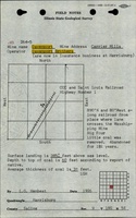
Shaft, Slope, Drift or Tipple Location(s)
| Type | County | Township-Range | Section | Part Section |
|---|
| Main shaft (8.5'x15') | Saline | 10S 5E | 9 | NE NE SW |
| Air shaft (8'x12') | Saline | 10S 5E | 9 | SWNot shown on accompanying map because of the lack of an adequate source map for this mine. The 1908 Coal Report described the air shaft. |
Geology
| Thickness (ft) | |||||
|---|---|---|---|---|---|
| Seam | Depth (ft) | Min | Max | Ave | Mining Method |
| Davis | 60 | 3.0 | RP |
Geological Problems Reported
Production
| Company | Mine Name | Date | Production (tons) |
| Davenport Mining Company Shown on the source map as Davis Coal Company. | Davenport | 1908-1910 | 15,466 |
| Total Production: 15,466 | |||
Production Notes
Coal Report production (if available)
Sources of Data
| Source Map | Map Date | Original Scale | Digitized Scale | Map Type |
| Mine notes | Undated | (text only) | 1:24000Point plotted onto 1:24,000 USGS quadrangle and digitized. | Secondary source |
| Coal Section files, PB_296_01 | 4-18-1968 | 1:12000 | 1:12000 | Secondary source |
Annotated Bibliography (Data source - brief description of information)
| Coal Reports - Production, ownership, years of operation, shaft sizes, mining method. |
| Directory of Illinois Coal Mines (Saline County) - Mine names, mine index, ownership, years of operation. |
| Mine notes (Saline County) - Mine type, shaft location, seam. |
| ISGS field notes (Saline County) - Shaft location, depth, thickness. |
| Coal Section files, PB_296_01, from the State Archives, courtesy of Robert Gibson of the Department of Natural Resources and Peabody Energy - General area of mining. |
Mine Notes
Mine Images

Photographs