4100: Difference between revisions
No edit summary |
No edit summary |
||
| Line 50: | Line 50: | ||
{{Source Map | {{Source Map | ||
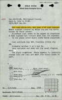
|Source Map=ISGS field notes (G. H. Cady) | |Source Map=ISGS field notes (G. H. Cady) | ||
|Map Date=1925 | |Map Date=7-2-1925 | ||
|Original Scale=1:62500 | |Original Scale=1:62500 | ||
|Digitized Scale=1:62500 | |Digitized Scale=1:62500 | ||
Latest revision as of 10:55, March 18, 2024
Mine Index Number: 4100
| Company Name: | Unknown | ||
|---|---|---|---|
| Mine Name: | Unknown Mine | ||
| Start Date: | Before 1925 | End Date: | Unknown |
| Type of Mine: | Surface | ||
| Total acres shown: | None | ||
| Acres after map date: | General Area of mining acres shown: | ||
Shaft, Slope, Drift or Tipple Location(s)
| Type | County | Township-Range | Section | Part Section |
|---|
| Pit | Williamson | 9S 4E | 24 | SW SE SW |
Geology
| Thickness (ft) | |||||
|---|---|---|---|---|---|
| Seam | Depth (ft) | Min | Max | Ave | Mining Method |
| Herrin | 4.0 | Surface |
Geological Problems Reported
Production
| Company | Mine Name | Date | Production (tons) |
Production Notes
Coal Report production (if available)
Sources of Data
| Source Map | Map Date | Original Scale | Digitized Scale | Map Type |
| ISGS field notes (G. H. Cady) | 7-2-1925 | 1:62500 | 1:62500 | Secondary source |
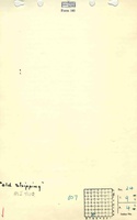
| Mine notes | Undated | 1:62500 | 1:62500 | Secondary source |
Annotated Bibliography (Data source - brief description of information)
| ISGS field notes (Williamson County) - Mine type, mine location. |
| Mine notes (Williamson County) - Mine location, seam, thickness. |
Mine Notes
Mine Images
Photographs