4213: Difference between revisions
Alan.Myers (talk | contribs) No edit summary |
No edit summary |
||
| Line 5: | Line 5: | ||
|shown_on_map=Yes | |shown_on_map=Yes | ||
|Mine-index=4213 | |Mine-index=4213 | ||
|Coal_co=Unknown | |||
|Mine Name Header=Bald Hill Mine | |Mine Name Header=Bald Hill Mine | ||
|mine_type=Underground | |mine_type=Underground | ||
|mined-out-area=None | |mined-out-area=None | ||
|indicated=No | |||
|county1=Williamson | |county1=Williamson | ||
|quad1=Stonefort | |quad1=Stonefort | ||
|year-start=9999 | |year-start=9999 | ||
|year-end= | |datemodend=Before | ||
|year-end=1961 | |||
|Latitude=37.60256147 | |Latitude=37.60256147 | ||
|Longitude=-88.74173516 | |Longitude=-88.74173516 | ||
| Line 31: | Line 34: | ||
{{Geology seam | {{Geology seam | ||
|Seam=Bald Hill {{#info: The Bald Hill Coal is the same as the Mt. Rorah Coal Member of the Spoon Formation, according to Bulletin 95, page 185.|note}} | |Seam=Bald Hill {{#info: The Bald Hill Coal is the same as the Mt. Rorah Coal Member of the Spoon Formation, according to Bulletin 95, page 185.|note}} | ||
|mining-method=Underground | |||
}} | }} | ||
===Geological Problems Reported=== | ===Geological Problems Reported=== | ||
| Line 53: | Line 57: | ||
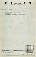
|Source Map=ISGS field notes (W. E. Parham) | |Source Map=ISGS field notes (W. E. Parham) | ||
|Map Date=1961 | |Map Date=1961 | ||
|Original Scale= | |Original Scale=1:62500 | ||
|Digitized Scale=1: | |Digitized Scale=1:62500 | ||
|Map Type=Secondary source | |Map Type=Secondary source | ||
}} | }} | ||
Revision as of 12:11, April 16, 2024
Mine Index Number: 4213
| Company Name: | Unknown | ||
|---|---|---|---|
| Mine Name: | Bald Hill Mine | ||
| Start Date: | Unknown | End Date: | Before 1961 |
| Type of Mine: | Underground | ||
| Total acres shown: | None | ||
| Acres after map date: | General Area of mining acres shown: | ||
Shaft, Slope, Drift or Tipple Location(s)
| Type | County | Township-Range | Section | Part Section |
|---|
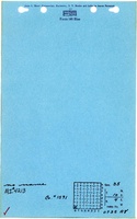
| Main slope | Williamson | 10S 4E | 35 | NE SW SW |
Geology
| Thickness (ft) | |||||
|---|---|---|---|---|---|
| Seam | Depth (ft) | Min | Max | Ave | Mining Method |
| Bald Hill The Bald Hill Coal is the same as the Mt. Rorah Coal Member of the Spoon Formation, according to Bulletin 95, page 185. | Underground |
Geological Problems Reported
Production
| Company | Mine Name | Date | Production (tons) |
| Unknown | Bald Hill | Unknown | Unknown |
Production Notes
Coal Report production (if available)
Sources of Data
| Source Map | Map Date | Original Scale | Digitized Scale | Map Type |
| ISGS field notes (W. E. Parham) | 1961 | 1:62500 | 1:62500 | Secondary source |
Annotated Bibliography (Data source - brief description of information)
| Directory of Illinois Coal Mines (Williamson County) - Mine name, mine index. |
| ISGS field notes (Williamson County) - Mine type, slope location, seam. |
Mine Notes
Mine Images
Photographs