Mine Index Number: 4477
| Company Name:
|
Templeton and Treyning
|
| Mine Name:
|
Templeton Mine
|
| Start Date:
|
1916
|
End Date:
|
1918
|
| Type of Mine:
|
Underground
|
| Total acres shown:
|
None
|
| Production Indicated Acres:
|
3
|
General Area of mining acres shown:
|
|
|
|
Shaft, Slope, Drift or Tipple Location(s)
| Type
|
County
|
Township-Range
|
Section
|
Part Section
|
| Slope or drift
|
Williamson
|
10S 2E
|
23
|
SE SE NE
|
Geology
| Tarter The coal correlates to the Tarter Coal in western Illinois, and is approximately equivalent to the Lower Block Coal in Indiana and Coal 4a in western Kentucky.
|
22
|
|
|
3.5-4.0 (est.)
|
RP
|
Geological Problems Reported
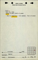
The mine was filled with water when the location was noted in 1932.
Production
| Company
|
Mine Name
|
Date
|
Production (tons)
|
Production Notes
Coal Report production (if available)
Sources of Data
| ISGS field notes (Cady and Benson)
|
7-10-1932
|
(text only)
|
1:24000 The mine location was plotted on a 1:24,000 USGS topographic map from the mine location description and digitized.
|
Secondary source
|
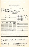
| Coal Section files, 1-17-13b
|
Undated
|
1:31250
|
1:31250
|
Secondary source
|
Annotated Bibliography (Data source - brief description of information)
| Coal Reports - Production, ownership, years of operation.
|
| Directory of Illinois Coal Mines (Williamson County) - Mine names, mine index, ownership, years of operation.
|
| ISGS field notes (Williamson County) - Mine type, slope or drift location, depth, thickness.
|
| Russ Jacobson (ISGS), personal communication - Seam.
|
| W.J. Nelson (ISGS), Catalog of Coal Mines in Williamson County, 2003 - Seam.
|
| Coal Section files, 1-17-13b - Mine location.
|
Mine Notes
Mine Images
 These files may not be true to scale and are not georgistered. These files may not be true to scale and are not georgistered.
|
Map Type:
|
Coal Section files
|
| Map ID:
|
1-17-13b
|
| Company:
|
|
| Mine Name:
|
|
| Caption:
|
|
| Map Date:
|
Undated
|
| Map Status:
|
Secondary
|
| Image Credit:
|
|
| Note:
|
|
| More Info:
|
1-17-13b
|
| Full Res Download:These files are true to scale and most are georegistered for gis software. These files may be a very large (>1GB) download!
|
https://wikiimage.isgs.illinois.edu/ilmines/williamson/1-17-13b.zip
|
Photographs