Mine Index Number: 0404
| Company Name:
|
South Side Coal Company
|
| Mine Name:
|
South Side Mine
|
| Start Date:
|
1892
|
End Date:
|
1941
|
| Type of Mine:
|
Underground
|
| Total acres shown:
|
136
|
| Production Indicated Acres:
|
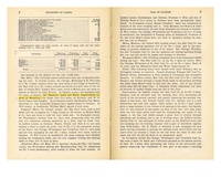
6The area depicted is smaller than expected for the reported production. The map showing the oldest part of the mine shows the earliest survey date of November 1913. The general area of mining shown on the accompanying map may be too small to accurately depict the mining from 1892 to the 1913 survey. The mine should total approximately 200 acres.
|
General Area of mining acres shown:
|
|
|
|
Shaft, Slope, Drift or Tipple Location(s)
| Type
|
County
|
Township-Range
|
Section
|
Part Section
|
| Main shaft
|
La Salle
|
33N 4E
|
25
|
NE NW NE
|
| Escape shaft
|
La Salle
|
33N 4E
|
25
|
NE NW NE
|
Geology
| Colchester
|
90-110
|
|
|
2.5-5.0
|
LW (old longwall)
|
Geological Problems Reported
The source map showed water prevented expansion in the east-southeast part of the mine. The coal contained pyrite lenses that were very difficult to separate from the coal. The seam also contained bone coal layers and a gypsum band up to 1 inch thick that was persistent throughout the mine.
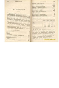
Production
| Company
|
Mine Name
|
Date
|
Production (tons)
|
|
|
|
|
|
| Total Production: 1,075,657
|
Production Notes
Coal Report production (if available)
Sources of Data
| Microfilm, document 352440
|
10-19-1928
|
1:1200
|
1:2234
|
Not final
|
| Company, 4103.L32 i5.1-6
|
8-28-1941
|
1:600
|
1:600
|
Final
|
| Microfilm, document 352398
|
4-5-1933
|
1:1200
|
1:1986
|
Not final
|
Annotated Bibliography (Data source - brief description of information)
| Coal Reports - Production, ownership, years of operation, thickness.
|
| Mine notes (La Salle County) - Mine type, shaft location, seam, depth, thickness, geologic problems.
|
| Microfilm map, document 352440, reel 03139, frame 116 - Shaft locations, mine outline, method, geologic problems.
|
| Company map, ISGS map library 4103.L32 i5.1-6 - Partial outline (SW part of mine), mining method.
|
| Microfilm map, document 352398, reel 03139, frame 49 - Partial outline (NW part of mine), mining method.
|
Mine Notes
Mine Images
Photographs