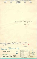
Mine Index Number: 0867
| Company Name:
|
Breese-Trenton Mining Company
|
| Mine Name:
|
Trenton Mine or West Mine
|
| Start Date:
|
1905
|
End Date:
|
1912
|
| Type of Mine:
|
Underground
|
| Total acres shown:
|
180
|
| Acres after map date:
|
70-90
|
General Area of mining acres shown:
|
|
|
|
Shaft, Slope, Drift or Tipple Location(s)
| Type
|
County
|
Township-Range
|
Section
|
Part Section
|
| Main shaft
|
St. Clair
|
2N 6W
|
25
|
NE SE NE
|
| Air shaft
|
St. Clair
|
2N 6W
|
25
|
NE SE NE
|
Geology
| Herrin
|
320-345
|
|
|
4.5-5.0
|
MRP
|
Geological Problems Reported
Production
| Company
|
Mine Name
|
Date
|
Production (tons)
|
|
|
|
|
|
| Total Production: 973,434
|
Production Notes
Coal Report production (if available)
Sources of Data
| State archive, PC_94_01
|
5-18-1911
|
1:2400
|
1:2400
|
Not final
|
Annotated Bibliography (Data source - brief description of information)
| Coal Reports - Production, ownership, years of operation, seam, depth, thickness.
|
| Directory of Illinois Coal Mines (St. Clair County) - Mine names, mine index, ownership, years of operation.
|
| State archive, PC_94_01 - Mine outline, shaft locations, mining method.
|
Mine Notes
Mine Images
Photographs
![[[:Trenton|Trenton]]](https://wikiimage.isgs.illinois.edu/ilmines/st_clair/thumbnails/PC_94_01_geo_th.jpg)
![[[:Trenton|Trenton]]](https://wikiimage.isgs.illinois.edu/ilmines/st_clair/thumbnails/M0867_IL_142_01_th.jpg)